- Brief description
-
With the e-bike through the ancient county of Gruyère.
- Difficulty
-
difficult
- Rating
-
- Starting point
-
Saanen, railway station
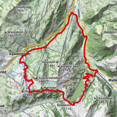
- Route
-
Saanen (1,010 m)Saanen (1,014 m)0.1 kmRougemont4.0 kmLes Revers (970 m)4.0 kmSaint-Nicolas4.5 kmGérignoz8.2 kmLes Granges9.1 kmRestolesgranges9.2 kmLes Granges-Gérignoz (1,003 m)9.3 kmChâteau-d'Oex11.3 kmLe Pré12.7 kmLes Moulins13.9 kmMontbovon22.2 kmMontbovon (797 m)22.5 kmAuberge de La Couronne25.9 kmLissingen (812 m)26.0 kmÉglise paroissiale Saint-Martin26.1 kmLangwiler (762 m)30.2 kmSaint-Jacques30.2 kmRestaurant du Vanil Noir30.3 kmEstavannens (803 m)33.1 kmViewpoint36.3 kmPringy37.0 kmChapelle Sainte Agathe37.1 kmGruyères (810 m)38.0 kmÉpagny38.4 kmRestaurant de la Grue40.6 kmBruck (718 m)40.6 kmHotel de Ville40.7 kmPré de Joux44.0 kmLe Baron48.8 kmLa Bourliandaz49.8 kmIm Fang54.1 kmJaun (1,015 m)57.5 kmCascade de Jaun57.6 kmRestaurant Wasserfall57.7 kmAbländschen63.7 kmRestaurant Zitbödeli64.0 kmSaanen (1,014 m)80.0 kmSaanen (1,010 m)80.3 km
- Best season
-
JanFebMarAprMayJunJulAugSepOctNovDec
- Description
-
A beautiful medium-long tour on secondary roads leads through the authentic home of the famous Swiss cheese «Gruyère». The long final ascent from Jaun to the Mittelberg pass is not to be underestimated.
http://www.strava.com/routes/1145572 - Directions
-
Saanen - Montbovon - Gruyère - Broc - Jaun - Mittelberg - Saanen
- Highest point
- 1,633 m
- Endpoint
-
Saanen, railway station
- Height profile
-
 © outdooractive.com
 - Equipment
-
Clothing and equipment appropriate to the weather, tool kit and first aid kit.
- Tips
-
A break at the waterfall in Jaun before the last ascent.
- Additional information
- Directions
-
The Destination Gstaad is located in the south-west of Switzerland right on the border to the French-speaking part of the country. The Destination is easily accessed by rail or car from the regions around Lake Thun and Lake Geneva and the Gruyere region Direct connections to the European high-speed rail network and all international airports in Switzerland guarantee a time-saving and pleasant journey.
- Public transportation
-
Saanen station


-

-
AuthorThe tour Tour de Gruyère is used by outdooractive.com provided.
GPS Downloads


General info
Refreshment stop
A lot of view
Other tours in the regions
-
Alpes Vaudoises
103
-
Pays-d’Enhaut Région
72
-
Rougemont
19