
- Brief description
-
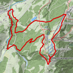
Anspruchsvolle Tour mit traumhaften Rundumblick.
- Difficulty
-
medium
- Rating
-
- Route
-
Fellhornstuben0.0 kmAnatswald1.0 kmBirgsau2.1 kmAlpe Eschbach2.3 kmAlpe Eschbach2.6 kmSt. Katharina4.3 kmBerggasthof Einödsbach4.3 kmEinödsbach4.4 kmEnzianhütte8.0 km
- Highest point
- 1,788 m
- Endpoint
-
Enzianhütte
- Height profile
-
 © outdooractive.com
- Author
-
The tour Enzianhütte - Allgäuer Picknickplätze is used by outdooractive.com provided.
GPS Downloads


General info
Refreshment stop
A lot of view
Other tours in the regions