
- Brief description
-
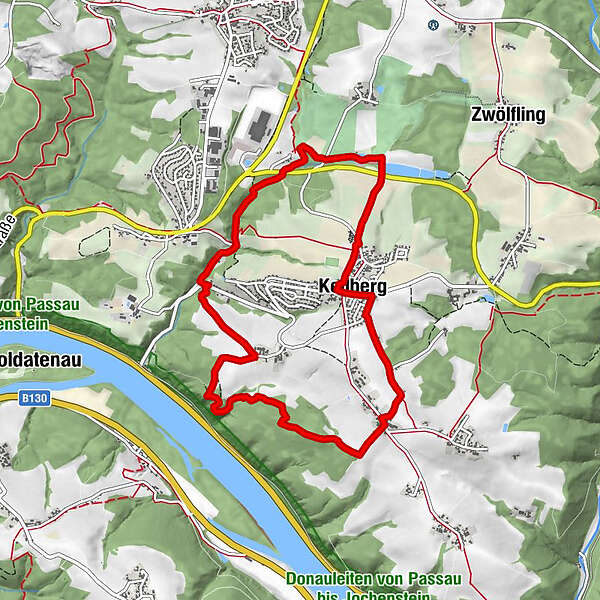
König-Max-Höhe – Hochsteinweg Trail - Donaublick - Buchsee – Facklmühle Mill – Grafmühle Mill - Hörreut - Kellberg
- Difficulty
-
medium
- Rating
-
- Starting point
-
Kellberg
- Route
-
St. Leonhard-Kapelle0.0 kmPizzeria Bel Paese0.0 kmLourdeskapelle0.0 kmSt. Blasius0.1 kmKellberg0.2 kmMaxhöhe1.3 kmGaststätte zur König-Max-Höhe1.4 kmWingersdorf1.5 kmDonaublick3.5 kmHochstein, Donaublick3.5 kmBuchsee4.3 kmGrafmühle5.7 kmHörreut6.6 kmKellberg8.8 km
- Best season
-
JanFebMarAprMayJunJulAugSepOctNovDec
- Description
-
From the starting place at Kurgästehaus, St-Blasius-Straße 10 in Kellberg we hike southwards and take a left turn. We follow the road and at the end of the village we take a right turn into Lindenstraße road and leave the settlement to the left after some 200m. We follow the road to König-Max Höhe. There we meet Donausteig Trail and follow it to Grafmühle Mill. There we leave Donausteig Trail to the right and hike through the forest at the end of which we pass the tennis courts and asphalt alleys. We take a right turn there and hike past Winterweiher pond back into the village.
- Highest point
- 517 m
- Endpoint
-
Kurgästehaus in Kellberg
- Height profile
-
 © outdooractive.com
 - Safety instructions
-
Sturdy hiking boots required
- Tips
-
König-Max-Höhe and Donaublick are very nice vantage points with a resting place each. Worthwhile is also Grafmühle (old bakery) that has been owned by the Bauer Family since 1713. It is one of the oldest mills and bakery businesses of Germany.
In the village centre of Kellberg ist the Blacksmith’s Museum. Outdoor activities can be enjoyed at the Raßbach natural bathing pond with beach volleyball court and tennis court, the golf course at Hotel Anetseder’s and also at the crazy golf course at Gasthaus Duschl in Wingersdorf.
- Additional information
- Directions
- Public transportation
- Parking
-
Free parking spaces without time limit at the Kurgästehaus Kellberg (large car park at the back of the building; access from Eggersdorfer Straße road into Schulweg)
- Author
-
The tour Kellberg: Kellberg Celtic Tour is used by outdooractive.com provided.


General info
-
Passauer Land
161
-
Thyrnau - Kellberg
47