
- Brief description
-
Multi-summit tour for fit snow shoe hikers with a good sense of direction
- Difficulty
-
difficult
- Rating
-
- Starting point
-
Car park at the Tannenbankerl ski lift
- Route
-
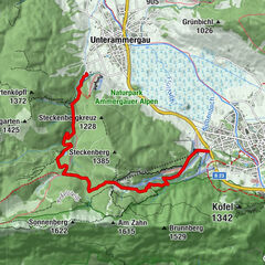
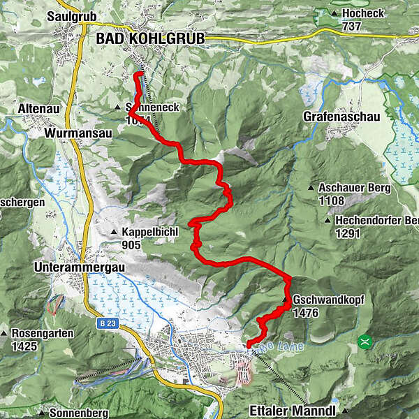
Bad Kohlgrub (828 m)Stockhang-Schlepplift1.3 kmZeitberg (1,404 m)2.1 kmVorderes Hörnle (1,484 m)2.5 kmMittleres Hörnle (1,496 m)2.9 kmHörnlealm3.2 kmHinteres Hörnle (1,548 m)4.1 kmStierkopf (1,533 m)4.4 kmGroßer Aufacker (1,542 m)10.3 km
- Best season
-
AugSepOctNovDecJanFebMarAprMayJunJul
- Description
-
Attractive tour over the Hörnle and the Stierkopf to the Großer Aufacker. The first part of the route mostly involves hiking through open terrain at the edge of the ski piste. The middle section provides the best panoramic views. The transition from the Stierkopf to the großer Aufacker is mostly through forest with individual glimpses of the mountain landscapes of te Ammergauer Alps.
The course was developed in 2015 by the German Alpine Association working in conjunction with local representatives (forestry, hunting and farmers) as part of the “Environmentally friendly mountain skiing and climbing” project. - Directions
-
The tour starts at the car park located above the valley station of the Tannenbankerl ski lift. Follow the ski slope to the right through a small wood. You then ascend to the Sonneneck, keeping the ski slope to your left at all times. Continue via the right-hand edge of the family downhill run past the mountain rescue hut until you reach the Hörnle Hut.
Please look out for descending skiers and keep to the edge of the slope.
From the Hörnle Hut, pass the Hörnle mountain cross country ski route on your left and proceed via the Vorderes Hörnle. You now descend slightly. Go past the Hörnle Alm and, on the opposite side of the mountain pasture, climb a few hundred metres to the Hinteres Hörnle.
The route continues downhill via the summit of the Stierkopf to the peak of the Drei Marken. From here on, a good sense of direction is required since the route to the next summit, the großer Aufacker, is mostly through mountain forest. Start by following the forest road heading towards Oberammergau/Romanshöhe. At a large crossroads with open views (Protzenau), enter the woods below the forest road to remerge onto the same road a few hundred metres further on. At the next crossing, take the middle road. At the next bend, continue straight on into the woods. The route takes a sharp turn to the right, and you emerge into an open clearing, which will take you onto the summit of the Großer Aufacker.
The descent into the valley at Oberammergau is via the normal summer pathway.
At the edge of the village, you will come to the Wellenberg Adventure Pool. From here, it is a 15-minute walk to the station in Oberammergau. Take the train back to your starting point in Bad Kohlgrub.
Never get lost again. We recommend our free app "Ammergau Alp tour planner", which includes all tours in the region. - Highest point
- 1,538 m
- Endpoint
-
Car park at the WellenBerg Adventure Pool
- Height profile
-
 © outdooractive.com
 - Equipment
-
You can enjoy an unforgettable hiking experience in the Ammergau Alps as long as you have the right gear. Visit the "Best of Wandern" Test Centre in Bad Kohlgrub to try out the latest outdoor equipment free of charge.
- GPS devices
- rucksacks, child carriers, children's jackets
- multifunctional jackets
- hiking boots
- sticks and head lamps
- binoculars
- tour software
- snow shoes
- backpacking umbrellas
The Best of Wandern Test Centre is located at Hotel Schillingshof, directly opposite the Hörnlebahn ski lift.
adress: Fallerstraße 11, Bad Kohlgrub tel.: +49 8845 7010.For more information, visit: www.ammergauer-alpen.de/testcenter
- Directions
-
A95, Murnau St2062 to Bad Kohlgrub
- Public transportation
-
bus stop: Oberammergau, WellenBerg/Laberbergbahn
9606 Garmisch-Partenkirchen - Oberammergau - Wieskirche - Füssen
9622 Oberammergau - Ettal - Linderhof (Schloss)
train stop: Oberammergau Bahnhof
Murnau - OberammergauGuests in the Ammergauer Alps Region can use their electronic guest pass or the "KönigsCard" to obtain free bus travel.
- Parking
-
Car park at the Tannenbankerl ski lift


-

-
AuthorThe tour Snow shoe hike – from Bad Kohlgrub to Oberammergau is used by outdooractive.com provided.


General info
-
Ammergauer Alpen
19
-
Oberammergau
11