
- Brief description
-
This first variant of the Route des Grandes Alpes is an invitation to discover the beautiful city of Annecy, its lake and the Bauges Regional Nature Park, a wild and authentic massif. For beginners to medium cyclists, we prefer to make this variant in 2 days, a stop at Lescheraines being welcome. Day 2 takes you to the southern part of the massif, the Bauges, to join then the main route by Albertville and Beaufortain
- Difficulty
-
medium
- Rating
-
- Route
-
Saint-Jean-de-SixtLe Cabanon0.0 kmLe Peille0.0 kmLucia0.0 kmLes Faux0.3 kmForgeassoud-dessous0.8 kmForgeassoud-dessus1.4 kmLe Borgeal2.2 kmLe Liez2.4 kmLa Villaz3.0 kmCarrouge3.6 kmLes Villards-sur-Thônes4.0 kmLe Rété4.9 kmLa Vacherie5.1 kmLe Collège6.2 kmPré Varens6.9 kmLe Martinet7.2 kmThônes8.4 kmRestaurant La Ferme De Lorette9.4 kmThuy Dessous10.7 kmAuberge de Morette11.5 kmLa Balme-de-Thuy12.7 kmLes Isles13.4 kmAlex16.1 kmLes Teppes16.6 kmSur les Luzes18.8 kmLe Lodge des Dents de Lanfon19.1 kmLes Pénoz19.1 kmLa Charbonnière19.6 kmMontpellaz21.2 kmMorat22.2 kmÉglise Saint-Maurice23.1 kmVeyrier-du-Lac23.1 kmLes Champs24.0 kmLa Petite Reine24.2 kmPensières24.7 kmChavoire24.9 kmLe bistrot de l'amandier25.3 kmBois Jettaz26.1 kmÉglise Saint-François-de-Sales29.0 kmAnnecy29.0 kmAnnecy29.3 kmLa Puya30.3 kmBeau Rivage31.5 kml'Oasis Auberge du Bessard32.1 kmLe Bessard32.2 kmChuguet32.3 kmLétraz32.6 kmLes Avollions33.4 kmÉglise Saint-Blaise33.7 kmSevrier34.1 kmLe Clos35.5 kmAvellard36.7 kmSur Avellard36.8 kmLe Bouffard37.8 kmLa Côte (636 m)39.3 kmLa Baratte46.5 kmBellecombe-en-Bauges52.8 kmLes Dodes53.9 kmBroissieux54.5 kmChez Vergain55.0 kmEntrèves55.6 kmLa Charniaz (700 m)56.7 kmLa Madeleine58.5 kmLe Pont58.9 kmLe Plateau59.3 kmLes Poisats61.0 kmLa Motte-en-Bauges61.4 kmLe Rocher61.5 kmAuberge des Clarines63.1 kmLe Châtelard63.5 kmÉglise Saint-Jean-Baptiste64.2 kmLa Vipérine66.9 kmLe Pont67.0 kmÉcole68.8 kmÉglise Saint-Maurice68.9 kmGratteloup71.6 kmÉpernay72.4 kmSainte-Reine73.9 kmRouthennes75.6 kmLa Plantaz82.1 kmLa Chenolaz83.3 kmLa Montaz (481 m)83.9 kmLa Noiriat84.3 kmSaint-Pierre-d'Albigny85.2 kmMiolanet86.4 kmLe Bourget87.5 kmLe Villard88.5 kmFréterive89.6 kmLes Fiardières90.5 kmFontaine92.4 kmVue sur les portes de la Maurienne92.6 kmGrésy-sur-Isère93.6 kmLa Place93.8 kmMontailleur96.5 kmL'Epigny96.8 kmFournieux97.2 kmLes Chavannes97.4 kmSaint-Vital98.6 kmAuberge Savoyarde99.7 kmFrontenex99.7 kmGilly-sur-Isère103.8 kmAlbertville106.1 kmAlbertville108.1 kmPallud109.3 kmVenthon111.0 kmPlan Pitton115.1 kmGrange Neuve116.2 kmQueige116.3 kmLes Perrières122.1 kmLes Nantives122.5 kmVillard-sur-Doron122.7 kmEtraz122.9 kmLes Devies123.7 km
- Best season
-
JanFebMarAprMayJunJulAugSepOctNovDec
- Description
-
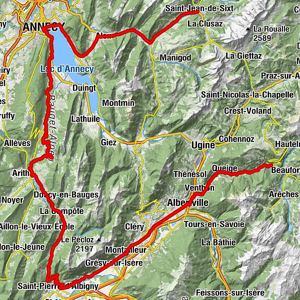
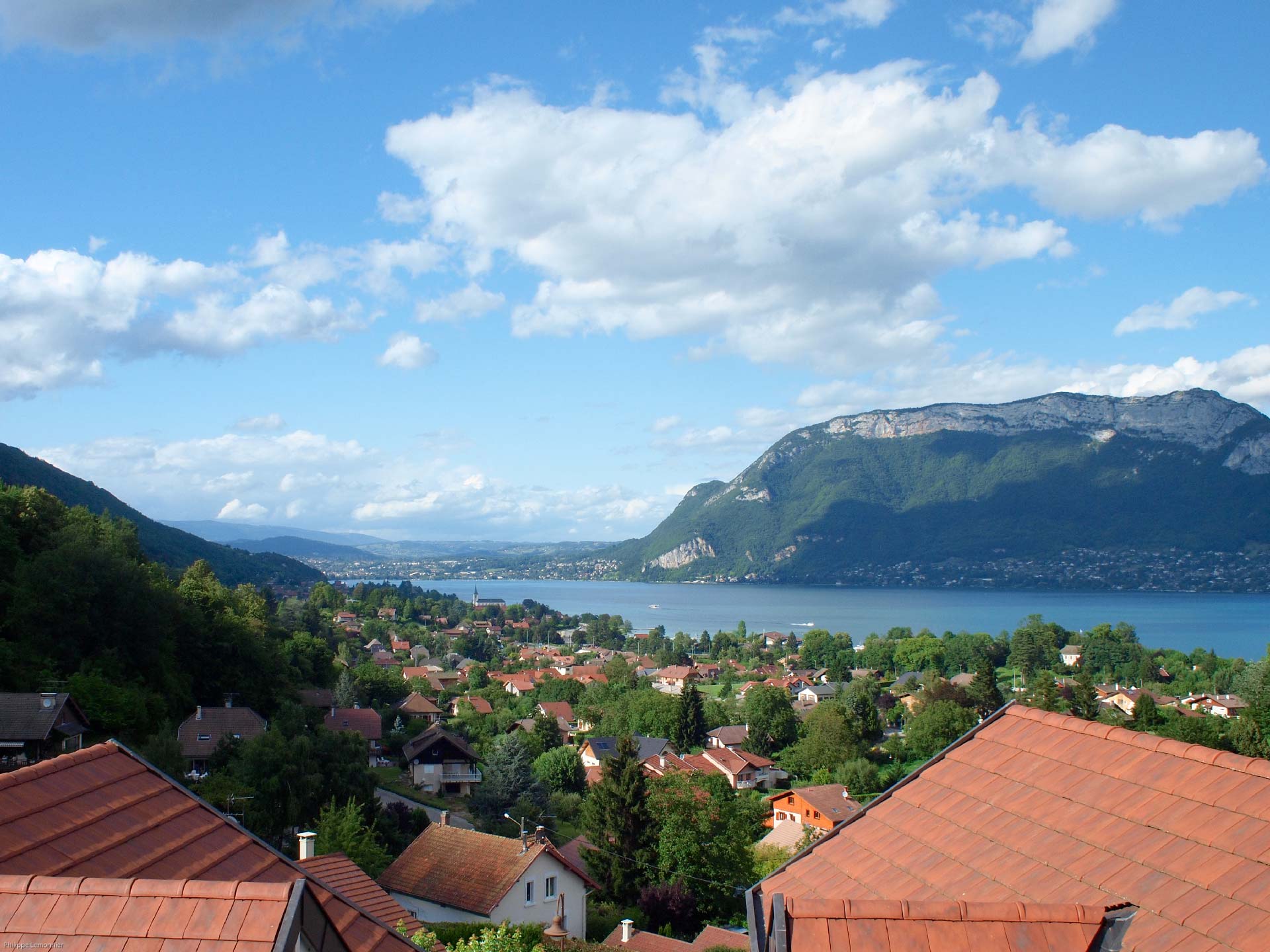
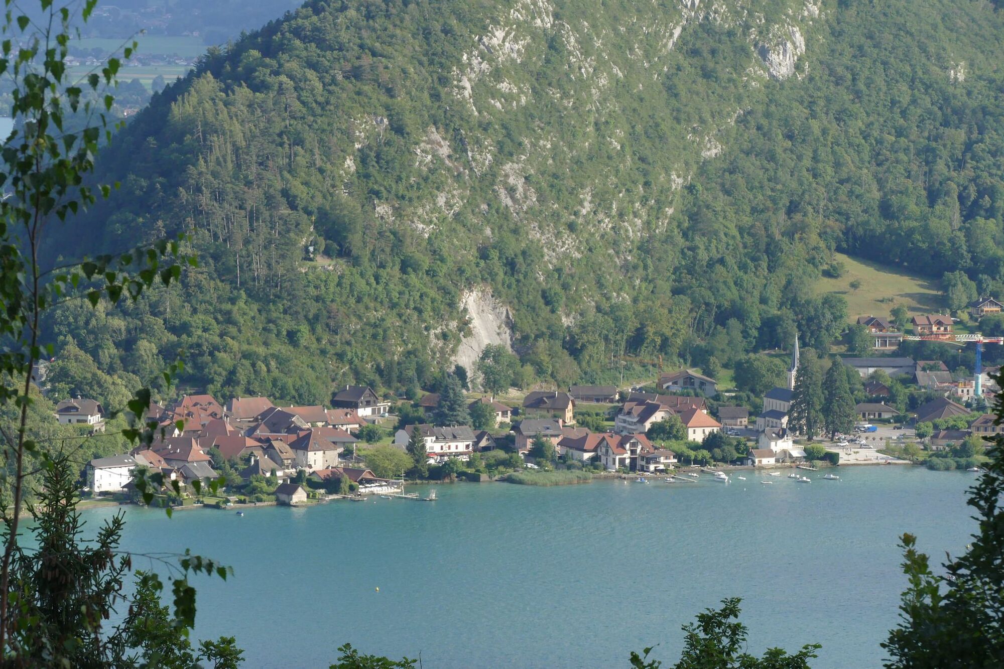
Day 1 - From Saint-Jean-de-Sixt, you will turn towards Thônes then continue towards Lac d'Annecy. Arrived on the shores of the lake in Menthon-Saint-Bernard you will follow it by the road and will soon be able to join the bike path that you will take until Sevrier. Take the time to visit the old town of Annecy, its alleys inherited from the Middle Ages, its castle and the many channels that characterize it. And why not eat an ice cream and take a dip before climbing back to the Parc des Bauges via the Col de Leschaux. Here you will find the alpine atmospheres of Savoy, alpine pastures, forests and some rocky peaks that could make you want to leave your bike for a few moments.
Day 2 - You will continue your crossing of Bauges in the tranquility of its landscapes. On this stage, typical villages, orchards and vineyards are waiting for you. The exit of the massif is done by Saint-Pierre-d'Albigny and the route continues along the Isère until Albertville. After a possible detour through Conflans, a pretty medieval town perched at 412 meters above sea level, you will join the main route of the Route des Grandes Alpes in the Beaufortain. - Directions
-
J1 - From Saint-Jean-de-Sixt follow the direction of Annecy on the D909 until Sevrier then climb towards the Bauges. At the Col de Leschaux, take the D10 towards Bellecombe-en-Bauges, then direction Lescheraines.
J2 - De Lescheraines, follow the direction of Châtelard then Saint-Pierre d'Albigny by the collar of the Ash. Then take the D201 towards Grésy-sur-Isère then Albertville. Cross the bridge over the Isère in Albertville direction Le Beaufortain on the D925 to Villard-sur-Doron.
- Highest point
- 962 m
- Endpoint
-
Villard-sur-Doron
- Height profile
-
 © outdooractive.com
 - Tips
-
The Parc des Bauges has been labeled "Geopark" since 2011 by UNESCO. Thus, landscapes, rocks and fossils testify to the history of the earth for more than 4 billion years and illustrate relationships that unite man and the earth. A few stops are therefore essential for the cyclist passionate about geology!
The Compote Dairy Cooperative: Open all year long, the dairy cooperative of the Hautes-Bauges is a place of production and sale of many cheeses from Bauges and Savoie. - Additional information
-
On E-bike, electricity consumption will be at the end of the route for the climb of Col de Leschaux. A refill can be done before leaving the edge of Lake Annecy or in the beginning of the ascent. A VAE, a recharge between the two ascents is welcome before joining Beaufort.
-

-
AuthorTILT COM’SEILThe tour Route of the Grandes Alpes - Variante by Lac d'Annecy is used by outdooractive.com provided.