Winter
Summer
Weather
Webcams
Accommodations
Tours
Search history
Search suggestions
No results found
Search
Tours
Home
Summer Schweiz
Zurich region
Tours
Wetzikon, Zürich
Regions
Weather
Webcams
Tours
Highlights
Bathing lakes
Sports provider
Events
Ski resorts
Cross-country skiing
Snow parks
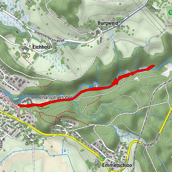
Wetzikon, Zürich
Hiking
Bookmark
Map
show
hide
Print
Tour data
2.26
km
588 - 596
m
Distance
8
hm
2
hm
Ascent
00:50
h
Duration
Kuti Dénes
created am 03.11.2019
356
Views
Route
Wetzikon
(535 m)
town
Chämptnertobel
locality
0.3 km
Grosser Giessen
waterfall
1.3 km
Highest point
596 m
Write a review
Overall rating
5
0
%
4
0
%
3
0
%
2
0
%
1
0
%
Reviews
(0)
0 Comments
Write a review
Error
An error has occurred. Please try again.
Thank you for your review
Rating has been deleted
Report tour
GPS Downloads
GPX
GPS Exchange Format (XML)
KML
Google Earth, Google Maps
QR Download Codes for Mobile Phones
Wetzikon, Zürich
QR Codes - tour download for cell phones
GPX
KML
Other tours in the regions
Schwyz
1748
Zürcher Oberland
596
Bäretswil
209
Popular tours in the area
Kollbrunn – Tüfels Chilen – Kollbrunn: «Mystisches Tobel»
easy
Hiking
7.66
km |
124
hm |
02:10
h
Hulftegg – Allenwinden – Hulftegg «Hulftegg Rundweg»
easy
Hiking
7.53
km |
147
hm |
02:00
h
Girenbad – Bachtel: «Wanderung am Bachtel für Gross und Klein»
medium
Hiking
9.27
km |
442
hm |
03:05
h
Wald – Bachtel – Wald: «Genussvoll wandern»
medium
Hiking
10.29
km |
486
hm |
03:30
h
No entries found.
The search is currently not available.
Please refine your search.
Local search results
(<= 25km)
More results
(> 25km)
%count% Search results
%name%
%type%
%elevation%
%population%
%lpButton%