© Pays du St-Bernard - Chloé Duay

© Pays du St-Bernard - Chloé Duay


- Difficulty
-
medium
- Rating
-
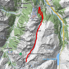
- Starting point
-
Barrage des Toules, Bourg-St-Pierre
- Best season
-
JanFebMarAprMayJunJulAugSepOctNovDec
- Description
-
A 3h30 hike in the heart of nature through the Combe des Planards.
- Directions
-
Departure from Bourg-St-Pierre.
At the start of the Toules dam, take the carriage road that rises towards the top of the dam wall. Continue above the Lettaz mountain pasture. The path then climbs on the summits of the mountain pasture of Fournoutze up to the gouille du Dragon. From the latter, a section on the ridge will take you to the Pointe des Planards for a magnificent view of the Combe de l'A.
- Highest point
- 2,864 m
- Endpoint
-
Pointe des Planards
- Height profile
-
 © outdooractive.com
 - Equipment
-
Good walking shoes, sticks.
- Tips
-
Keep your eyes and ears open: many marmots live in the Combe!
- Directions
-
Exit the motorway at Martigny.
Follow the direction Grand-Saint-Bernard to Boutg-St-Pierre.
- Public transportation
- Parking
-
Free parking in front of the house.


- Author
-
The tour Pointe des Planards is used by outdooractive.com provided.
GPS Downloads


General info
Healthy climate
Fauna
A lot of view
Other tours in the regions
-
Unterwallis
1192
-
Pays du Saint-Bernard
323
-
Bourg-St-Pierre
96