


- Brief description
-
From the Vallon de Van up to and around the idyllic Lac de Salanfe at the foot of the Dents du Midi. The trail leads through wild and alpine, fascinating landscapes.
- Difficulty
-
difficult
- Rating
-
- Starting point
-
Van d’en Haut campsite
- Route
-
La fontaine des bouquetins0.6 kmLa fontaine des bouquetins12.2 km
- Best season
-
JanFebMarAprMayJunJulAugSepOctNovDec
- Description
-
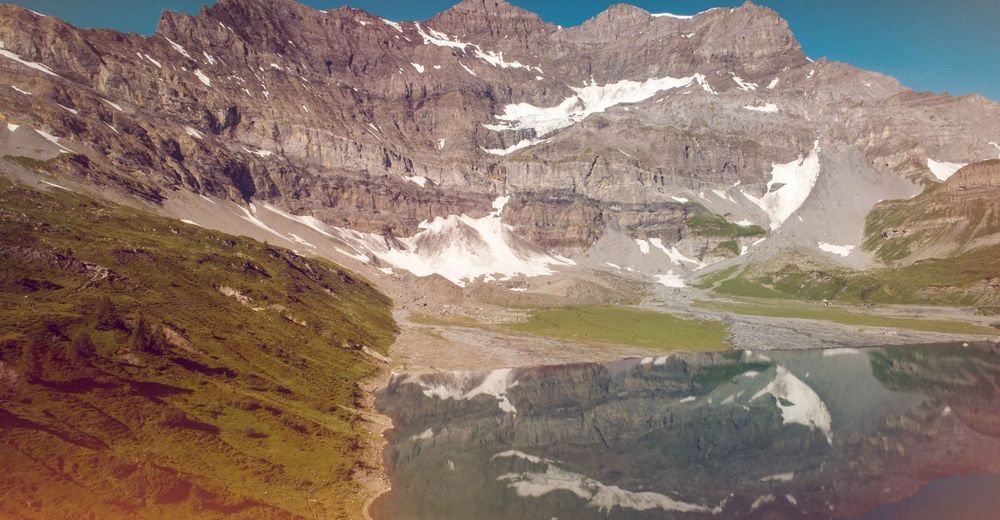
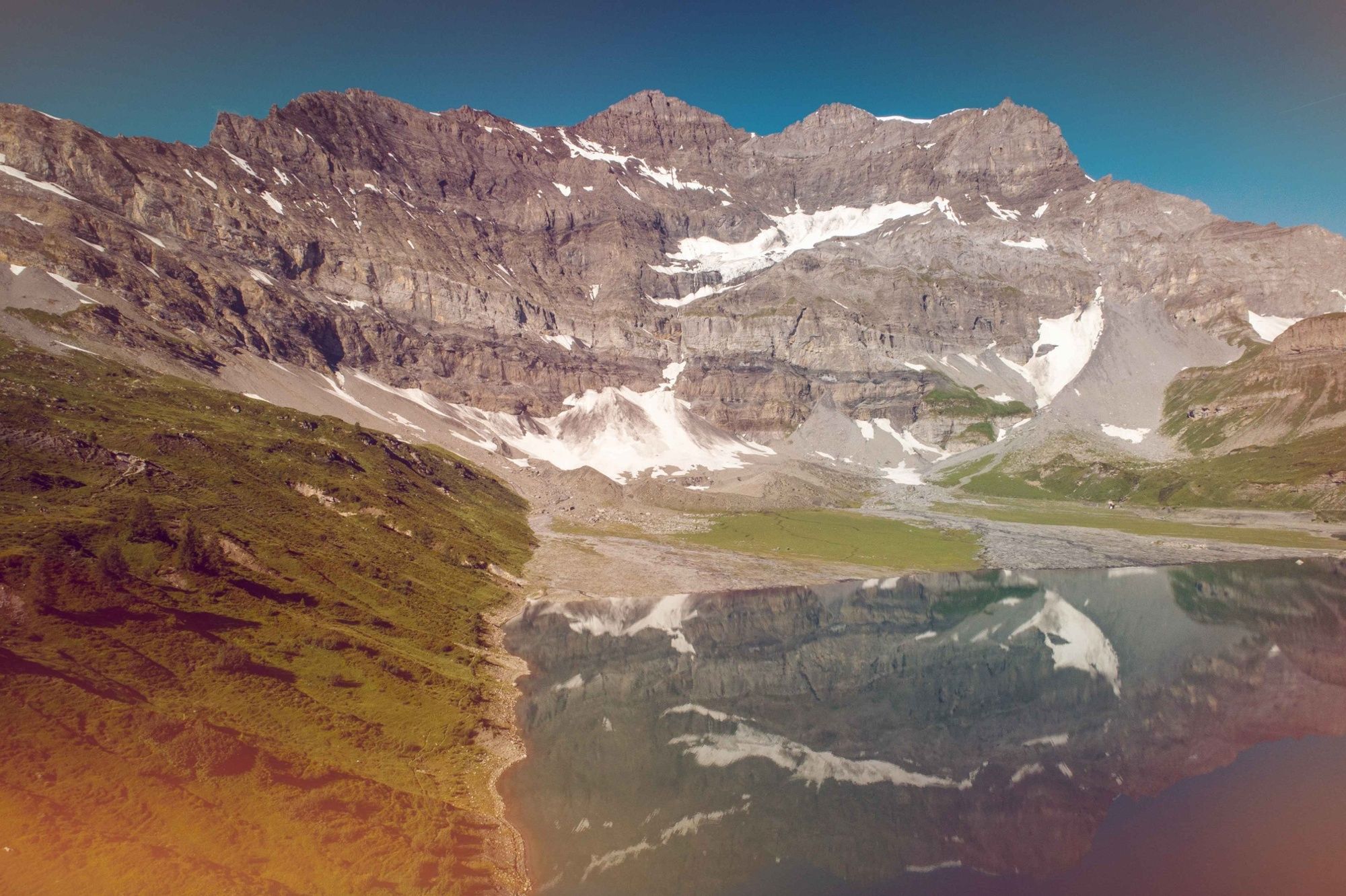
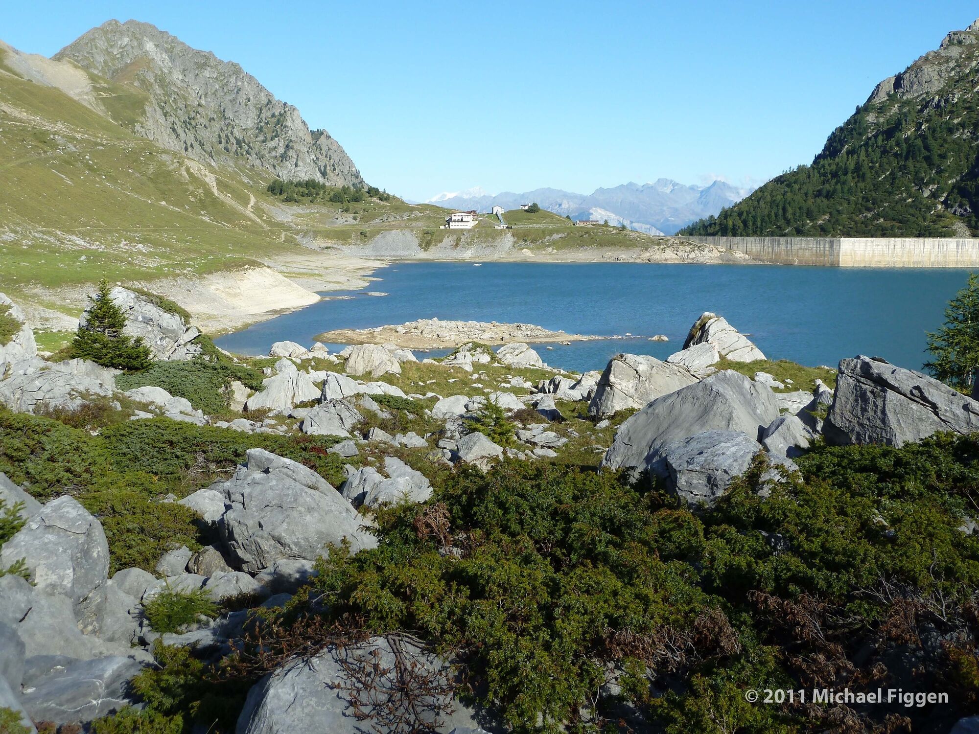
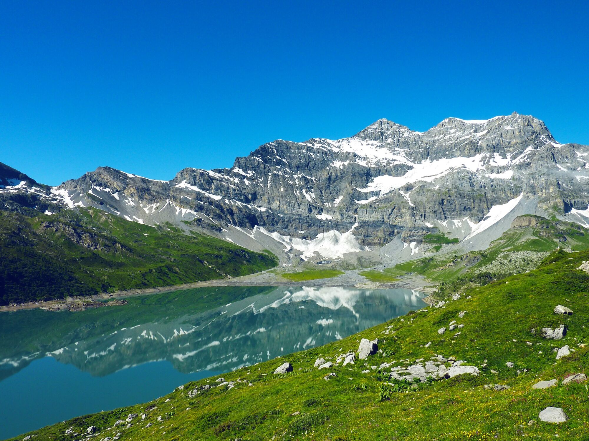
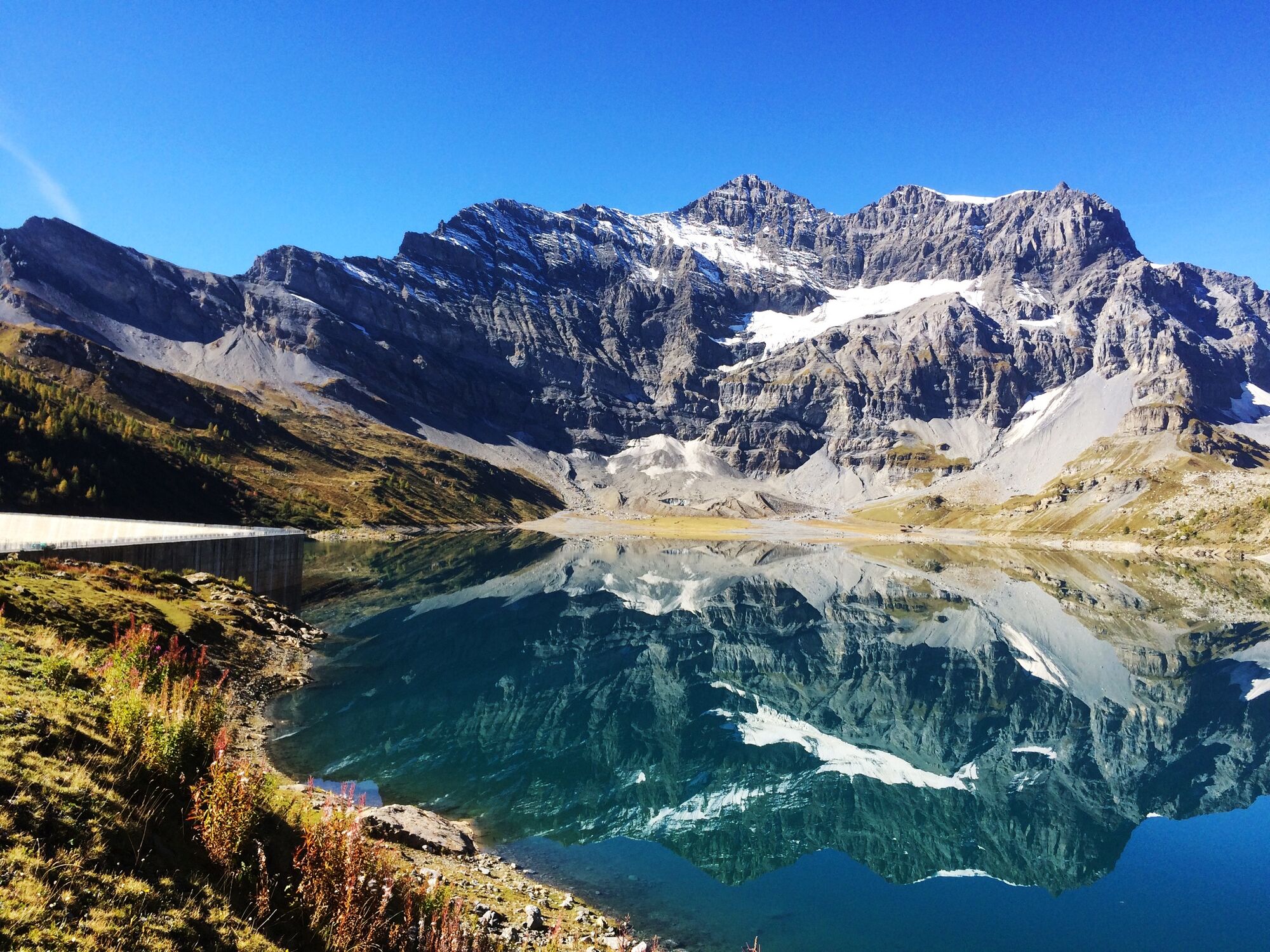
The Lac de Salanfe is a high-altitude reservoir (1,909 m) with a dramatic setting and a fascinating history.
The hike begins at the end of the public road in the idyllic Vallon de Van, and starts with a steep climb through the upper reaches of the valley to the Salanfe dam. The reservoir beyond occupies the floor of a vast glacial bowl, framed by the serrated pinnacles of the Dents du Midi and the dramatic Tour Sallière.
As it leads around the lake, the trail offers a thrilling experience of a high-altitude landscape, with a wealth of alpine flora and fauna. Highlights include surreal rock formations and a magnificent natural delta at the far end of the lake dominated by the hanging glacier of the Glacier Noir, high up on the Tour Sallière.
The landscape is blissfully peaceful now, but in the early 20th century the southern slopes of the bowl were a hive of activity, thanks to underground deposits of arsenic rich in gold. Between 1904 and 1907, miners extracted 23.8 tons of gold here – plus another 30-odd tons during the 1920s.
The trail completes its loop of the lake before redescending the Vallon de Van to the start of the walk.
Highlights
Bracing climb through the upper Vallon de Van Lac de Salanfe – alpine lake in a spectacular mountain bowl Auberge de la Salanfe – friendly restaurant/refuge overlooking reservoir, panoramic terrace. - Directions
-
Start at the Van d’en Haut campsite (“Camping de Van d’en Haut” – 1,393 m), and follow the path up the valley. Walkers who suffer from vertigo can avoid the steep flights of steps by switching instead to the former road used for construction of the dam. At the summit, set off around the reservoir anti-clockwise – with the option of stopping at the friendly Auberge de la Salanfe, just above the dam, for refreshments.
At the far end of the lake, cross the wide delta about mid-way between the shore and the glacial moraine to best negotiate the various branches of the river. The trail then gently climbs the slopes south of the lake, before going back to the dam. Beyond, drop back down into the Vallon de Van to return to the campsite.
- Highest point
- 1,979 m
- Endpoint
-
Van d’en Haut campsite
- Height profile
-
 © outdooractive.com
 - Equipment
-
We recommend:
good footwear clothing suitable for the weather: always carry a waterproof jacket hat or cap sunscreen bottle for water picnic camera binoculars (optional) hiking poles (optional) printout of this hike (click “Print” icon, to download)For certain walks:
Swimwear - Safety instructions
-
Use of the trails and the information on this website is at hikers’ own risk. Local conditions may entail changes to routes. Valais/Wallis Promotion accepts no liability for the accuracy and completeness of information on this website.
For all hikes:
Bring a map. Download full description of this route including large-scale map by clicking on “Print” icon, top right of this page. Use marked trails only, and observe all signposting – for your own safety, to safeguard grazing animals and to avoid disturbing wildlife. Close gates after passing through. Please be considerate to other trail users, and to the plants and animals. Do not leave any waste in nature.For mountain hikes:
Take extra care protecting yourself from the sun at altitude. UV radiation can be exceptionally strong, even in cloudy weather. Plan hike carefully: take into consideration fitness level of each participant, weather forecast and season. Weather conditions can change quickly in the mountains, without warning. Appropriate clothing is therefore essential, along with adequate supplies of food and water. In uncertain weather, turn back in good time.For high-altitude hikes:
Inform others of the route you plan to take. Whenever possible, avoid going alone. Do not venture onto glaciers without a mountain guide. Take note of the warning signs that point out the constant danger in river beds and along watercourses below dams and reservoirs: water levels may rise rapidly without warning. - Tips
-
In the upper Vallon de Van, opt for the former dam road in at least one direction to see “Moses’ fountain”, a natural spring.
- Additional information
- Directions
-
A9 motorway, exit 21 (Martigny-Fully), follow sings for Martigny. After about 1 km, pass under railway line and at roundabout immediately afterwards turn right, following signs for Vernayaz. About 700 m from roundabout, branch left, following signs for Salvan, then Les Granges and then Vallon de Van. Continue to the far end of the valley, where there is a car park at the entrance to the campsite.
- Public transportation
-
Train to Martigny; change to Mont-Blanc Express as far as Les Marécottes. From here, take postal bus to the Van d’en Haut campsite.
Find full timetable information at cff.ch
- Parking
-
Van d’en Haut campsite

-

-
AuthorThe tour Sentier de Salanfe is used by outdooractive.com provided.


General info
-
Portes du Soleil
970
-
Trient-Tal / Wallis
494
-
Les Marécottes
142