- Brief description
-
Pleasant walk through the fôret des Morasses forest
- Difficulty
-
easy
- Rating
-
- Starting point
-
A l'arrêt du bus en face du restaurant des Mélèzes
- Route
-
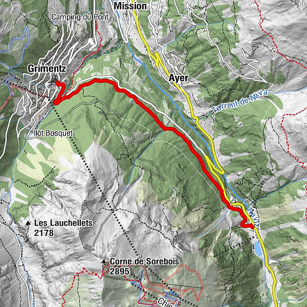
Grimentz (1,564 m)Mottec5.4 km
- Best season
-
AugSepOctNovDecJanFebMarAprMayJunJul
- Description
-
This pleasant, easy hike takes around 2 hours and covers 5.6 km. It takes you from the village de Grimentz to Mottec via the Morasses forest. The first part follows the road, so watch out for traffic. After around 10 minutes you’ll find yourself walking through the peace and quiet of the forest.
- Directions
-
Take the road in the direction of Zinal. Once you reach the bridge, continue on the road for about 100m, then take the path that rises on the right leading into the forest. This path goes directly to Mottec. It is possible to return from there to Grimentz on a free shuttle bus.
- Highest point
- 1,594 m
- Endpoint
-
Centre du village de Mottec
- Height profile
-
 © outdooractive.com
 - Equipment
-
Good, waterproof footwear
Snowshoes
Hiking poles
Warm winter clothing appropriate for the weather - Safety instructions
-
Tourist Offices cannot be held responsible in the case of accidents. For your safety, check the weather and snow conditions before setting out on these trails. Observe the signs and prohibitions (piste closures and risk of avalanche). If you are not suf ficiently knowledgeable to choose your trail according to your ability, you are strongly advised to hire a professional guide.
- Tips
-
You can take a free shuttle bus back from Mottec to Grimentz. The bus schedule is available at Tourist Offices.
- Author
-
The tour Grimentz - Mottec n°4 is used by outdooractive.com provided.