- Brief description
-
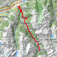
This climb in the heart of the central Valais from Sierre to the Mayen de Colombire will take you first on a journey to discover the sunny slopes of the right bank of the Rhone before heading up towards Aminona then the Col de Crans-Montana where a panoramic view will take your breath away.
- Difficulty
-
difficult
- Rating
-
- Starting point
-
Sierre
- Route
-
Siders (533 m)0.0 kmRionda1.9 kmVeyras (645 m)3.0 kmVenthen (799 m)5.0 kmConzor7.0 kmSaint-Maurice-de-Laques7.9 kmLa mi-côte8.4 kmMollens (1,070 m)8.5 kmAminona12.8 kmMayen de la Cure14.0 km
- Best season
-
JanFebMarAprMayJunJulAugSepOctNovDec
- Description
-
Starting from Sierre – the sunniest city in Switzerland – the road climbs in the typical vineyards of the Rhone Valley. You pass through the small villages of Veyras then Venthône before gradually slipping into an environment more mountainous. The grade is very steady, leaving little respite, and the several shaded sections of the climb are refreshing and gladly welcomed in the summer when the sun floods the mountainside. After the resort of Aminona, the itinerary heads to the right and the road becomes more narrow. The final stretch brings you to the Col de Crans-Montana located in an area called Mayen de Colombire, providing you with a fantastic view of the Weisshorn.
- Directions
-
The first kilometres of this long climb of 17 kilometres between Sierre and the Col de Crans-Montana take place in the middle of the vineyards, through small villages typical of the region. After Venthône, you enter into groves of deciduous trees and eventually pine and larch trees take over. From Aminona, the panorama before you is perhaps one of the most spectacular of the Valais. Five summits of more than 4,000 metres of altitude stand on the side of the Rhone Valley, forming the imperial crown of the Valais: the Weisshorn, the Zinalrothorn, the Ober Gabelhorn, the Matterhorn, and the Dent Blanche. This sumptuous view will accompany you all the way to the summit where the restaurant of the Mayen de Colombire provides a well-deserved break!
- Highest point
- 1,801 m
- Endpoint
-
Col de Crans-Montana
- Height profile
-
 © outdooractive.com
 - Equipment
-
We recommend: bike in excellent working order, helmet, gloves and bell, clothing suitable for the weather (always carry a waterproof), food and drink.
- Safety instructions
-
Strictly respect the Swiss traffic rules. Please note that you are running the tour at your own risk and all liability is refused. Please be considerate to plants and animals. For your own safety, wear an helmet every time you ride a bike. Emergency numbers: 144 Ambulance / 117 Police / 1414 Helicopter Rescue (Rega).
- Tips
-
Visit the historical museaum at the "Hameau de Colombire" which is situated not far from the end of the tour in Aminona.
- Additional information
- Directions
-
From the A9 motorway from Lausanne or Sierre, take the Sierre Est (from Brig) or Sierre Ouest (from Lausanne) exit and access to the park + ride at the train station via Rue de la Plaine.
- Public transportation
-
Arrive in Sierre by train from all Swiss towns and cities (SBB) or by the regional trains running on the Simplon line between Brig and St. Gingolph.
- Parking
-
Park + Ride at Sierre train station. Please follow the local car park routeing in Sierre.

- Author
-
The tour Col de l'Aprilly – Legendary Mountain Passes is used by outdooractive.com provided.


General info
-
Thyon les Collons
118
-
Crans - Montana
89
-
Noble-Contrée
38