

- Brief description
-
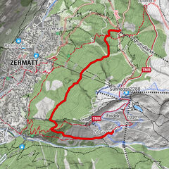
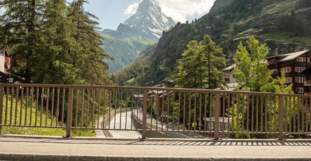
The village route is ideal for gentle sightseeing in the village of Zermatt and heads along easy roads to the best viewpoints, guaranteeing amazing views of the Matterhorn.
- Difficulty
-
easy
- Rating
-
- Starting point
-
Dorfplatz
- Route
-
Zermatt (1,608 m)0.1 kmSunneggabahn Talstation (1,604 m)0.5 kmKapelle der Heiligen Familie9.1 kmZermatt (1,620 m)9.7 kmKirche St. Mauritius10.5 km
- Best season
-
JanFebMarAprMayJunJulAugSepOctNovDec
- Description
-
The village route starts at the village square in the centre of Zermatt, located between Migros and the tennis court. The route heads along Wiestistrasse to Petit-Village, with lovely views of the village of the Zermatt and the majestic Matterhorn behind it. After enjoying the view, head via the village past Hotel Cervo to Restaurant Ried, a perfect place to stop for a rest and a bite to eat. Surrounded by the gentle rustling of the larch forests, the route then heads back into the village and up to the Winkelmatten area, where the small park near the chapel offers a different perspective of the Matterhorn. The benches are also perfect for another break. The route back to the starting point heads past the St. Mauritius parish church, through the English quarter and the old part of Zermatt village. It’s well worth climbing off by the ancient wooden houses and taking some time to admire the rural architecture.
Sightseeing Viewpoints Incredible views Route on paved roads only - Directions
-
Dorfplatz – Petit Village – Restaurant Ried – Chapel Winkelmatten – old part of the village - Dorfplatz
- Highest point
- 1,796 m
- Endpoint
-
Dorplatz
- Height profile
-
 © outdooractive.com
 - Equipment
-
We recommend:
Bike in excellent working order Helmet, gloves and (trail) bell Repair kit in case of any defects Clothing suitable for the weather (always carry a waterproof) Food and drink - Safety instructions
-
Always wear gloves and a helmet. Use marked bike trails and routes only, and observe all signposting. Please close gates after passing through. Please be considerate to walkers and to plants and animals. As a rule, walkers have priority. When planning, take into account participants’ fitness level and ability: some routes lead above 3,000 metres. All riding is at one’s own risk.
Tip: “Be searchable”. Equip yourself with an additional RECCO rescue reflector*. Whether summer or winter. Available in our Online-Shop or our information desk. *The additional reflector does not replace an avalanche beacon.
- Tips
-
To get the most out of sightseeing, it’s a good idea to do the route on an e-bike.
- Additional information
- Directions
-
Zermatt is car-free. Private vehicles are permitted only as far as Täsch (5 km before Zermatt). The Täsch–Zermatt road is closed to the public.
Onward travel to Zermatt is either by private taxi or shuttle train. Trains depart every 20 minutes; the journey takes about 12 minutes, and ends at the Bahnhofplatz in Zermatt.
- Public transportation
-
By train to the Matterhorn village: 3½ hours from Zürich airport or 4 hours from Geneva airport. Change at Visp onto the Matterhorn Gotthard Bahn (Matterhorn Gotthard Railway). From Visp, the railway leads through the Mattertal valley past idyllic small villages to Zermatt.
Zermatt is also the start and finish point for the world-famous Glacier Express panoramic train journey (Zermatt to St. Moritz or Davos).
- Parking
-
Täsch has car parks with both covered and open-air parking – e.g. at the Matterhorn Terminal or privately operated facilities.
Onward travel: see “Getting there”.

- Author
-
The tour Village Route Bike Tour (Nr. 66) is used by outdooractive.com provided.
General info
-
Oberwallis
211
-
Mattertal
62
-
Zermatt
35