
- Brief description
-
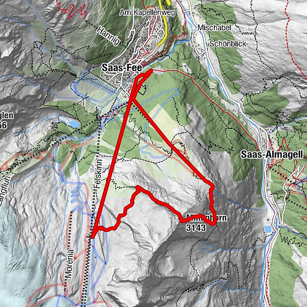
This via ferrata leads you to the top of Mittaghorn on 3143m. At the top, you are rewarded with a magnificent view from the heart of the Saas circle of 4000 m peaks. The Mittaghorn via ferrata is graded easy to medium.
- Difficulty
-
difficultDifficulty level B/C
- Rating
-
- Starting point
-
Valley station of the Alpin Express cable car
- Route
-
BlomattuSaas-Fee (1,798 m)Alpin Express I (1,798 m)0.0 kmChalmattu0.2 kmPlattjen (1,806 m)0.4 kmMittaghorn (3,143 m)5.5 kmPlattjen7.4 kmBergrestaurant Plattjen Terminus7.4 kmPlattjen7.5 kmChalmattu7.7 kmAm Biel10.3 kmSaas-Fee (1,798 m)10.3 kmBlomattu10.4 km
- Best season
-
JanFebMarAprMayJunJulAugSepOctNovDec
- Description
-
A mild to moderate via ferrata, which is also recommended to newcomers. The via ferrata follows the north-western ridge to the top. Arriving on top offers a breathtaking panoramic view on the surrounding 4000 metre peaks. Guided tours can be booked at the local mountain guides offices.
- Directions
-
The Alpin Express cable car carries you from Saas-Fee to the intermediate station of Morenia, about one-and-a-half hours’ walk from the start of the via ferrata. After a short section of path marked white-red-white, you reach an alpine trail marked white-blue-white. A flagpole then shows the beginning of the north-west ridge of the summit of the Mittaghorn. The subsequent climb brings you to an altitude of 2,800 m. The via ferrata leads over the rocks along the ridge as far as the summit of the Mittaghorn. For the descent, the trail takes you at first to the right, along the ridge, before a steeper descent towards the east. Follow the cairns down. After this steep descent, you reach the trail marked white-red-white leading to Plattjen. From here, you can take the gondola back down to Saas-Fee or hike down to Saas-Fee or Saas-Almagell.
- Highest point
- 3,124 m
- Endpoint
-
Mountain Staiton of the Plattjen cable car
- Exposition
- Height profile
-
 © outdooractive.com
 - Equipment
-
All climbers must wear a harness. Because of the risk of falling rocks along the route, a helmet is also essential. Ensure you have sturdy footwear and appropriate clothing, and bring a small rucksack with water and a snack. A suitable pair of gloves will protect your fingers and knuckles from grazes.
- Safety instructions
-
Weather conditions: before setting off to tackle a via ferrata, it is important to check the weather forecast. Bad conditions can make climbing dangerous – particularly in stormy weather.
Rockfalls: because of the risk of falling rocks – usually caused by climbers higher up or by animals – all climbers are strongly advised to wear a helmet.
Safety: always leave sufficient distance between yourself and the climber ahead. There should never be more than one person between two anchor points.
- Additional information
- Directions
-
From Basel/Zurich: Motorway A1 until Bern, A6 until Spiez, towards Kandersteg; Car transport Kandersteg-Goppenstein; towards Gampel - Visp - Saas-Fee. From Geneva: Motorway A1 until Lausanne; towards Sion/Sierre - Leuk - Visp - Saas-Fee.
- Public transportation
-
Trains from whole Switzerland to Visp. From there (southern exit of the train station), take the busses running to Saas-Fee.
- Parking
-
Saas-Fee is a car free destination. Use the parking at the entry of the village.

- Author
-
The tour Mittaghorn via ferrata is used by outdooractive.com provided.


General info
-
Oberwallis
38
-
Saastal
9
-
Saas-Fee
4