


- Brief description
-
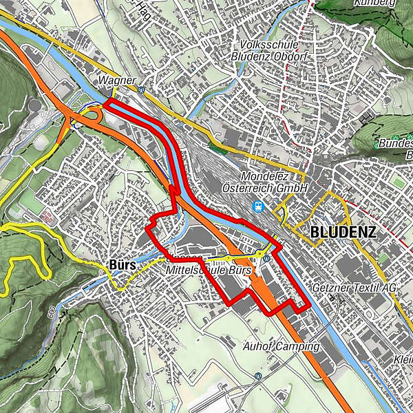
Leisurely walk through Bürs and along the Ill river.
- Difficulty
-
easy
- Rating
-
- Starting point
-
Zimbapark, Bürs
- Route
-
Bludenz1.0 kmFriedenskirche3.8 kmBürs3.9 km
- Best season
-
JanFebMarAprMayJunJulAugSepOctNovDec
- Description
-
The walk takes you along the Ill river through the municipality of Bürs. The start of the walk is at the Zimbapark. From here via the Almteilweg, continue over the motorway bridge to Bludenz. At the motorway police station, turn right into Bremschlstraße and then left at the Schrottenbaum carpentry workshop into Illstreet. Walk along the Ill until you reach the main road, then cross the pedestrian/cycle bridge, turn left and follow the cycle path until you reach the Quadrella pedestrian/cycle bridge, walk back along the Ill on the Bürser side - a short distance across the main road and then you are back at the starting point.
- Directions
-
Zimbapark - Almteilweg - freeway bridge - Bremschlstraße - Illstraße - Mokrystraße - Unterer Illrain - pedestrian/bicycle bridge Quadrella - Quadrella - Friedhofstraße - Schulstraße - Judavollastraße - Brandnerstraße - roundabout - Zimbapark
- Highest point
- 561 m
- Endpoint
-
Zimbapark, Bürs
- Height profile
-

- Equipment
-
Good shoes, rain and sun protection, filled water bottle. Mobile phone in case of emergency.
- Safety instructions
- Directions
-
google.maps.at
- Public transportation
- Parking
-
Zimbapark, Bürs

- Author
-
The tour Illweg | Bürs is used by outdooractive.com provided.


-
St. Gallen - Bodensee
2066
-
Alpenstadt Bludenz
1848
-
Bürs
489


