From Lech via the Bergbühne Spitzenegg and Wäldeleweg to Oberlech


- Brief description
-
From Lech via the Bergbühne Spitzenegg and Wäldeleweg to Oberlech.
- Difficulty
-
easy
- Rating
-
- Starting point
-
Hiking starting point Rüfiplatz
- Route
-
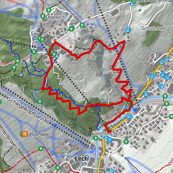
Lech (1,444 m)0.0 kmBergbahn Lech - Oberlech0.0 kmOberlech1.8 km
- Best season
-
JanFebMarAprMayJunJulAugSepOctNovDec
- Description
-
From the starting point at the Rüfiplatz, cross the old wooden bridge on the left side of the river downstream along the river Lech. After a few metres you will reach the main road and take the steep forest path uphill on the left. A few metres further on, a forest road branches off to the right and you follow uphill. At Hotel Formarin, turn left along the asphalt road until you reach Oberlech.
- Directions
-
Walk from the starting point at the Rüfiplatz. Cross the river Lech over the old wooden bridge and follow the Lech-Promenade down the river to the left until you reach the main road. After a few metres at the road on the left, a narrow forest road leads steeply uphill. After a few metres, another forest road branches off to the right, which you follow uphill to the Berg parcel. At Hotel Formarin, take the asphalt road on the left which leads into a hiking trail after a few metres. Follow this road until you reach Oberlech. Through Oberlech you follow the asphalted side road which becomes a forest path at the Hotel Petersboden. Follow the forest path downhill to the left and follow the trail. This trail leads through a light coniferous forest, which again and again offers magnificent views to Lech am Arlberg and back to the starting point.
- Highest point
- 1,636 m
- Endpoint
-
Oberlech
- Height profile
-

- Equipment
-
Good footwear (ankle high, profile sole), rain protection, Lech Card and bus timetable.
- Safety instructions
- Tips
-
Refreshment stop: restaurants in Lech or Oberlech
- Additional information
- Directions
-
From Germany: Take the A96 motorway to Bregenz from there on the A14 motorway to Bludenz, continue on the S16 to the Lech Zürs am Arlberg exit. Follow the B197 up to Alpe Rauz, turn left here onto the B198 through Flexengalerie and over the Flexenpass to Lech Zürs am Arlberg.
From Switzerland: Via the A13 motorway and the Feldkirch, Hohenems or Lustenau border crossing on the A14 motorway to Bludenz. Continue on the S16 until exit Lech Zürs am Arlberg. Follow the B197 up to Alpe Rauz, turn left here onto the B198 through Flexengalerie and over the Flexenpass to Lech Zürs am Arlberg.
From Austria: Via the Inntalautobahn A12 and then via the S16 to the exit St. Anton am Arlberg (Arlberg Pass). Follow the B197 first through St. Anton, then through St. Christoph and over the Arlbergpass to Alpe Rauz. Turn right here onto the B198, pass through Flexengalerie and continue to Zürs.
- Public transportation
- Parking
-
You can park your vehicle either directly at your host or at one of the day parking lots. Or in Lech am Arlberg in the Parkgarage Anger from 7:00 am to 8:00 pm.
-

-
AuthorThe tour From Lech via the Bergbühne Spitzenegg and Wäldeleweg to Oberlech is used by outdooractive.com provided.