- Brief description
- Difficulty
-
medium
- Rating
-
- Starting point
-
Old Bridge at the well
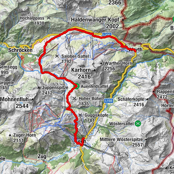
- Route
-
Lech (1,444 m)0.7 kmBergbahn Lech - Oberlech2.2 kmOberlech2.4 kmÜbungslift Oberlech2.8 kmUntere Auenfeldalpe6.5 kmHochkrumbach13.1 kmSennkuchl13.4 kmJägeralpe13.4 kmHolzbodenalpe14.1 kmWolfegg15.7 kmPfarrkirche St. Sebastian16.6 kmWarth (1,495 m)16.8 km
- Best season
-
JanFebMarAprMayJunJulAugSepOctNovDec
- Description
-
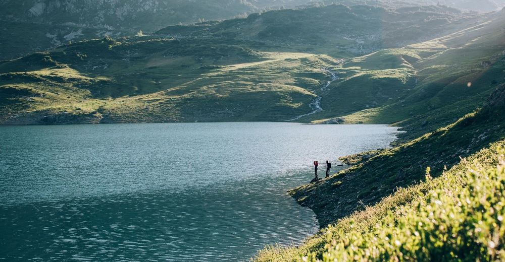
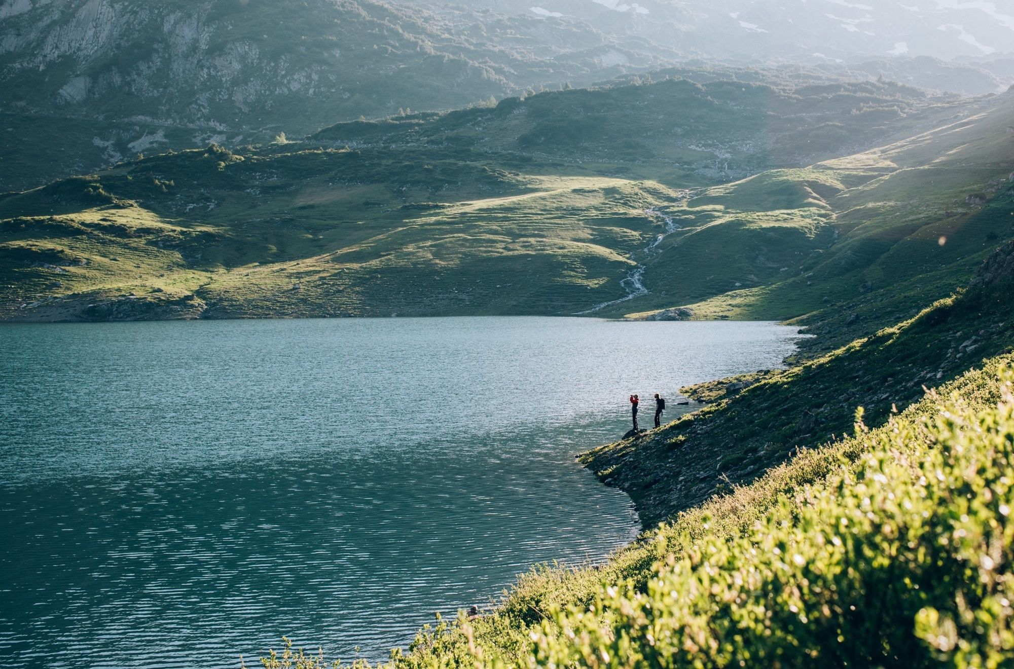
With this alternative to the 2nd stage of the Lechweg, the hiking trail leads from Lech via Oberlech past the landscape conservation area Gipslöcher through the floodplain field to Austria's most beautiful course: Lake Körbersee. This romantic place invites you to stay and relax - before continuing towards the Hochtannbergpass. On the old salt road they follow above the valley and finally reach the Walser village Warth. From there the blue hiking bus takes you back to Warth or you continue along the Lechweg on the 3rd stage to Tyrol.
- Directions
-
To the west you start following the signposted and asphalted path towards Oberlech. At the Oberlech mountain station, a path leads northwest towards Körbersee. The trail leads past the Hotel Mohnenfluh, crosses the centre of Oberlech and follows the asphalt road up to the left. On the plateau is the barbecue area. Here the path Groß Walserweg northwest through the Auensattel until you reach the fork after about 3 km. A sharp right turn leads through the lower Auenfeldalpe. To the left the Juppenspitze and Mohnenfluh, to the right the Karhorn in view. After about 30 minutes you reach the fork in the path, follow Großer Walserweg and follow the natural path Walserweg towards Körbersee. After about 15 minutes you reach a plateau with a view of the Körbersee. The shore path leads directly to the Körbersee restaurant. The ideal place to stop.
Behind the restaurant to the north, the broad, partly stony road leads uphill. After a few more, Lake Kalbelesee spreads out into the Hochtannberg Valley. The flat path from Hochtannberg leads north partly on the road and hiking trail to Hochkrumbach to Warth. - Highest point
- 1,789 m
- Endpoint
-
Warth
- Height profile
-

- Equipment
-
Good footwear (ankle-high, profile sole), rain cover, drink, snack, Lech Card and bus timetable.
- Safety instructions
-
NOTRUF:
140 Alpine emergencies throughout Austria
144 Alpine Emergencies Vorarlberg
112 Euro emergency call (works with any mobile phone/network)
www.vorarlberg.travel/sicherheitstipps
- Tips
-
The Körbersee lake captivates with its excellent drinking water quality, which provides a retreat for fish such as trout and special plants.
- Additional information
- Directions
-
From Germany: Take the A 96 to Bregenz from there on the A14 to Bludenz, continue on the S16 to the Lech Zürs am Arlberg exit. Follow the B197 to Alpe Rauz, turn left here onto the B198. Through the Flexengalerie and over the Flexenpass you reach Lech Zürs am Arlberg.
From Switzerland: Via the A13 and the Feldkirch, Hohenems or Lustenau border crossing onto the A14 as far as Bludenz. Continue on the S16 to the Lech Zürs am Arlberg exit. Follow the B197 to Alpe Rauz, turn left here onto the B198. Through the Flexengalerie and over the Flexenpass you reach Lech Zürs am Arlberg.
From Austria: Take the Inntal motorway A12 and then the S16 to the St. Anton am Arlberg exit (Arlbergpass). Follow the B197 first through St. Anton, then through St. Christoph and over the Arlberg Pass to Alpe Rauz. Turn right here onto the B198. Through the Flexengalerie and over the Flexenpass you reach Lech Zürs am Arlberg.
- Public transportation
-
Take the train to Langen am Arlberg or St. Anton am Arlberg station. From there, buses (no. 750+760) run at regular intervals to Lech Zürs am Arlberg. The hiking bus line 3 runs between Lech and Hochtannberg.
- Parking
-
You can park your car either directly with your host or in the underground car park Anger. The underground car park is located directly in the town centre opposite the Raiffeisenbank Lech.
-

-
AuthorThe tour Lechschleife 1 - On the tracks of the Walser on the Tannberg is used by outdooractive.com provided.