- Brief description
-
Au - on the cycle path to Bersbuch - Schwarzenberg - Bödele - Dornbirn - Achrain - Alberschwende - Müselbach - Langenegger Tobel - Langenegg - Lingenau - Großdorf - Egg - along the cycle path back to Au-Schoppernau.
- Difficulty
-
medium
- Rating
-
- Route
-
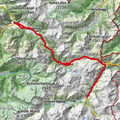
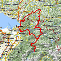
Au (800 m)0.2 kmLisse0.3 kmPfarrkirche Schnepfau5.2 kmSchnepfau5.3 kmHirschau7.3 kmKapelle Hl. Martin7.4 kmLourdeskapelle7.4 kmEnge8.7 kmTanna10.0 kmHinterbündt10.8 kmAchsiedlung10.9 kmNaze's Hus11.1 kmTempel11.2 kmMoos11.3 kmMellau11.3 kmPlatz11.3 kmPfarrkirche Mellau11.4 kmRistorante Pizzeria Sandro11.5 kmÜbermellen11.7 kmZimmerau11.9 kmIn der Mellen12.2 kmKlaus13.0 kmReuthe14.4 kmBaien15.6 kmHof16.4 kmZiegler (S-Line Gastronomie)19.5 kmLoch20.3 kmSchwarzenberg (696 m)21.3 kmPfarrkirche Schwarzenberg - Heiligste Dreifaltigkeit21.3 kmAdler21.3 kmHotel Gasthof Hirschen Schwarzenberg21.3 kmWeißtanne26.0 kmBödele26.6 kmBerghof Fetz27.0 kmAmmenegg29.5 kmAmmenegger Stuba29.6 kmRickatschwende30.1 kmOberdorf34.2 kmDornbirn (437 m)34.8 kmKapelle Kehlen35.8 kmHotel Hirschen36.8 kmWallfahrtskirche Maria Heimsuchung36.8 kmHaselstauden36.9 kmWinsau42.5 kmSchwarzen44.3 kmHof44.6 kmAlberschwende44.7 kmWirtshaus zur Taube44.9 kmWendelinkapelle45.0 kmZipfel45.1 kmBühel45.4 kmDresslen46.6 kmRestaurant Engel46.6 kmWälderstüble46.6 kmEngler Rank46.9 km300-7047.2 kmMüselbach50.3 kmGasthaus Sonne50.3 kmPfarrkirche Müselbach50.4 kmLangenegg54.6 kmOberlangenegg54.9 kmPfarrkirche Langenegg55.6 kmSt. Anna57.7 kmKapelle Heilige Anna auf dem Felde57.8 kmRain58.1 kmLingenau58.7 kmGasthof Adler60.3 kmGasthaus Falken60.4 kmGroßdorf60.5 kmEgg61.9 kmWasserfälle Brühlbach63.7 kmWasserfälle Brühlbach63.9 kmPfarrkirche Andelsbuch64.9 kmAndelsbuch64.9 kmPizzeria La Montanara65.2 kmUnterbezegg66.2 kmGasthof Adler66.3 kmBersbuch (634 m)68.1 kmSchwarzenberg (636 m)68.6 kmZiegler (S-Line Gastronomie)68.7 kmHof71.8 kmBaien73.0 kmReuthe74.2 kmKlaus75.6 kmIn der Mellen76.4 kmZimmerau76.8 kmHirschlitten77.2 kmRistorante Pizzeria Sandro77.2 kmPlatz77.3 kmÜbermellen77.3 kmPfarrkirche Mellau77.4 kmMellau77.4 kmMoos77.4 kmNaze's Hus77.5 kmTempel77.6 kmAchsiedlung77.8 kmHinterbündt77.9 kmTanna78.6 kmEnge79.7 kmLourdeskapelle81.2 kmKapelle Hl. Martin81.2 kmHirschau81.3 kmSchnepfau83.4 kmPfarrkirche Schnepfau83.4 kmAu (800 m)88.4 kmLisse88.4 km
- Best season
-
JanFebMarAprMayJunJulAugSepOctNovDec
- Description
-
Take the Bregenzerwald cycle path as far as Bersbuch. Turn off towards Schwarzenberg at the roundabout. In the historically lovely centre of the village of Schwarzenberg, turn off to the left towards the Bödele. The Bödele, also known as the Losenpass, awaits with a difference in altitude of 450 m over 5.7 km. The Bödele represents the direct connection between Dornbirn in the Rhine Valley and the Bregenzerwald. The view is also fantastic, and definitely worth taking a break to enjoy. After the downhill run to Dornbirn, turn off to the right at the edge of town at Gasthaus Engel. Continue as far as Haselstaudenstraße, turn off to the right and, at the crossroads, turn off to the right once again. Follow the L 49 as far as Alberschwende. Distant views across Lake Constance open up. In the centre of Alberschwende, turn off to the right at the crossroads, take the L 200 as far as Müselbach. There, turn off to the left and, after 50 m, turn off to the right towards the centre of Müselbach. Now comes a windy downhill run on a narrow road as far as the bottom of the valley of the Bregenzerache before the road goes back up to Langenegg. At the entry to the main road, turn off to the right and take the road as far as Lingenau. Approx. 200 m after the thermal baths, turn left at the crossroads and, after 50 m, turn right into a narrow street. Take the link road until you join the L 29 towards Egg-Großdorf. In Egg, take the Bregenzerwald cycle path back to the starting point in Au-Schoppernau.
- Highest point
- 1,138 m
- Endpoint
-
Gemeindeamt Au/Alpenhotel Post
- Height profile
-


-

-
AuthorThe tour Au-Schoppernau | Bödele - Achrain is used by outdooractive.com provided.


-
St. Gallen - Bodensee
31
-
Bregenzerwald
52
-
Andelsbuch
29