- Brief description
-
This scenic tour with views of the Rhine Valley inspires numerous mountain bikers!
- Difficulty
-
difficult
- Rating
-
- Starting point
-
Alpe Rona, Bürserberg
- Route
-
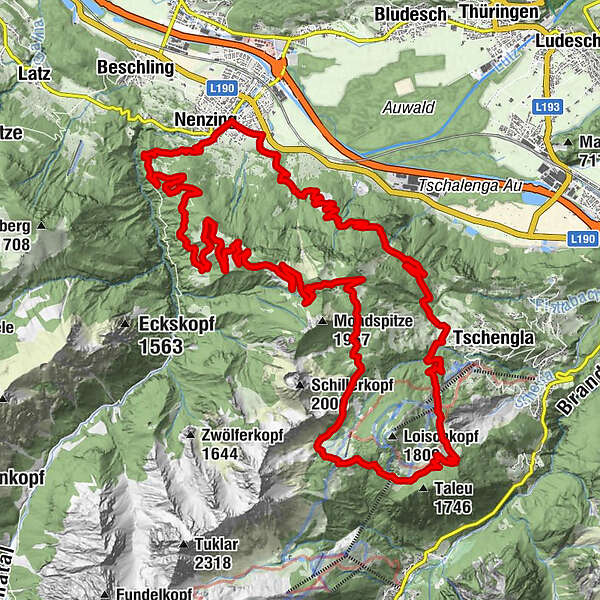
Nenzing9.5 kmStellveder11.8 kmParpfienzsattel (1,675 m)29.2 kmFrööd30.4 kmBurtschaalpe32.6 kmFuchsbau33.5 kmRonaalpe35.9 km
- Best season
-
JanFebMarAprMayJunJulAugSepOctNovDec
- Description
-
This tour starts at the Alpe Rona on the Tschengla high plateau. From there head west on the Plandedonweg via the Güterweg to Nenzing. In Nenzing follow the Meng to the left in the direction of Stellfeder or Nenzinger Himmel. In Stellfeder drive past the toll house in the direction of Nenzinger Himmel. After about 600 m turn left and drive uphill in many bends towards Nenzingerberg Alpe. From there a last ascent to the Klampera Fürkele. From the Fürkele you now continue over the Furkla Alpe to the Parpfienzsattel. Here you turn left and walk over the Burtschasattel and the Burtscha Alpe back to the high plateau Tschengla to the starting point.
Option
The tour can, of course, also be started in Nenzing or shortened a bit by taking the Alte Statt path from the Parpfienzsattel back to the Alpe Rona.
Bike & Hike
This tour is also suitable as a Bike & Hike tour. From the Klampera Fürkele you can climb in about 30 minutes to the summit of the Mondspitze and enjoy a fabulous view over the surrounding valleys.
- Directions
-
Alpe Rona - Plandedon - Nenzing - Stellfeder - Nenzingerberg - Nenzingerberg Alpe - Klampera Fürkle - Furkla Alpe - Parpfienzsattel - Burtschasattel - Burtscha Alpe - high plateau Tschengla - Alpe Rona
- Highest point
- 1,715 m
- Endpoint
-
Alpe Rona, Bürserberg
- Height profile
-

- Equipment
-
Mountain bike, helmet, rain or sun protection, small snacks and enough water to drink. Mobile phone in case of emergency.
- Safety instructions
- Arrival
- Public transportation
- Parking
-
Parking space at high plateau Tschengla


- Author
-
The tour Nenzingerberg Tour | Bürserberg-Nenzing is used by outdooractive.com provided.


General info
-
St. Gallen - Bodensee
156
-
Brandnertal
210
-
Nenzing
52

")