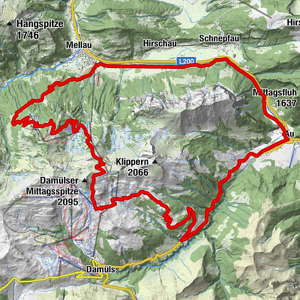
Mellau - Damüls

Logo Mellau - Damüls
Tour data
35.61km
685 - 1,910m
Distance
1,584hm
1,559hm
Ascent
03:30h
 
Duration
Brief description

Mountainbiketour von Mellau der Schistrecke entlang nach Damüls

Difficulty
difficult
Rating
Technique
Fitness
Landscape
Experience
Starting point

Bergbahnen Mellau

Route
Prinzwies
0.7 km
Schönboden
1.6 km
Alpe Uga
13.5 km
Uga Alp
13.5 km
Vordere Ugaalpe
13.8 km
Argenzipfel
26.1 km
Au (800 m)
26.8 km
Lisse
27.0 km
Bühlenvorsäß
30.5 km
Schnepfau
31.0 km
Brand
34.5 km


Best season
Jan
Feb
Mar
Apr
May
Jun
Jul
Aug
Sep
Oct
Nov
Dec
Highest point
1,910 m
Endpoint

Bergbahnen Mellau


Rest/Retreat

Rossstelle


Overall rating

5

0

%

4

0

%

3

0

%

2

0

%

1

0

%

Error
An error has occurred. Please try again.
Thank you for your review

Rating has been deleted

GPS Downloads
  • GPX GPS Exchange Format (XML)
  • KML Google Earth, Google Maps
QR Download Codes for Mobile Phones

Surfaces

Asphalt (20%)
Gravel (70%)
Forest
Mountain paths
Single trails (10%)
Trial
Traffic
Other tours in the regions

Popular tours in the area

Mellau - Mellental - Rossstelle - Au - Mellau

medium Mountainbike
40.51km | 1285hm | 03:00h

Stuben - Lech - Zugertal - Formarinsee - Steinbockweg - Dalaas - St...

difficult Mountainbike
48.28km | 1270hm | 06:30h

Spullersee Tour

medium Mountainbike
25.41km | 626hm | 02:30h

Bike & Hike Geißhorn (2.366 m)

difficult Mountainbike
24.81km | 1053hm | 04:15h