
- Brief description
-
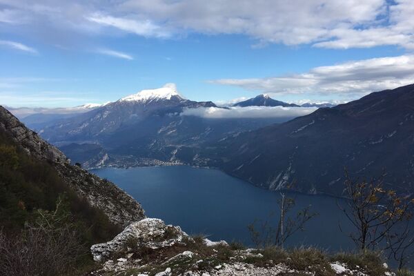
Ponale Trail is the best known and most popular in Garda Trentino: easy but at the same time spectacular as its winds sheer above the lake, a classic trek you can't afford to miss.
- Difficulty
-
easy
- Rating
-
- Starting point
-
Via Monte Oro - Riva del Garda
- Route
-
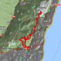
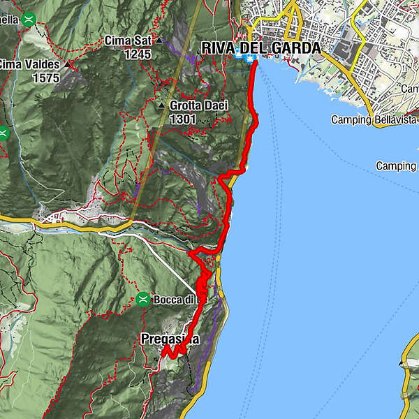
Riva del GardaCascata del Ponale2.9 kmPonale Alto (Belvedere)2.9 kmLe Zette3.0 kmLa Calchera4.0 kmAlbergo Rosalpina5.8 kmPregasina6.2 kmAlbergo Panorama6.2 kmChiesa di San Giorgio6.3 km
- Best season
-
JanFebMarAprMayJunJulAugSepOctNovDec
- Description
-
The line of the Old Ponale Road stands out against the mountainside and is clearly visible from the beaches in Riva and Torbole. The Ponale trail is an icon of Garda Trentino, much loved by visitors and locals alike who never tire of the spectacular views it offers at every bend.
The Ponale Road was opened to road traffic at the end of the 80s with the opening of the new tunnel to Valle di Ledro which was subsequently turned into a cycle path in 2004.
The Ponale Road is famous not only for the unequalled panorama of the lake but also for the military installations you can see along the trail. When you come to the second and third tunnels you can see remains of the Tagliata del Ponale, imposing fortifications built by the Austro-Hungarians from 1860 onwards which consist of tunnels excavated into the rock and trenches which stretch from lake level to the outposts overlooking the current trail. Today the Tagliata complex is normally closed to the public for reasons of safety.
- Directions
-
From the hydroelectric power station of Riva del Garda, head south. The start of the trail is just before the tunnel, on the left. This trail winds sheer above the waters of the lake and there are breathtaking views at every bend.
The first part of the hike finishes at Belvedere (now a stop-off point for refreshments during the summer season). If you wish, you can finish the excursion here and head back the way you came to Riva.
Otherwise, you can choose to continue on up to the right towards Valle di Ledro and its lake or else head left until you come to Pregasina. Here you can stop off for something to eat and drink before heading back along the same trail or else by public transport (bus stop ist about 3 km from Pregasina).
You can also hike the Sentiero del Ponale in the opposite direction, starting from Biacesa in Valle di Ledro. Another option is to start at Lake Ledro and follow the torrent Ponale downhill to the start of the Sentiero del Ponale proper.
- Highest point
- 527 m
- Endpoint
-
Pregasina
- Height profile
-
 © outdooractive.com
 - Equipment
-
You need to wear the right clothing and take the proper gear when you go hiking in the mountains. Even on relatively short easy outings make sure to take all you need so you don't run into trouble if things take an unexpected turn, for example a storm blows up or you have a sudden drop in energy levels.
What should you take when you go on a hike?
Your rucksack (for a day trip a 25/30L capacity should do) should contain:
water canteen (1L) snacks (e.g. mixed dried fruit or chocolate) First aid kit windproof jacket fleece change of t-shirt and socks (in a plastic bag) make sure to wear or at least bring a pair of long trousers hat sun screen sunglasses gloves whistle to attract attention in an emergencyMake sure you're wearing the right footwear for the trail and season. The going can get rough and rocky underfoot and a pair of hiking boots will protect you from sprains. When wet, a grassy slope, rocky slab or steep trail can be dangerous unless you are wearing the proper footwear.
And finally... don't forget to bring your camera! You'll need it to capture the stunning views you come across all over Garda Trentino. And if you like, you can share your memories with us at #GardaTrentino.
Emergency telephone number 112.
- Safety instructions
-
The Ponale trail is an alpine trail for expert hikers which runs close to a rockyand impervious wall and should be treated with all the necessary attention and appropriateclothing. This trail is shared by hikers and bikers: it is recommended that both follow the respectivelanes. The route is not recommended for prams; dogs are allowed as long as they arekept on a leash.
Warning! The trail presents no technical difficulties but is prone to rock falls!
Safety Tips
Choose itineraries that suit your physical and technical abilities. Collect information about the area you are visiting and the trail’s conditions and get a detailed trekking map. Wear clothes and take equipment that suit the difficulty and length of your tour. Keep emergency gear in your rucksack, including first aid supplies. Do not go walking alone in the mountains. In any case, tell someone where you are going and report back on returning. Look at the weather forecast before setting off and always keep an eye on the weather. In case of doubt, go back. It is better to give up than risk bad weather or face difficulties beyond your strength, ability and equipment. Do not leave marked paths and do not take shortcuts. All described walks are in a natural environment and therefore their use is at your own risk.This information is subject to inevitable variations, so none of these indications are absolute. It is not entirely possible to avoid giving inexact or imprecise information, given how quickly environmental and weather conditions can change. For this reason, we decline any responsibility for changes which the user may encounter. In any case, it is advisable to check environment and weather conditions before setting out.
- Tips
-
Ponale Road was begun in 1851, an ambitious project to link Lake Garda and Lake Ledro which up till then had been cut off from the rest of Trentino
- Additional information
- Directions
- Public transportation
-
The main towns in Garda Trentino - Riva del Garda, Arco, Torbole sul Garda, Nago – are connected by several urban and intercity bus lines which will take you to the starting point of tours or in the immediate surroundings.
You can also get to Riva del Garda and Torbole sul Garda by the public ferry service.
To get back to where you started from, you can take the bus line 214 (Riva del Garda - Valle di Ledro), getting on at the bus stop in Pregasina junction along the main road SS240 (which you can get to after the Belvedere by heading up to the right along a series of switchback bends).
Up-to-date information on timetables and routes.
- Parking
-
Parking near the former hospital (Via Rosmini) or the former cemetery (Viale Damiano Chiesa).
Paid parking: Terme Romane (Viale Roma), Vecchia stazione (Largo Medaglie d’Oro), Ex-agraria (Via Lutti), Area ex-Cattoi (Viale Rovereto).


-
-
AuthorThe tour Sentiero del Ponale (from Riva del Garda) is used by outdooractive.com provided.


General info
-
Gardasee / Lombardei
437
-
Garda Trentino
666
-
Riva del Garda
305