- Brief description
-
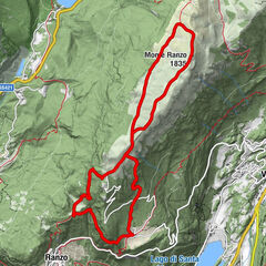
Hike round the Calisio Mount with its views on Adige Valley
- Difficulty
-
medium
- Rating
-
- Starting point
-
Villamontagna (570 m)
- Route
-
Villamontagna0.0 kmChiogna (541 m)0.3 kmTavernaro0.3 kmPez (557 m)1.0 kmTrient (194 m)1.2 kmStoi Belvedere (1,030 m)3.2 kmMonte Calisio (1,096 m)3.5 kmCarbonaia (861 m)5.4 kmPineta di Campel6.9 kmCampel (733 m)7.1 kmVillamontagna8.0 kmTavernaro8.1 km
- Best season
-
JanFebMarAprMayJunJulAugSepOctNovDec
- Description
-
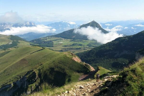
The peak of Monte Calisio offers a fabulous panoramic view of Valle dell’Adige and of part of Valsugana. This route carries out a summit circular trek utilizing the charming trails No. 402 and No. 403A. The itinerary goes past Rifugio Campel, a natural rest stop for this excursion.
- Directions
-
From the roundabout of Villamontagna go downhill along the tarmac road that crosses through the small inhabited area and continues towards Tavernaro. It is possible to walk below the village and enjoy the beautiful view of Monte Bondone standing high above the Trento basin.
After having gone downhill for about 600 m you will reach a crossroads in the road (SAT sign), go to the right slightly uphill on the tarmac road. Follow this road through the countryside. The view of Trento and of Monte Bondone is magnificent.
Continuing in this direction you will reach Pez (557 m). Proceed on trail No. 402 in the direction of Calisio passing through Vason.
The trail starts to climb sharply. On this climb you will go through “Strada de Mez” at an altitude of 750 m. Briefly follow the path to the left and then turn right following the signs for trail No. 402. At an altitude of 860 m you will reach Stoi.
Cross the road and then go up along trail No. 402. This trail becomes steeper and more challenging as it winds up into the forest. Follow it up to the peak at an altitude of 1096 m. The panorama over the Valle dell’Adige is just wonderful.
For the return trek follow trail No. 403A that crosses over the mule track on the southern side. Following the signs for trail No. 403A, you will reach Rifugio Campel at an altitude of 733 m. This is a natural rest stop for this excursion. From the mountain hut go down following the signs for trail No. 421 (a tarmac path) to return quickly to the starting point.
- Highest point
- 1,072 m
- Endpoint
-
Villamontagna (570 m)
- Height profile
-
 © outdooractive.com
 - Equipment
-
Hiking shoes, rain-jacket, water, sun cream.
- Safety instructions
-
1) Prepare your itinerary
2) Choose a route that is suitable for your skill level
3) Choose suitable equipment and gear
4) Consult the snow/weather bulletins
5) Heading out on your own is more risky
6) Leave information on your itinerary and on the approximate time you expect to return
7) Do not hesitate to seek the support of a professional
8) Pay attention to the information and signs that you find along the trail
9) Do not hesitate to follow your steps backwards
10) In case of an accident, sound the alarm by calling the emergency number 112.
Please note that the practicability of the itineraries in a mountain environment is strictly linked to the contingent conditions and is therefore influenced by natural phenomena, environmental changes and weather conditions. For this reason, the information contained in this page may have changed. Before leaving for a tour, make sure the path you will approach is still accessible by contacting the owner of the mountain hut, the alpine guides or the visitor centres of the nature parks, the info offices of the local tourist board.
- Tips
-
There are no refreshment stations or drinking fountains on the summit, so bring drinks and food with you.
- Additional information
-
Trento Tourist Office - Tel. +39 0461 216000 - info@trento.info - www.trento.info
- Directions
-
Start on the national road Trento SS47 in the direction of Padova. At the first exit turn right in the direction of Cognola/Povo/Martignano. Follow the signs for Cognola. Go uphill through the town and then proceed towards Villamontagna which you will reach at an altitude of 570 m. Some parking spaces are available at the roundabout.
- Public transportation
-
From Trento, Piazza Dante take bus number 9 to Villamontagna.
- Parking
-
Parking at Villamontagna village.


- Author
-
The tour Monte Calisio trek is used by outdooractive.com provided.