
- Brief description
-
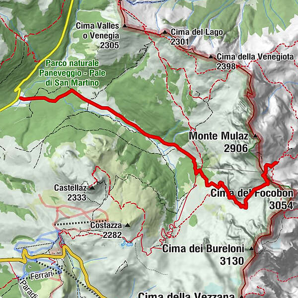
From the beautiful Val Venegia to one of the most inspiring mountain huts (rifugio) of the Pale di San Martino, following the trail dedicated to the alpine guide, Quinto Scalet.
- Difficulty
-
medium
- Rating
-
- Route
-
Agritur Malga Venegiota3.2 kmAgritur Malga Venegiota11.2 km
- Best season
-
JanFebMarAprMayJunJulAugSepOctNovDec
- Description
-
This panoramic route up to the Rifugio Mulàz "Giuseppe Volpi" climbs steeply up from the floor of the verdant Val Venegia along grassy slopes, across rocks and scree to the Mulàz Pass, in the heart of the northern sector of the Pala group.
- Directions
-
From the spacious car park of Pian del Casoni, go out onto the road. The start of the path is on the left of the dirt-track which links Malga Venegiota to Campigol della Vezzana. After a few metres, at the chalet of the service cable car for Rifugio Mulàz, you come to the fork of route 749 in the direction of the Passo Valles. Turn right and go up through the sparse larch wood towards the base of the Mulàz, passing the fork with route 710A which comes from Baita Segantini. As the view opens out onto the magnificent gravel-bed river which flows out onto the meadows below, you continue on through steep fields and scree, working your way up the tight turns along the slope, with the help in places of some steps carved out of the rock and cable handrails. When you reach the end of a rocky hollow, the trail veers sharply northwards, rising up at first onto a wide grassy shoulder and then, on rocky steps, scree and boulders, as far as the Mulàz Pass. From the pass, the route goes over the top and then down towards the Rifugio Mulàz "Giuseppe Volpi” which is close by.
- Highest point
- 2,615 m
- Endpoint
-
Pian dei Casoni (Val Venegia)
- Height profile
-
 © outdooractive.com
 - Equipment
-
Hiking boots
Mountain wear including windproof jacket and a change of underwear
Gloves and cap
Backpack and water bottle
Sleeping bag
Camera
Sun cream and sunglasses
Walking poles
- Safety instructions
-
Choose the route according to your experience and your physical preparation: start with short distances first!
The more, the merrier: leaving alone for a hike can be risky, travel with at least one other person, the experience of a Trekking is better when shared with friends and family!
Program your Trekking in advance, check trails and paths on the maps, have a look online to find out more about your itinerary, ask somebody who already walked the same route.
Prepare your backpack: have a look at our check-list to be sure you already packed all the equipment you may need during the Trekking!
Don’t forget to check the weather forecast.
If you really want to try the experience of a Trekking but you don’t feel ready to do it by your own, just ask one of our Alpine Guides!
Try to estimate an average journey-time of every route, considering the physical condition of each member of the group.
Inform the Hut owner or who is waiting for you at home about your time of arrival and the itinerary.
Keep your eyes open: while you’re walking, check the number of each footpath, but don’t forget to enjoy nature and its magic!
A plan B is always a good idea! Organize an alternative route in case of bad weather or unforeseen event: go back if it’s necessary, play it safe!
Please note that the practicability of the itineraries in a mountain environment is strictly linked to the contingent conditions and is therefore influenced by natural phenomena, environmental changes and weather conditions. For this reason, the information contained in this page may have changed. Before leaving for a tour, make sure the path you will approach is still accessible by contacting the owner of the mountain hut, the alpine guides or the visitor centres of the nature parks, the info offices of the local tourist board.
- Additional information
-
www.aquilesanmartino.com


-

-
AuthorThe tour Pian dei Casoni - Rifugio Volpi al Mulaz (Quinto Scalet trail) is used by outdooractive.com provided.


General info
-
Dolomiten
1826
-
San Martino di Castrozza
561
-
Passo Rolle
144