

- Brief description
-
A taxing roller coaster of a tour, both in terms of distance and its high gradient. Low volume traffic and characteristic landscape. The cycle path that goes from Ponte Arche to Sarche is amazing.
- Difficulty
-
medium
- Rating
-
- Starting point
-
Riva del Garda - Info office
- Route
-
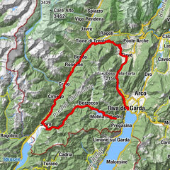
Riva del Garda0.2 kmChiesa di San Michele0.3 kmSan Giacomo1.8 kmDom2.1 kmEden Marone2.4 kmAlbergo Deva4.5 kmDeva4.5 kmTenno6.5 kmPranzo8.0 kmSorgente Seghe12.2 kmChiesa di Santa Lucia14.1 kmCorona Bar Ristorante14.1 kmBallino14.2 kmPizzeria Ristorante da Lucio14.3 kmDos18.3 kmChiesa di San Rocco19.0 kmAl Contrario19.3 kmFiavé19.5 kmChiesa dell'Immacolata e dei Santi Fabiano e Sebastiano19.5 kmAgritur Maso alle Rose22.0 kmCavrasto22.5 kmMarcè23.3 kmMarazzone24.0 kmCavaione24.3 kmPiazzale delle bore25.3 kmLocanda Ridevert32.8 kmGiugià32.8 kmZuclo32.9 kmPreore35.5 kmChiesa parrocchiale di Santa Maria Maddalena35.6 kmChiesa di San Faustino e Giovitta36.7 kmFevri37.2 kmBaltram37.3 kmRagoli37.3 kmChiesa parrocchiale di San Faustino37.3 kmVigo37.4 kmBolciana37.5 kmCappella dell'Addolorata38.0 kmColtura38.8 kmPez39.1 kmIncassero42.1 kmRio Bianco44.6 kmL'osteria45.3 kmChiesa di San Vigilio45.4 kmStenico45.4 kmSclemo48.1 kmAndogno50.8 kmTavodo51.0 kmDoss de Doa52.9 kmVilla Banale53.9 kmRistorante Bellavista54.0 kmMiravalle Sarche62.0 kmHosteria Toblino63.6 kmSarche63.8 kmPonte Oliveti64.8 kmPergolese66.7 kmOsteria da Gio70.3 kmDro76.6 kmCeniga77.9 kmMoletta80.5 kmPrabi81.0 kmSan Martino81.2 kmChiesa di San Giuseppe81.9 kmMogno81.9 kmArco82.5 kmBioessere83.4 kmI Sapori84.1 kmSan Tomaso84.8 kmChiesa di San Tomaso84.8 kmTop di gamma85.2 kmAlboletta86.5 kmRiva del Garda87.2 km
- Best season
-
JanFebMarAprMayJunJulAugSepOctNovDec
- Description
-
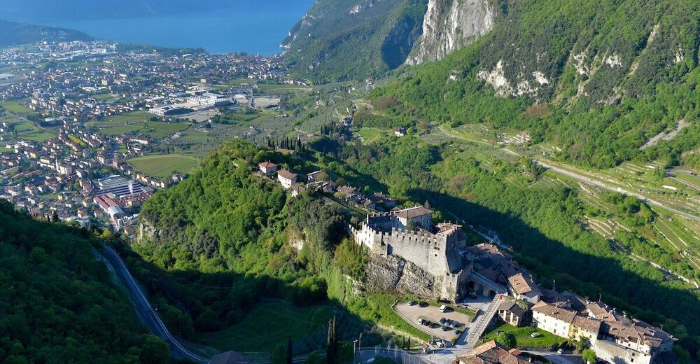
This itinerary proposes the climbs to the Ballino and Duron passes. They are not exceptionally tough but require an effort that untrained cyclists might pay a high price for in the second part of the tour. In fact, after these two challenging elements, we remain at an altitude and head for Stenico, a location mostly famous for its castle.
The road flattens out again thanks to the Limarò cycle path, a spectacular descent overlooking the cliff where the river Sarca flows. The last challenges of the day are the short sections in the area of Lake Cavedine, after which the route is exclusively downhill.
- Directions
-
Starting from Riva del Garda cycle up towards Pranzo, pass trough the village of Deva, until reaching the magnificent Lake Tenno.
Continue the uphill road to the Ballino Pass (750m) and then go downhill turning left at Fiavè and from here onwards take the direction of Bleggio Superiore. Once past the town of Cavrasto, start the uphill road to the Durone Pass (1000 mt). Take a fast downhill in the direction of Zuclo, from where you can admire the Brenta Massif. Turn right and lead for a short stretch into the provincial street.
At the first crossroad turn left passing the bridge over the river Sarca and afterwards turn right passing through Preore, Ragoli and Stenico. Continue in direction of Sclemo, Andogno and turn right descending until Villa Banale. Turn left, pass over the “Serbi” bridge and again take a left along the Limarò gorges up to Sarche.
Do not miss the amazing view over the wineyards, Lake Toblino with its fairy-like castle and Lake S. Massenza. Turn right, at the roundabout take toward Pergolese passing by Lake Cavedine, through the “Marocche” up to Dro where turning left you will reach Arco and afterwards the starting point Riva del Garda.
- Highest point
- 1,019 m
- Endpoint
-
Riva del Garda - Info office
- Height profile
-
 © outdooractive.com
 - Equipment
-
Riding your bike requires specific clothing and equipment, even for relatively short and easy trips. It is always better to be prepared… e.g. for bad weather or a drop your energy levels. The unexpected things also make up a part of the fun!
Do not compare a road bike with a mountain bike. They are very different, especially in technical terms, and facing a hill with a road bike could be much more difficult than facing the same hill with a MTB. Therefore, remember to throughly evaluate the type of route you plan to do and the locations you plan to cross. Do not forget to consider the current season. Has it been raining? Attention: the paint of the crosswalk could be very slick.
What do I need to bring on my bike tour?
Bike helmet Bike gloves Bike glasses Waterproof/Windproof jacket Headlights and rearlights Reflecting suspenders Plenty of snacks (for example, dried fruit or energy bars) Water Bottle Bike repair kit (tire levers, mini bike pump, bike tube)It is always advised to let someone know where you plan to go and how long you expect to be.
Emergency telephone number 112.
- Safety instructions
-
Give your bike a regular checkup, especially if you've had it for years.
Be seen: you must wear a high vis jacket (or sash) in tunnels and on country roads after sunset.
Always wear your helmet.
Make sure your front and rear lights are working.
Put out your arm to give advance warning of your intention to change position and before you do anything, check there are no vehicles coming up behind you.
Don't use headphones or your mobile phone handsfree kit: you need all your concentration on the road!
Obey the road signs: stop at traffic lights and don't ride on the wrong side of the road.
If you are cycling in a group, always go in single file.
You've got a bell: use it to let pedestrians know you're there. Don't ride on footpaths. If you have to then get off and push your bike.
If there are cycle paths use them. It's your safety that's at stake and the rules of the road say you must.
- Tips
-
This loop can also be ridden in the opposite direction. But be warned: the gradients are more demanding, and the entire route will prove tougher.
- Additional information
- Directions
- Public transportation
-
The towns in Garda Trentino - Riva del Garda, Torbole sul Garda and Arco – are connected by several urban and intercity bus lines which will take you to the starting point or in the immediate surroundings.
For up-to-the-minute information on timetables and routes
You can also get to Riva del Garda and Torbole sul Garda by the public ferry service.
- Parking
-
Free parking in Riva del Garda at the old hospital (via Rosmini) and the old cemetery (Viale D. Chiesa).
Pay parking at the Public Gardens Porta Orientale, Roman Baths, Viale Lutti (Ex Agraria), Monte Oro, shopping center Blue Garden.


-
-
AuthorThe tour Ballino - Durone - Stenico is used by outdooractive.com provided.