


- Brief description
-
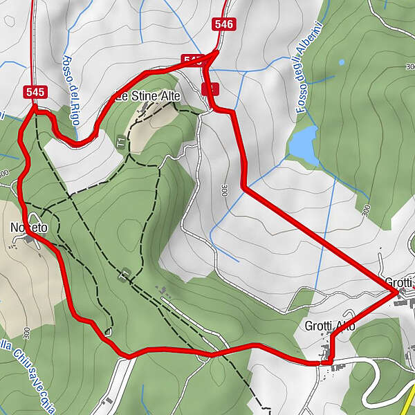
This walk provides extensive, panoramic views of the area known as ‘Crete Senesi’ and onwards towards Siena, including the woods and the hills around Stigliano. On the way it is possible to see “Le Stine” mediaeval castle, a very well conserved tower in a wonderful wooded area. Please note that much of the road from Stigliano to Grotti is along an unmade-up road.
- Difficulty
-
medium
- Rating
-
- Route
-
Grotti Alto0.1 kmGrotti Basso0.4 kmLe Stine Alte1.8 kmNoceto2.8 kmGrotti Alto4.0 km
- Description
-
This walk provides extensive, panoramic views of the area known as ‘Crete Senesi’ and onwards towards Siena, including the woods and the hills around Stigliano. On the way it is possible to see “Le Stine” mediaeval castle, a very well conserved tower in a wonderful wooded area. Please note that much of the road from Stigliano to Grotti is along an unmade-up road.
Start/car parking: From Stigliano drive down to the the main road and turn right. At the roundabout go straight over (signposted Grotti and Bagnaia). Turn right following the signpost for Bagnaia, past a golf course, and after half a mile turn left in the direction of Grotti. As you reach Grotti, 50 metres after the sign for the village, turn left downhill: after 200 metres there is grassy space for car parking on the right.
WALKFrom the car park go downhill and after 200 metres: Grotti Castle is on the right. In front of the Castle there is a typical gate with cypress on either side.
1. Opposite the gate turn left, ignoring the sign Strada Privata (Private Road). Follow this track straight downhill, and enjoy the view of Siena and Crete Senesi to the right. The track turns slightly first to the right and then to the left, and you will then be able to see the tower of Le Stine.
2. If you want get a closer look at the castle, take the path left, passing an olive orchard: bear right past the old castle gate with a chain, and then follow the path uphill to the castle. In mediaeval times Le Stine was a very important castle for Siena and was used as a farm from the time of the Renaissance until the last century. Now, although it is abandoned, it is still possible to see the tower and part of the system of walls.
Go back to the main track and turn left, once again providing a fantastic view of Crete Senesi. Continue for 200 metres, then turn left on the track that goes behind the castle, keeping the castle on your left. Continue for 300 metres, pass the olive groves and then follow the track as it continues to turn left and right, ignoring the paths on both sides. Continue on the main track until you get to an open field on your left: just after the field at a fork turn right downhill.
3. As a view of the straight track ahead of you opens out, turn immediately left up a small bank onto a narrow path; very soon take the right fork so as to avoid going steeply uphill at this stage. Continue on the small track going alongside the fields with the view of the valley, and then enter the woods. Follow the trail, start climbing and at the T junction go left and continue to go uphill until you reach the Podere Noceto (marked on the map). Stay on the left and continue on the main track, and soon you will reach the main road to Grotti. Turn left and following the road return to Grotti and your car.
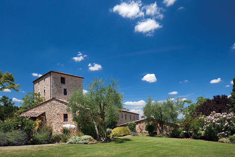
With its impressive stone tower standing sentinel over the valley, HPB Stigliano looks much as it did in the 13th century. The ancient buildings have, however, been restored to provide attractive holiday apartments. Please click here for further information about this beautiful Tuscan palazzo. - Highest point
- 372 m
- Height profile
-
 © outdooractive.com
-

-
AuthorThe tour HPB Stigliano: Grotti and Le Stine Castle is used by outdooractive.com provided.


-
Terre di Siena
27
-
Siena
14