

- Brief description
-
Varied and challenging loop over the Scheffauer summit.
- Difficulty
-
difficult
- Rating
-
- Starting point
-
Kaindlhütte, Scheffau (1,293 m)
- Route
-
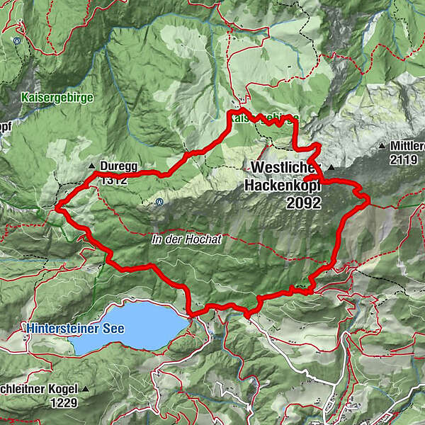
Seestüberl0.1 kmBichl0.2 kmStöfflhütte2.9 kmWalleralm3.2 kmJaga Bründl4.1 kmHochegg (1,470 m)4.7 kmScheffauerhöhle (1,900 m)8.0 kmScheffauer (2,111 m)8.3 kmSteiner Hochalm10.7 kmBärnstatt12.4 kmBärnstattkapelle Sankt Leonhard12.4 kmHinterstein12.8 kmBichl13.2 km
- Best season
-
JanFebMarAprMayJunJulAugSepOctNovDec
- Description
-
Ascent:
You start this tour at the Seestüberl at Hintersteiner See and hike in a northerly direction on the Steig 45a to the Walleralm. Here you have three places to stop for refreshments: the Kafma Alm, the Stöfflhütte and the Walleralm. Continue on the Steig 827 to the Hochegg and down to the romantic high plateau of the Steinbergalm to the cozy and family-run Kaindlhütte.
Shortly before the Kaindlhütte, turn south at a large boulder onto Widauersteig 814 and hike through shady forest and across alpine meadows to a kettle. Below the north walls, keep left until you reach the entrance to the Scheffauer. The Widauersteig is mostly secured with steel ropes. It runs west from a slab wall, crosses it on a band system and then leads up a gully on the left. Then it goes over switchbacks and partly loose gravel to the saddle at the summit ridge. From here it goes westward in about 10 minutes to the summit cross. From the summit of the Scheffauer there is a fantastic view to the Hintersteiner See, to the main ridge of the Alps as well as to the Inntal and to the Bavarian region.
Descent:
The descent is made back to the saddle on the summit ridge and then via the trail south down (one place rope-secured). Passing below the "Veitskirche" (stone formation) and over a gravel field, the "Hochofen", you reach the Steiner-Hochalm (1,257 m) on trail 814a in a southerly direction.
Here Peter and Maridi are waiting with cool drinks and harp music. For the last part of the descent, follow trail 821a to Bärnstatt and continue on the asphalt road back to Hintersteiner See.
Requirements: a good head for heights and surefootedness; HELMET for protection against rock fall
Recommended: climbing harness and via ferrata set
- Directions
-
The approach from the Kaindlhütte mountain hut takes around 1 hour to reach the entrance at the foot of the rock face, followed by a further 1.5 hours up to the summit of the Scheffauer.
You can reach the Kaindlhütte from the Hintersteiner See lake (car park at the Seestüberl restaurant or Pension Maier guesthouse) or from Kufstein via the Kaiserlift chairlift.
The Widauersteig trail is a very beautiful and not overly challenging route up to one of the westernmost summits of the Wilder Kaiser – the Scheffauer at 2,111 metres. The starting point is the cosy, family-run Kaindlhütte located on the romantic Steingbergalm Alpine pasture at 1,293 metres. The best way to reach the Kaindlhütte from the Wilder Kaiser region is around a 2-hour walk from the Hintersteiner See via the Walleralm Alpine pasture. The trail is largely secured with steel ropes and requires that walkers have absolute surefootedness together with a good head for heights. From the summit of the Scheffauer, there is a fantastic view towards the Hintersteiner See, over the main ridge of the Alps, into the Inntal valley and all the way to Bavaria.
Tip: make your descent via the southern side of the Wilder Kaiser, passing the Steiner-Hochalm mountain hut on the way to the Hintersteiner See or going via the Kaiser-Hochalm Alpine pasture to the Gasthof Jägerwirt inn.
Surefootedness and above all a good head for heights are essential!
Recommended: HELMET, as well as a climbing harness and via ferrata set for inexperienced climbers.
A securing rope should also be used for children. - Highest point
- 2,097 m
- Endpoint
-
Scheffauer (2,111 m)
- Height profile
-

- Equipment
-
Rucksack, hiking/mountaineering boots, hiking gear (breathable), change of clothes, sun protection (sunglasses, sun cream, headgear), waterproofs (hardshell), cold protection (gloves and hat), water bottle, food for eating on the way, hiking poles if desired, first aid kit, plastic bag for waste, hiking map/route description (gpx track)Via ferrata set, climbing harness and helmet;
- Arrival
-
Heading from Wörgl, Kufstein or St. Johann on the B178 road, take the exit to Scheffau and drive through the village as you continue in the direction of the Hintersteiner See. The hiking starting point and the pay & display car park are located next to the Seestüberl restaurant on the eastern bank of the lake.
- Public transportation
- Parking
-
Car park next to Seestüberl restaurant, Scheffau (889 m) – pay & display
- Author
-
The tour Crossing Scheffauer summit via Widauersteig trail is used by outdooractive.com provided.


General info
-
Kufsteinerland
2116
-
Scheffau am Wilden Kaiser
614


