Winter
Summer
Weather
Webcams
Accommodations
Tours
Search history
Search suggestions
No results found
Search
Tours
Home
Summer Österreich
Tyrol
Tours
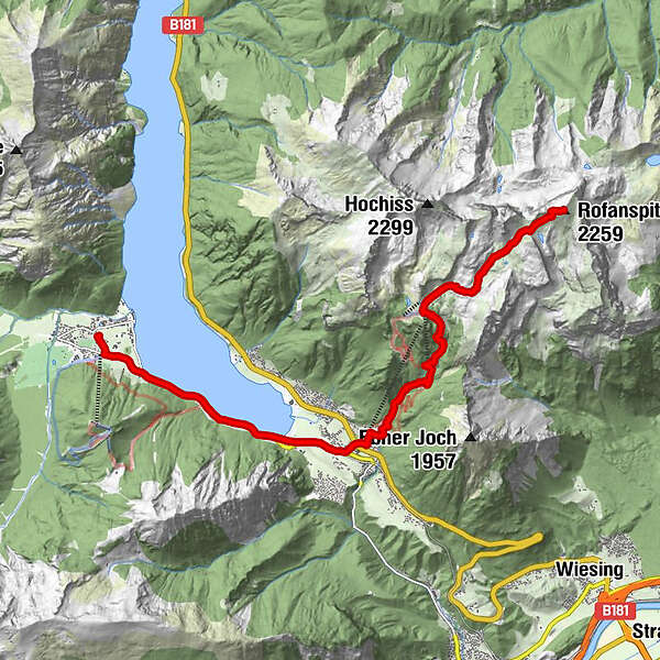
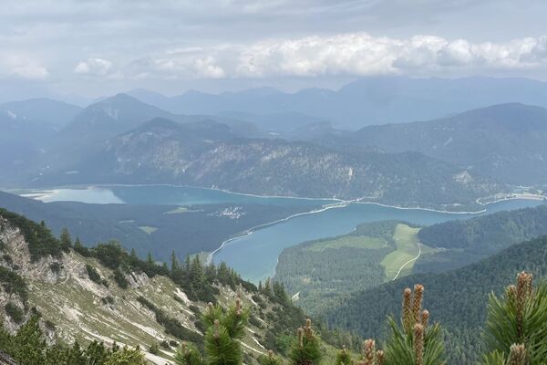
Rofanspitze
Regions
Weather
Webcams
Tours
Highlights
Bathing lakes
Accommodations
Offers
Sports provider
Events
Ski resorts
Cross-country skiing
Snow parks
Rofanspitze
Hiking
Bookmark
Map
show
hide
Print
Tour data
12.42
km
- 2,255
m
Distance
1,430
hm
126
hm
Ascent
04:10
h
Duration
Peter95
created am 14.06.2020
1,744
Views
Highest point
2,255 m
Write a review
Overall rating
5
0
%
4
0
%
3
0
%
2
0
%
1
0
%
Reviews
(0)
0 Comments
Write a review
Error
An error has occurred. Please try again.
Thank you for your review
Rating has been deleted
Report tour
GPS Downloads
GPX
GPS Exchange Format (XML)
KML
Google Earth, Google Maps
QR Download Codes for Mobile Phones
Rofanspitze
QR Codes - tour download for cell phones
GPX
KML
Other tours in the regions
Achensee
1390
Maurach - Eben am Achensee
453
Popular tours in the area
Hochiss and Dalfazer Kamm
difficult
Hiking
7.3
km |
650
hm |
03:30
h
Pertisau - Seeberg- & Seekarspitze
difficult
Hiking
6.48
km |
1323
hm |
02:26
h
Von Fall zum Demeljoch mit Blick auf den Sylvensteinspeichersee
medium
Hiking
20.38
km |
1307
hm |
06:30
h
Loassattel - Kuhmesser - Kellerjoch - Kellerjoch Kapelle - Hocheben...
medium
Hiking
8.7
km |
605
hm |
03:00
h
No entries found.
The search is currently not available.
Please refine your search.
Local search results
(<= 25km)
More results
(> 25km)
%count% Search results
%name%
%type%
%elevation%
%population%
%lpButton%