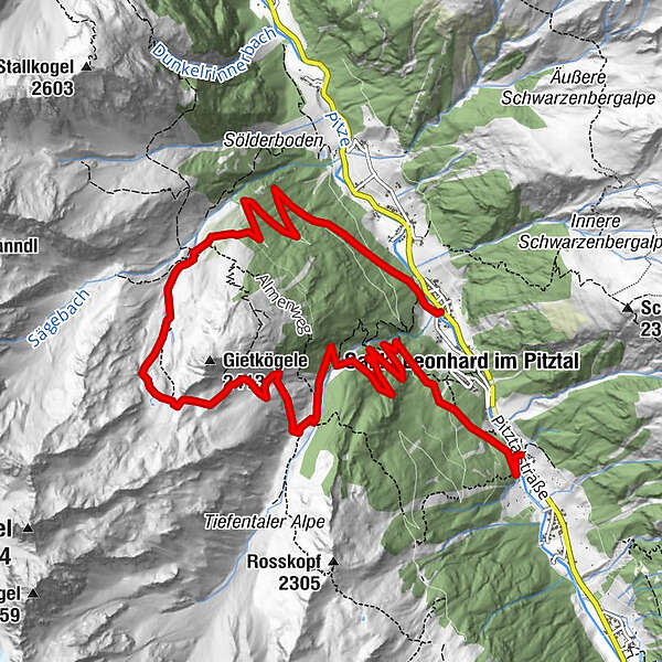
Eggenstall - Neubergalm 1889 through the Jägersteig to the Tiefental Alm 1880 m


- Brief description
-
You go northerrn on a farmer way with slow rise, trough a coolish forest til the alps ground of the Neubergalm. The Tiefental Alm is idillic by a border of a wood on a plateau with a runnel. Especially you have a good view to the Geigenkamm.
- Starting point
-
Eggenstall - Guesthouse Sonne - Liesele
- Route
-
Sankt Leonhard im Pitztal (1,366 m)EggenstallNeubergalm (1,889 m)3.3 kmTiefentalalm (1,900 m)6.9 kmPfitschebach Wasserfall9.7 kmSankt Leonhard im Pitztal (1,366 m)10.1 kmScheibe11.1 kmBiedere11.2 km
- Description
-
You start by Eggenstall (1352 m) in front of the guesthouse Sonne Liesele left over the bridge of the Pitzbach. Then you go on a easy route with curves approx. 2 hours to the Neubergalm. There you get a great view to the mountains of the Geigenkamm and a beautiful look to the valley. You go left upside the mountain pasture. then you steep along the runnel to the Sturzmahdsattel (westerly under the cliffy peak of the Gietkögels (2413 m). From there you see in front of you the steep rocked rocks from the Kaunergrat. On a good marked way you go precipices downward, over a hut and then across the runnel to the Tiefental Alm. Descend over a forestry road to Piösmes.
- Highest point
- 2,316 m
- Height profile
-

- Directions
-
From Plangroß 12 km to the Pitztaler state road into the valley to the little village Eggenstall
- Public transportation
-
You can use the free bus from Plangeroß til Guesthoue Sonne - Liesele


- Author
-
The tour Eggenstall - Neubergalm 1889 through the Jägersteig to the Tiefental Alm 1880 m is used by outdooractive.com provided.


-
Pitztal
1068
-
St. Leonhard im Pitztal
333


