- Brief description
-
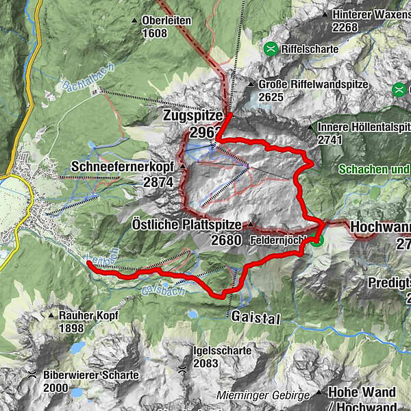
Beautiful mountain tour to the Zugspitze. With its highest point at almost 3,000 metres shared between Tirol and Bavaria, this makes it also the highest peak in Germany.
- Difficulty
-
difficult
- Rating
-
- Starting point
-
Valley station of Ehrwalder Almbahn
- Route
-
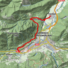
BrentAlm0.0 kmGanghofer Hütte (1,289 m)1.3 kmEhrwalder Alm2.6 kmPestkapelle4.0 kmHochfeldern-Alm4.4 kmGatterl (2,024 m)7.8 kmEhemalige Gatterlhütte8.5 kmKnorrhütte (2,052 m)10.1 kmGletscherbahn Bergstation13.8 kmZugspitze (2,962 m)13.8 km
- Best season
-
JanFebMarAprMayJunJulAugSepOctNovDec
- Description
-
The tour starts at the Ehrwalder Almbahn valley station (alternatively, take the cable car). From there turn right over the meadow path, past the BrentAlm. Continue past the Ganghofer Hütte (closed in summer), Ehrwalder Alm and the Tirolerhaus. Follow the forest path towards the Pestkapelle. Through a forest strip on the Max Klotz Steig, past the Hochfeldern Alm to the first pass, the trail descending slightly to the Feldernjöchl, past the junction to the Steinernes Hüttl, descending in a north-easterly direction first, then ascending steeply on a secured trail to the Gatterl. On the Plattsteig to the Knorrhütte, over scree and snowfields in a north-easterly direction to the Zugspitzplatt and further on the marked and secured trail to the Zugspitze summit (2,962m). Back to the valley by the Tiroler Zugspitzbahn. This tour is only recommended for experienced, surefooted hikers with a head for heights. Downhill with the Tiroler Zugspitzbahn.
- Directions
-
The meadow path to the Ehrwalder Alm begins above the valley station of the Ehrwalder Almbahn. Approx. 20 m after the sign, the path continues on the left meadow path to the stream, past the Ganghofer hut, follow the path to the Tirolerhaus, Berggasthof Ehrwalder Alm. After 150 m, the path branches off to the left to the "Wettersteinwand" house, past it, up to the forest and to the Pestkapelle (1617 m). Through a forest strip on the Max-Klotz-Steig, past the Hochfeldernalm (1732 m, managed) over pastures and through Latschen to the 1. Joch (Am Brand, 2120 m), the path gently falling to the Felddernjöchl (2041 m), junction to the "Stone Hut". Sloping in a northeasterly direction, then rising steeply on a secured path to the Gatterl (state border). On the Plattsteig - past the official huts of the Bavarian customs guard - to the Knorrhütte (2052 m managed). On a path marked with poles over scree and snow fields in a northeasterly direction on a marked and secured path to the Zugspitz summit (2962 m). From the Sonnalpin there is the possibility to reach the summit with the glacier lift. To the valley with the Tyrolean Zugspitzbahn. TIP: “Gatterl” hiking ticket
- Highest point
- 2,942 m
- Endpoint
-
Zugspitze
- Height profile
-

- Equipment
-
Weatherproof clothing, light snacks, water bottle, sturdy shoes
- Safety instructions
-
Stay on the marked trails. Surefootedness and a head for heights are required!
- Tips
-
"Gatterl" hiking ticket. The ticket includes the following services:
+ Ascent with the Ehrwalder Almbahn
+ Independent hike over the "Gatterl" to the valley station of the glacier lift (max. 6 hours)+ Ascent with the Bavarian Glacier Railway to the Zugspitze summit
+ Entry into the "Fascination Zugspitze" - adventure world ... with the best views!
+ Descent from the Zugspitze summit with the Tiroler Zugspitzbahn
+ Bus trip to the valley station of the Ehrwalder Almbahn
The tour can also be done from the Zugspitze down.
- Additional information
-
www.zugspitzarena.com
www.zugspitze.at
- Directions
-
Connections from Innsbruck only by car via A12 (1h 17min).
Connections from Munich only by car via A95 (1h 40min).
- Public transportation
-
Circuar buses within the Tiroler Zugspitz Arena during summer season.
- Parking
-
Free parking lot at Ehrwalder Almbahn
- Author
-
The tour Ehrwald - Gatterl - Zugspitze is used by outdooractive.com provided.


General info
-
Mieminger Plateau & Inntal
1686
-
Zugspitze
438