- Brief description
-
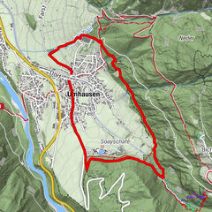
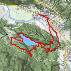
Längenfeld –> Brand –> Hängebrücke –> Burgstein –> Längenfeld
- Difficulty
-
medium
- Rating
-
- Starting point
-
Längenfeld
- Route
-
Längenfeld (1,179 m)0.1 kmOberlängenfeld0.6 kmMariahilfkapelle1.8 kmBrand1.8 kmOberlängenfeld6.7 km
- Best season
-
JanFebMarAprMayJunJulAugSepOctNovDec
- Description
-
The starting point of this hiking tour is the village center of Längenfeld at the height of Fischbach bridge. The first steps take walkers into the so-called Klamm (gorge) where some challenging altitude meters have to be made towards the hamlet of Brand. You take the forest road behind the church or you try the newly built rocky footpath. After about 40 walking minutes you have conquered the toughest part of this hike, you have finally reached Brand. Upthere you will be rewarded with a wonderful view of Längenfeld located below.
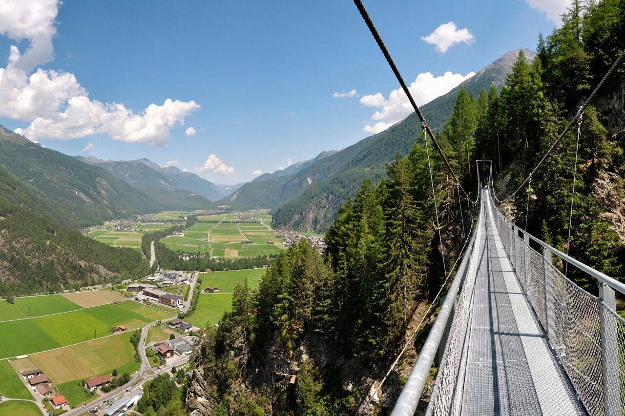
Magnificent vista points accompany you all the way to the mountain hamlet of Burgstein. Shortly before Burgstein you cross the 84 m long suspension bridge,connecting the two sun-kissed balconies of Brand and Burgstein, at about220 m above the valley floor. The view from the steel bridge is the undisputed highlight of this hike. Once in Burgstein, you take the old Burgstein Road (forest trail) down to Längenfeld. In Längenfeld you walk along the Albin Egger-Lienz theme trail and return to the starting point.
- Directions
-
The starting point of this hiking tour is the village center of Längenfeld at the height of Fischbach bridge. The first steps take walkers into the so-called Klamm (gorge) where some challenging altitude meters have to be made towards the hamlet of Brand. You take the forest road behind the church or you try the newly built rocky footpath. After about 40 walking minutes you have conquered the toughest part of this hike, you have finally reached Brand. Upthere you will be rewarded with a wonderful view of Längenfeld located below.
Magnificent vista points accompany you all the way to the mountain hamlet of Burgstein. Shortly before Burgstein you cross the 84 m long suspension bridge,connecting the two sun-kissed balconies of Brand and Burgstein, at about220 m above the valley floor. The view from the steel bridge is the undisputed highlight of this hike. Once in Burgstein, you take the old Burgstein Road (forest trail) down to Längenfeld. In Längenfeld you walk along the Albin Egger-Lienz theme trail and return to the starting point.
- Highest point
- 1,429 m
- Endpoint
-
Längenfeld
- Height profile
-

- Equipment
-
It is recommended to wear hiking equipment such as breathable and weather-adapted outdoor clothing.
- Safety instructions
-
Easy hike; suitable for beginners and walkers. Please pay attention to the current weather report.
- Tips
-
The hike with crossing the suspension bridge is as popular with guests as with the inhabitants of the Ötztal.
- Additional information
-
Längenfeld Basin under Water Until around 900 AD a lake covered most of the Längenfeld valley basin. From the hamlets of Brand and Burgstein you can perfectly make out the size of Längenfeld's valley basin!
Längenfeld Suspension Bridge:
The 82-meter long suspension bridge is one of Längenfeld’s latest attractions. The bridge is suspended high above the valley floor and offers superb panoramic views. Längenfeld’s popular panorama trail boasts a spectacular new feature in the so-called "Maurer Rinne" area! Between the hamlets of Brand and Burgstein hikers can now leave solid ground to walk 150 meters above ground on a steel suspension bridge with a span of 82 meters. The views of Längenfeld and its surroundings are absolutely magnificent!
More information about hiking can be found here
- Directions
-
The car drive to the Ötztal valley. Situated in Tirol, the Ötztal valley set off in southerly direction and is the
longest side valley in the Eastern Alps. The journey with the car leads you through the Inntal valley to the
entrance of the valley and further on through the valley. Among the toll motorways you can also use the country
roads. A route planner will show you the easiest and most convenient way: https://www.google.at/maps
- Public transportation
-
Travel safe and comfortable with the train to the Ötztal Bahnhof train station. Last stop and exit point is the
train station Ötztal Bahnhof. Afterwards you can travel smoothly and quick with the public transport or our local
taxi companies through the valley to your desired destination. Please find the current bus timetable here:
http://fahrplan.vvt.at
- Parking
-
The following parking facilities are available in Längenfeld:
- next to the old fire station (entrance to campsite) - free of charge
- Sports center - (football pitch and swimming pool) - free of charge
- Opposite the Ötztal Tourismus (small number of parking spaces) free of charge

- Author
-
The tour Water Walk Brand-Burgstein Längenfeld is used by outdooractive.com provided.


General info
-
Ötztal
1107
-
Längenfeld - Huben - Gries
354