
- Brief description
-
A classic ride with a challenging uphill stage and a few wonderful lakes which tempt you to stop for a breather and enjoy some cooling off along the route.
- Difficulty
-
difficult
- Rating
-
- Starting point
-
Kufstein Unterer Stadtplatz
- Route
-
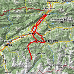
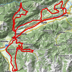
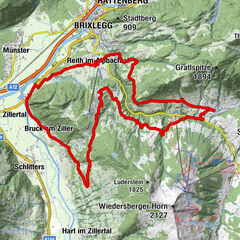
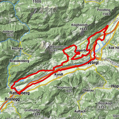
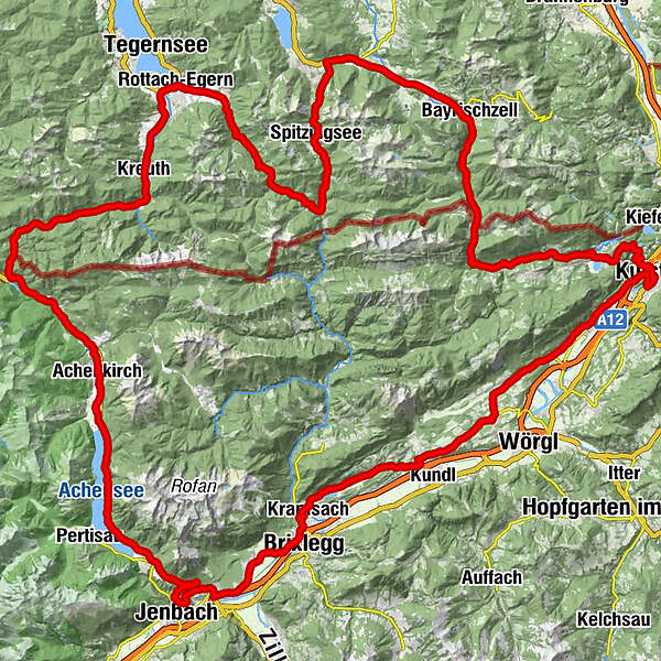
KufsteinZell1.7 kmMorsbach3.0 kmTiroler Fliegerstube5.0 kmSchaftenau (510 m)6.5 kmUnterlangkampfen (502 m)7.7 kmNiederbreitenbach (519 m)9.7 kmGasthof Dampflwirt9.8 kmNotburgakapelle10.0 kmBrand11.7 kmGasthof Kammerhof12.2 kmMariastein12.3 kmWallfahrtskirche Mariastein12.4 kmAngerberg15.4 kmFriedenskapelle16.0 kmDorf16.0 kmDorfer Kapelle16.6 kmGlatzham (644 m)17.8 kmGattererkapelle19.6 kmKleinsöll (592 m)19.7 kmGasthaus Krämerwirt19.7 kmStrass (552 m)20.9 kmKriegerdenkmal21.4 kmBreitenbach am Inn21.6 kmPfarrkirche Sankt Petrus21.7 kmAusserdorf22.3 kmAntoniuskapelle23.5 kmHaus (576 m)25.1 kmMoosenkapelle zum Heiligen Josef25.8 kmMosen (582 m)27.1 kmMoosen27.1 kmSeerose28.6 kmFischerstube28.6 kmGenuss Schmied'n Stadlerhof29.4 kmAchenrain30.7 kmWittberg (526 m)31.1 kmLändbühel31.6 kmKramsach31.6 kmAmerling31.8 kmHagau (517 m)32.7 kmBrixlegg32.8 kmPizzeria Buongiorno35.6 kmPfarrkirche Maria Himmelfahrt36.3 kmMünster (535 m)36.3 kmEntgasse36.8 kmHaus37.5 kmBradl38.7 kmBus-Stop39.7 kmWiesing39.8 kmErlach41.5 kmJenbach (563 m)43.0 kmFischl43.1 kmPanorama-Restaurant Kanzelkehre45.1 kmKanzelkehre45.4 kmEben am Achensee (970 m)47.2 kmMarienkirche48.9 kmMaurach48.9 kmMaximilian50.6 kmScholastika / Achenkirch58.8 kmHeiliger Johannes der Täufer62.4 kmAchenkirch (916 m)62.5 kmGasthof zur Marie67.5 kmHagenkapelle hll. Peter und Paul68.8 kmCantina Oramala68.9 kmAscherkapelle70.2 kmGlashütte75.7 kmBayerwald (852 m)78.5 kmKreuth (783 m)85.1 kmPoint87.2 kmScharling87.7 kmSchärfen88.3 kmPförn88.9 kmOberhof89.9 kmReitrain90.3 kmWeißach90.6 kmRottach-Egern91.7 kmKalkofen93.2 kmHaslau94.2 kmEllmösl94.2 kmAlmhof95.8 kmEnterrottach95.9 kmRottachfall96.8 kmWildbachhütte98.6 kmSpitzingsee111.1 kmSt. Bernhard von Menthone111.1 kmSpitzingsattel112.4 kmFischeralm118.2 kmGasthof Mairhofer118.3 kmWölflhof118.3 kmAurach118.4 kmHagnberg119.3 kmHammer119.4 kmHeißenbauer120.8 kmRied122.0 kmKlarermühl122.7 kmNiederhofen123.0 kmOsterhofen123.3 kmKaminstub'n124.8 kmBayrischzell126.2 kmBeim schweren Gatter129.6 kmHörhagbrücke135.2 kmPfarrkirche Maria Hilf137.3 kmLandl137.3 kmKrämerwirt137.4 kmAscherdorf138.9 kmSchmiedtal140.3 kmVorderthiersee144.5 kmLechen145.4 kmHippbichl150.4 kmKufstein151.9 kmKufstein152.1 km
- Best season
-
JanFebMarAprMayJunJulAugSepOctNovDec
- Description
-
From Kufstein head towards Mariastein (pilgrimage town). Then, cycle via Breitenbach to Lake Reintaler and to Kramsach, continuing through gorgeous scenery past Münster and head to Wiesing. The ascent to Lake Achensee is with heavy traffic but along the wonderful lake you drive on the cycle path. Getting to Achenpass it is then a few kilometres slightly downhill to Lake Tegernsee. In Rottach-Egern proceed right into the beautiful and calm Valepp. At Lake Spitzingsee reach the antivline Spitzingsattel and roll quickly downhill towards Bayrischzell. Cross the tranquil Ursprungpass continuing across the border to Thiersee. After a short stop at the Passion Play Theatre with views to the lake, climb the last meter uphill to Marblinger Höhe and enjoy the final kilometres downhill to Kufstein.
- Highest point
- 1,126 m
- Endpoint
-
Kufstein Unterer Stadtplatz
- Height profile
-

- Equipment
-
Cycling helmet, comfortable cycling clothing, change of clothes, wind protection, cycling gloves, possibly rucksack with water bottle and food, first aid equipment, possibly service/repair kit, cycling map, tour description and information material (GPX track), ID card, insurance card, cash
- Directions
-
From the Inntal motorway A12, take the Kufstein Nord exit.
- Public transportation
-
Kufstein main railway station is only a few minutes' walk from the starting point.
- Parking
-
Kufstein centre
- Author
-
The tour 09 - Achensee-Circuit is used by outdooractive.com provided.


-
Alpbachtal
43
-
Brandenberg
19