
- Brief description
-
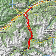
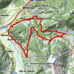
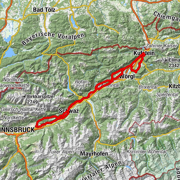
The year 2018 in Kufstein was dedicated entirely to roadbiking. If you want to experience the tracks of the UCI Road World Championship just like the pros, this section through the Inn Valley offers you the best opportunity to do so.
- Difficulty
-
medium
- Rating
-
- Starting point
-
Kufstein city centre
- Route
-
Kufstein0.0 kmStadtpfarrkirche Heiliger Vitus0.0 kmMitterndorf0.5 kmEndach1.8 kmRussland3.7 kmRied4.2 kmAm Bach4.6 kmMoosham5.1 kmSchwoich5.5 kmPfarrkirche Heiliger Ägidius5.7 kmKirchenwirt5.7 kmNeuwirt5.7 kmBierol Taproom & Restaurant6.6 kmSonnendorf6.6 kmHabring8.5 kmOsterndorf9.6 kmLourdeskapelle9.6 kmBad Häring10.1 kmPfarrkirche Heiliger Johannes der Täufer10.1 kmBichlwang (518 m)12.2 kmOberlangkampfen (494 m)13.5 kmGasthof Huberwirt15.1 kmGasthof Dampflwirt15.8 kmNiederbreitenbach (519 m)15.8 kmNotburgakapelle16.0 kmBrand17.8 kmGasthof Kammerhof18.2 kmWallfahrtskirche Mariastein18.3 kmMariastein18.3 kmAngerberg21.4 kmFriedenskapelle22.0 kmDorf22.1 kmDorfer Kapelle22.6 kmGlatzham (644 m)23.8 kmGasthaus Krämerwirt25.8 kmGattererkapelle25.8 kmKleinsöll (592 m)25.8 kmStrass (552 m)26.9 kmKriegerdenkmal27.4 kmBreitenbach am Inn27.6 kmPfarrkirche Sankt Petrus27.7 kmAusserdorf28.4 kmAntoniuskapelle29.5 kmHaus (576 m)31.1 kmMoosenkapelle zum Heiligen Josef31.8 kmMosen (582 m)33.1 kmMoosen33.1 kmSeerose34.6 kmFischerstube34.7 kmGenuss Schmied'n Stadlerhof35.4 kmAchenrain36.7 kmWittberg (526 m)37.1 kmLändbühel37.6 kmKramsach37.7 kmAmerling37.8 kmHagau (517 m)38.7 kmBrixlegg38.8 kmPizzeria Buongiorno41.6 kmPfarrkirche Maria Himmelfahrt42.3 kmMünster (535 m)42.4 kmEntgasse42.8 kmHaus43.7 kmBradl44.8 kmBus-Stop45.9 kmWiesing46.1 kmDorfwirt46.3 kmPfarrkirche Heiliger Wolfgang und Leonhard49.5 kmJenbach (563 m)49.6 kmHupfaufkapelle50.5 kmTratzberg52.3 kmFriedhofskapelle55.0 kmGasthof Marschall55.2 kmStans55.2 kmSchwaz57.8 kmSchwaz58.0 kmVomp60.1 kmGasthaus Pelikan60.2 kmVomperbach62.3 kmTerfens65.0 kmSchlögelsbach67.0 kmMairbach67.9 kmBrantach68.6 kmKranzach69.6 kmSt. Michael70.7 kmGnadenwald (879 m)71.3 kmSpeckbacherkapelle71.5 kmAußerwald71.6 kmSt. Martin72.1 kmWalderkapelle74.5 kmNepomukkapelle75.3 kmSchmankerlstock75.8 kmPfarrkirche Eichat76.0 kmLa Taverna76.8 kmHall in Tirol (574 m)77.9 kmKaiser Franz Josef-Gedächtniskapelle77.9 kmFranziskuskirche78.9 kmMils (605 m)79.4 kmLourdeskapelle80.3 kmBaumkirchen (593 m)82.9 kmFritzens-Wattens84.8 kmFritzens (591 m)84.8 kmWattens (564 m)85.0 kmNeuterfens89.1 kmTerfens89.6 kmPill (556 m)92.4 kmSpielplatz Altmahd92.8 kmAltmahd92.9 kmSchwaz95.8 kmSpitalskirche Hl. Geist und Johannes der Täufer95.9 kmStans98.9 kmGasthof Marschall99.0 kmFriedhofskapelle99.2 kmTratzberg102.3 kmHupfaufkapelle104.0 kmJenbach (563 m)105.0 kmPfarrkirche Heiliger Wolfgang und Leonhard105.0 kmAlevitischer Kulturverein Jenbach105.4 kmDorfwirt107.9 kmWiesing107.9 kmBus-Stop108.2 kmBradl109.1 kmHaus110.2 kmEntgasse111.1 kmMünster (535 m)111.5 kmPfarrkirche Maria Himmelfahrt111.8 kmPizzeria Buongiorno112.1 kmBrixlegg115.2 kmHagau (517 m)115.3 kmAmerling116.3 kmLändbühel116.4 kmKramsach116.7 kmKuglgasse116.8 kmUnterkramsach117.2 kmBadl117.7 kmRattenberg117.9 kmRadfeld119.2 kmKapelle St. Leonhard in der Au120.0 kmBreitenbach am Inn126.2 kmPfarrkirche Sankt Petrus126.3 kmKriegerdenkmal126.4 kmOberdorf127.1 kmSchönau (593 m)130.7 kmThaler-Kapelle130.8 kmEmbach133.6 kmGatterer Kapelle134.4 kmMariastein136.1 kmBrand136.6 kmNotburgakapelle138.2 kmNiederbreitenbach (519 m)138.4 kmGasthof Dampflwirt138.5 kmUnterlangkampfen (502 m)140.5 kmSchaftenau (510 m)141.7 kmTiroler Fliegerstube143.1 kmMorsbach145.2 kmZell146.7 kmKufstein148.4 km
- Best season
-
JanFebMarAprMayJunJulAugSepOctNovDec
- Description
-
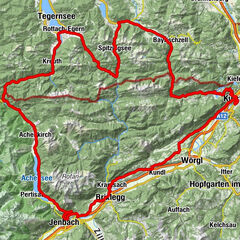
Start is like with the professionals at the upper town square in Kufstein. But we leave the neutralized lap out and start directly south. Over the sunny plateau Schwoich and Bad Häring we quickly descend towards Kirchbichl. From there, the route leads through the picturesque pilgrimage site of Mariastein and on over the quiet roads to Angerberg, always towards the Reintaler lakes. Until Kramsach we are on the original route. Since we want to avoid the busy main road between Brixlegg and Schwaz (unfortunately, our trip is not closed by a police escort and track marshal), we take the much more pleasant roads via Münster, Wiesing and Jennbach to Vomperbach. There one comes again on the original course up to Gnadenwald. Here the ascent waits relentlessly for the calves. The descent to Hall offers relaxation. Due to the traffic, it is better not to venture into Innsbruck, especially as many parts of the route are not really passable due to the pedestrian zone. In Hall, the turning point is back. Via Fritzens, Pill and then on the same route as on the outward journey, one gets to Rattenberg, always in reasonably flat terrain. There, one once again takes a last ascent from Breitenbach am Inn to Schönau in order to enjoy the idyllic roads in the direction of Langkampfen and back to Kufstein.
- Highest point
- 896 m
- Endpoint
-
Kufstein city centre
- Height profile
-

- Equipment
-
Cycling helmet, comfortable cycling clothing, change of clothes, wind protection, cycling gloves, possibly rucksack with water bottle and food, first aid equipment, possibly service/repair kit, cycling map, tour description and information material (GPX track), ID card, insurance card, cash
- Directions
-
From the Inntal motorway A12, take the Kufstein Nord exit.
- Public transportation
-
Kufstein main railway station is only a few minutes' walk from the starting point.
- Parking
-
Kufstein centre
- Author
-
The tour 01 - In the footsteps of the UCI World Cycling Championships is used by outdooractive.com provided.


-
Alpbachtal
43
-
Münster
17