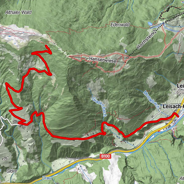
Hochsteinhütte

Logo Hochsteinhütte
Logo Hochsteinhütte
Tour data
15.3km
673 - 2,057m
Distance
1,384hm
Ascent
04:00h
 
Duration
Brief description

Wunderschöne Aussicht belohnt für die Strapazen!

Difficulty
medium
Rating
Technique
Fitness
Landscape
Experience
Starting point

Lienz (672m)

Route
Leisach-Gries
0.1 km
Burgfrieden
1.6 km
Bannberg
6.2 km


Highest point
2,057 m
Endpoint

Hochsteinhütte (2023 m)


Rest/Retreat

Hochsteinhütte (2023 m)

Ticket material

Tourismusbüro Lienz


2,5
Overall rating

5

0

%

4

50

%

3

0

%

2

0

%

1

50

%

GPS Downloads
  • GPX GPS Exchange Format (XML)
  • KML Google Earth, Google Maps
QR Download Codes for Mobile Phones

Surfaces

Asphalt
Gravel
Forest
Mountain paths
Single trails
Trial
Traffic

Popular tours in the area

Pustertaler Höhenstraße

medium Mountainbike
55.83km | 1282hm | 04:30h

KM4 - Strajach-Mussen

medium Mountainbike
24.75km | 788hm | 03:00h

Porzehütte/Tilliacher Joch am Karnischen Kamm

medium Mountainbike
8.99km | 681hm | 02:30h

L1 - Wolayersee

difficult Mountainbike
16.5km | 1228hm | 04:09h