Breitlehn- und Kapuzinerjöchl (vom Ötztal ins Pitztal) - Längenfeld/Huben


- Brief description
-
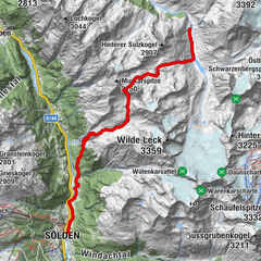
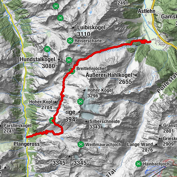
HUBEN -> Breitlehnalm -> Breitlehnjoch -> Kapuzinerjoch -> Gahwinden -> Rüsselsheimer Hütte -> PARKPLATZ WEISSWALD
- Difficulty
-
difficult
- Rating
-
- Starting point
-
Huben - Ötztal
- Route
-
Breitlehnalm (1,874 m)2.6 kmRüsselsheimer Hütte12.5 kmPlangeross15.2 km
- Best season
-
JanFebMarAprMayJunJulAugSepOctNovDec
- Description
-
Who chooses the ascent on foot, goes from the small group of houses "Mühl" in Huben on a trail directly to Breitlehnalm. From the pasture, a path leads into the entrance of the grazing high valley and ascends at a steady slope until you reach the bottom filled with boulders and rocks. From the Breitlehnjoch you can look for the first time at the characteristic Kaunergrat (Watzespitze, Verweilspitze ...). An overall picture that always amazes you. The climb to the Kapuzinerjöchl takes all the attention. After crossing a scree slope, small bends through rocky terrain lead very steeply to the yoke. By the Rötenkar first down and on the opposite hand is up to the viewpoint Gahwinden. The Rüsselsheimer hut (about 45 minutes away) can already be seen. During the descent into the Pitztal to the parking lot between the white forest and Plangeross, one is accompanied by the sight of the idiosyncratic rock forms of the Kaunergratberge.
- Directions
-
The ascent to Breitlehnalm via a hiking trail which leads through dense forest. From the pasture, it goes through meadows at the beginning. The path is getting steeper and rougher. A rubble slope leads up to Breitlehnjoch. The climb to the Kapuzinerjöchl is cable insured and requires all the attention. Through the Rötenkar you descend to take on the opposite slope again the rise to the lookout point Gahwinden. The Rüsselsheim hut is already visible. The descent into the Pitztal runs on a well walkable path.
- Highest point
- 2,695 m
- Endpoint
-
Weißwald - Pitztal
- Height profile
-

- Equipment
-
Appropriate equipment such as breathable suitable outdoor clothes for the weather, ankle-high walking boots,
wind-, rain- & sun protection, hat, possibly gloves, is for all hikes and tours necessary. Please bring a first-aid
box, a mobile phone, a walking map and if there is no hut on the way a snack and enough to drink.
- Safety instructions
-
For experienced mountaineers that are free from vertigo & surefooted, Very good physical condition, mountain
experience & mountain equipment (see notice equipment) necessary, such as alpine security material, good
weather conditions recommended. Please pay attention to the current weather report:
- Tips
-
The hut taxi runs once a week during the summer season. A reservation is required.
Ötztal Tourismus - Information Längenfeld+43 (0)57200 300
- Additional information
-
In 2001, the former New Chemnitz Hut was renamed Rüsselsheimer Hütte. The important base in the middle part of the Geigenkamm Höhenweg is not only epic because of its location and its wildlife, but also in culinary terms. For example, you can enjoy delicacies from Capricorn here.
Due to the long walking time, the driveway to Breitlehnalm with the hut taxis makes sense. If one walks from Huben on foot, an overnight stay on the Rüsselsheimer hut is to be recommended.
The way back to the starting point can be done by bus via Imst. - Directions
-
The car drive to the Ötztal valley. Situated in Tirol, the Ötztal valley set off in southerly direction and is the
longest side valley in the Eastern Alps. The journey with the car leads you through the Inntal valley to the
entrance of the valley and further on through the valley. Among the toll motorways you can also use the country
roads. A route planner will show you the easiest and most convenient way: https://www.google.at/maps
- Public transportation
-
Travel safe and comfortable with the train to the Ötztal Bahnhof train station. Last stop and exit point is the
train station Ötztal Bahnhof. Afterwards you can travel smoothly and quick with the public transport or our local
taxi companies through the valley to your desired destination. Please find the current bus timetable here:
http://fahrplan.vvt.at
- Parking
-
The following parking spaces are available:
Huben - fun park - free

- Author
-
The tour Breitlehn- und Kapuzinerjöchl (vom Ötztal ins Pitztal) - Längenfeld/Huben is used by outdooractive.com provided.