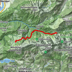
Söll - Achleitberg - Hintersteiner See

Logo Söll - Achleitberg - Hintersteiner See
long-distance walking trail
Logo Söll - Achleitberg - Hintersteiner See
Tour data
9.14km
602 - 1,009m
Distance
421hm
Ascent
02:00h
 
Duration
Rating
Technique
Fitness
Landscape
Experience
Starting point

Dorfzentrum Söll

Route
Söll
0.0 km
Dorfbichl
0.5 km
Gasthof Oberstegen
2.2 km
Achleitberg
5.3 km
Schupfen
6.8 km
Hochegg
7.4 km
Greidern
7.8 km
Marienkapelle Gut Alte Mühle
8.8 km
Bichl
8.9 km


Highest point
1,009 m

Rest/Retreat

Franzlhof in Söll, Gasthof Achleiten, Seestüberl am Hintersteiner See


Overall rating

5

0

%

4

0

%

3

0

%

2

0

%

1

0

%

Error
An error has occurred. Please try again.
Thank you for your review

Rating has been deleted

GPS Downloads
  • GPX GPS Exchange Format (XML)
  • KML Google Earth, Google Maps
QR Download Codes for Mobile Phones
Other tours in the regions

Popular tours in the area

Güttlersteig to Sonneck Wilder Kaiser

difficult long-distance walking trail
28.27km | 2347hm | 12:30h

Kaiserkrone - alternative route crossing through the Ellmauer Tor (...

difficult long-distance walking trail
6.5km | 537hm | 05:00h

Kaiserkrone - stage 4

medium long-distance walking trail
16.22km | 555hm | 06:30h

Kaiserkrone - stage 3

medium long-distance walking trail
9.46km | 767hm | 05:00h