Kaiserkrone - alternative route bypassing Klamml

long-distance walking trail

- Brief description
-
Gaudeamushütte – Gamswegl – path 825 – Gruttenhütte
- Difficulty
-
medium
- Rating
-
- Starting point
-
Gaudeamushütte, Going (1,263 m)
- Route
-
Gruttenhütte3.3 km
- Best season
-
JanFebMarAprMayJunJulAugSepOctNovDec
- Description
-
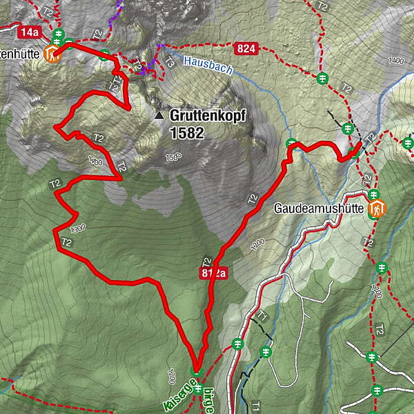
You can bypass the Klamml using the following route (which does not feature any exposed sections):
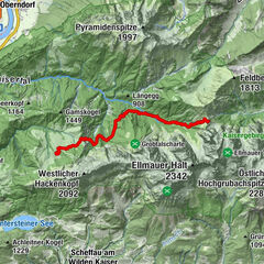
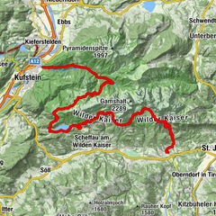
You will come to path 824 from the Bergsteigergrab, turning onto path 812a above the Gaudeamushütte mountain hut as you head south towards the Wochenbrunner Alm via Gamswegl. Follow this trail through the forest, then through a field of scree. Back in the forest, you then head to the intersection with path 825. You should then follow this path north to the Gruttenhütte mountain hut. This path largely leads through a thin forest up to the tree line. Making your way across rocky terrain, you will first come to the Gruttenkopf peak and then the Gruttenhütte (1,620 m), the highest mountain hut in the Wilder Kaiser region. - Directions
-
You can bypass the Klamml using the following route (which does not feature any exposed sections):
You will come to path 824 from the Bergsteigergrab, turning onto path 812a above the Gaudeamushütte mountain hut as you head south towards the Wochenbrunner Alm via Gamswegl. Follow this trail through the forest, then through a field of scree. Back in the forest, you then head to the intersection with path 825. You should then follow this path north to the Gruttenhütte mountain hut. This path largely leads through a thin forest up to the tree line. Making your way across rocky terrain, you will first come to the Gruttenkopf peak and then the Gruttenhütte (1,620 m), the highest mountain hut in the Wilder Kaiser region. - Highest point
- 1,619 m
- Endpoint
-
Gruttenhütte, Ellmau (1,620 m)
- Height profile
-

- Equipment
-
Rucksack, sturdy hiking/mountaineering boots with anti-slip treaded soles, weather-appropriate hiking gear (breathable), a change of clothes, sun protection (sunglasses, sun cream, lip protection, headgear), waterproofs (rain jacket/poncho, pocket umbrella, rucksack protector), cold protection (hat, gloves), sufficient food and drink, hiking poles (height adjustable) if required, first aid kit incl. rescue blanket and bivouac sack, mobile phone with fully charged battery, headlamp, plastic bag for waste, hiking map, route description and information materials (GPX track), ID, insurance card, cash
Additions for overnight stay at mountain hut:
Mountain hut sleeping bag, indoor shoes, toiletries and towel, personal medication, headlamp, Alpine Club ID Card, cash, charger for mobile phone
The hiking routes between the huts are often rather long, we recommend taking plenty of food and drink and booking your overnight stays well in advance. - Directions
-
You can bypass the Klamml using the following route (which does not feature any exposed sections):
You will come to path 824 from the Bergsteigergrab, turning onto path 812a above the Gaudeamushütte mountain hut as you head south towards the Wochenbrunner Alm via Gamswegl. Follow this trail through the forest, then through a field of scree. Back in the forest, you then head to the intersection with path 825. You should then follow this path north to the Gruttenhütte mountain hut. This path largely leads through a thin forest up to the tree line. Making your way across rocky terrain, you will first come to the Gruttenkopf peak and then the Gruttenhütte (1,620 m), the highest mountain hut in the Wilder Kaiser region.
- Author
-
The tour Kaiserkrone - alternative route bypassing Klamml is used by outdooractive.com provided.
GPS Downloads


General info
Refreshment stop
Flora
Fauna
A lot of view
Other tours in the regions
-
Wilder Kaiser
1945
-
Ellmau
638