


- Brief description
-
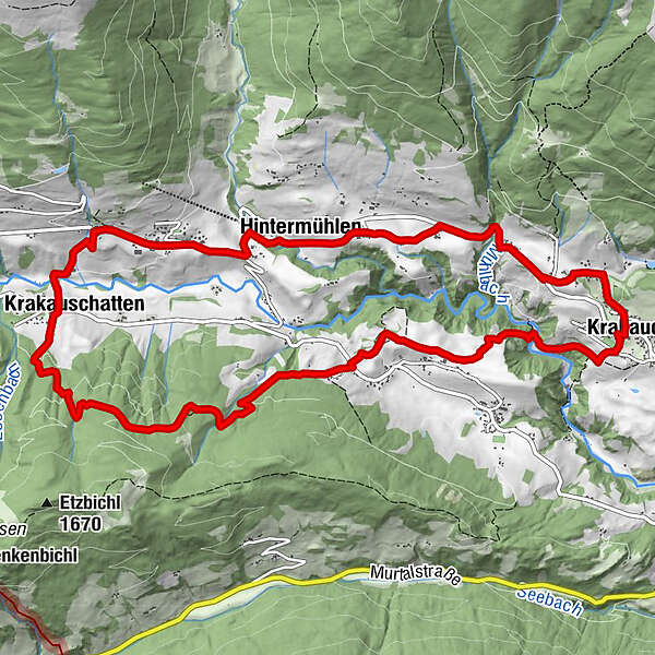
The circular trail leads through the scenic, beautiful Krakow Valley and offers one or the other panoramic view!
- Difficulty
-
medium
- Rating
-
- Starting point
-
Krakaudorf, church
- Route
-
Pfarrkirche hl. OswaldKrakaudorf0.0 kmOberetrach2.0 kmKapelle2.5 kmKrakauschatten7.1 kmPfarrkirche hl. Ulrich8.0 kmRestaurant Stigenwirth8.1 kmKrakauebene8.6 kmWegkapelle9.0 kmHintermühlen9.9 kmScharnigl12.8 kmKrakaudorf13.4 kmPfarrkirche hl. Oswald13.5 km
- Best season
-
JanFebMarAprMayJunJulAugSepOctNovDec
- Directions
-
Start at the parish church Krakaudorf. Worth seeing in the church is the wooden coffered ceiling. From here on trail no. 9 to Oberetrach, along the nature trail. Continue on trail no. 9 towards Holzerhütte, branch off on trail no. 9a to the main road. Cross this and take trail no. 8 to Krakauebene. At the church (you can also visit it) turn right along the road to the ski lift. From here, turn right onto the Roseggerweg trail to Krakaudorf.
- Highest point
- 1,430 m
- Endpoint
-
Krakaudorf
- Height profile
-

- Equipment
-
Good footwear
Sun protection
Sufficient food - Additional information
-
The ideal time for this tour is from May to October.
- Directions
-
East: From Vienna on the A 2 and S 6 to Leoben and St. Michael i. d. O., continue on the S 36 to Judenburg and on the B 96 to Murau. From Murau via Ranten to Krakau.
West, North: From Bregenz/Innsbruck via the A 12, A 93 and A 8 to Salzburg. From Salzburg on the A 10 to St. Michael im Lungau. From here, take the B 96 to Tamsweg and continue in the direction of Murau via Sauerfeld to Krakau.
South: From Klagenfurt on the B 83 to Scheifling. Then on the B 96 to Murau and further into the Krakau.
- Public transportation
-
With the BusBahmBim app from Verbundlinie, timetable information has never been easier: all bus, train and streetcar connections in Austria can be queried by entering locations and/or addresses, stops or important points. The app is available as a free app for smartphones (Android, iOS) - on Google Play and in the App Store.
- Parking
-
Parking is available in Krakaudorf at the church.

- Author
-
The tour KrakauValley - circular hiking trail is used by outdooractive.com provided.


