
- Brief description
-
This is a moderately difficult hike, but has a leisurely course.
- Difficulty
-
medium
- Rating
-
- Starting point
-
Feistritz Castle
- Route
-
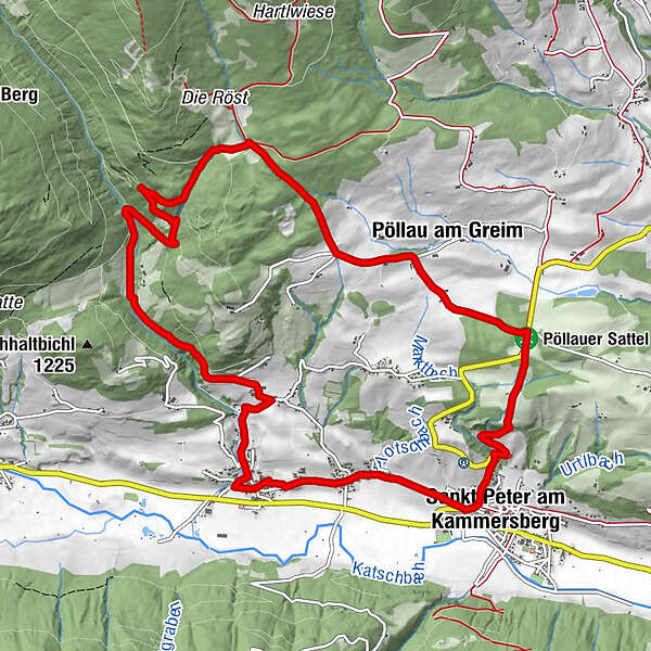
Feistritz am Kammersberg0.2 kmSchmieding1.3 kmPöllau am Greim7.6 kmPöllauer Sattel (1,092 m)8.9 kmGasthof Trattner9.8 kmSankt Peter am Kammersberg10.9 kmMitterdorf12.0 kmFeistritz am Kammersberg12.6 km
- Best season
-
JanFebMarAprMayJunJulAugSepOctNovDec
- Description
-
A wonderful hike away from the main road. Cozy benches along the way invite you to linger, so you can really enjoy and explore the picturesque landscape around St. Peter am Kammersberg and Feistritz.
- Directions
-
From the starting point S6 you first go towards the center of Feistritz and hike to the “Kötzlmühle”. There you have the opportunity to refresh yourself at the oak fountain. Continue along “Schmiedingweg” to the chapel and turn left into Feistritzgraben. Hike towards "Röst" - stage 4. Then you walk downhill along a forest path into the Vordere Pöllau, past the "Penkerer" farm until you come to the "Schwarze Sau" intersection. Walk a short distance down the road to the right and turn left onto the forest path to the "Luagtrattner" farm, from there the hike continues to the Trattner inn - stage 1. Then the walk goes down to St. Peter to the starting point S1 - Vicarage. From here you hike towards Mitterdorf and then back to the starting point via Feistritz.
- Highest point
- 1,349 m
- Endpoint
-
Feistritz Castle
- Height profile
-

- Equipment
-
Good shoes
Sun protection
Possibly food - Additional information
-
The ideal time for this tour is from May to October.
- Directions
-
Coming from Judenburg via Unzmarkt to Scheifling. Turn right here and drive towards Murau. In Katsch in der Mur, keep right again and drive via St. Peter am Kammersberg to Feistritz.
Coming from Tamsweg, drive via Ranten (or Stadl an der Mur) to Murau. Keep left here and drive via Schöder to Feistritz.
- Public transportation
-
With the BusBahnBim app from the interconnected line, timetable information is easier than ever before: all bus, train and tram connections in Austria can be queried by entering locations and/or addresses, stops or important points. The app is available as a free app for smartphones (Android, iOS) - on Google Play and in the App Store.
- Parking
-
Public parking spaces are available in Feistritz.


- Author
-
The tour Feistritzgraben round is used by outdooractive.com provided.