
- Brief description
-
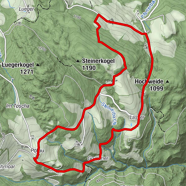
This 7.1 kilometer long hike leads through Pöllau near St. Marein.
- Difficulty
-
easy
- Rating
-
- Starting point
-
Pöllauerhof
- Route
-
Pöllau0.0 kmPfarrkirche hl. Leonhard0.0 kmBuschenschank Zeischgl3.9 kmPfarrkirche hl. Leonhard7.1 kmPöllau7.1 km
- Best season
-
JanFebMarAprMayJunJulAugSepOctNovDec
- Description
-
This hike offers a fantastic view of the Zirbitzkogel from the 7-church view, a giant swing and wonderful insights into the flora of the Murau region.
- Directions
-
The tour takes us from Pöllauerhof under the church left towards Grundnerhof. From there it goes via the Haslwirt to the Buschenschank Zeischgl. It’s definitely worth a stop! Across the meadow you can reach the giant swing and the “7-Kirchen-Blick” observation tower (freely accessible at any time). Through a forest you reach the Steinerhof (holiday at the riding farm). From there you take the road back to the starting point.
- Highest point
- 1,147 m
- Endpoint
-
Pöllauerhof
- Height profile
-

- Equipment
-
Good shoes
Sun protection
Sufficient food - Additional information
-
The ideal time for this tour is from April to October.
- Directions
-
By car from Germany
From Munich via the A8 towards Salzburg. From Salzburg on the A10 Tauernautobahn to St. Michael im Lungau. On the B 96 to Tamsweg, then on the B 95 to Predlitz. The B 97 leads via Stadl/Mur to Murau. There at the roundabout towards St. Lambrecht to Murauer train station and further towards St. Lambrecht. Via Laßnitz near Murau you reach St. Lambrecht, which is already located in the Zirbitzkogel-Grebenzen Nature Park. From there continue towards Mariahof and Neumarkt. In Mariahof turn right towards Neumarkt. Continue to St. Marein, turn right immediately after the pedestrian traffic lights. Continue to Mühldorf and then to Pöllau.Arrival from Eastern Austria/Hungary
At the motorway junction in St. Michael near Leoben, take the S 36 towards Klagenfurt. Past Knittelfeld and Judenburg to Scheifling. In Scheifling continue towards Klagenfurt to Neumarkt, via Unzmarkt and Perchau am Sattel you reach Neumarkt. Drive through Neumarkt, then turn right at the pedestrian traffic lights in St. Marein. Continue to Mühldorf and then to Pöllau.Arrival from southern Austria/Italy
Via Klagenfurt on the S 37 past St. Veit/Glan, Treibach and Friesach. In Friesach continue towards Vienna, via Dürnstein and Wildbad to St. Marein. Turn left just before the pedestrian traffic lights. Continue to Mühldorf and then to Pöllau. - Public transportation
-
With the BusBahnBim app from the interconnected line, timetable information is easier than ever before: all bus, train and tram connections in Austria can be queried by entering locations and/or addresses, stops or important points. The app is available as a free app for smartphones (Android, iOS) - on Google Play and in the App Store.
- Parking
-
Public parking spaces are available directly at the Pöllauerhof.

- Author
-
The tour Pöllau circular hiking trail is used by outdooractive.com provided.