- Brief description
-
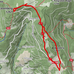
An approx. 10 kilometre hike from Hartberg to Eggendorf, Unterlungitz to the Lafnitztal valley to the Maierhofermühle mill with the option of returning to Hartberg by bus. (Please note the timetable and opening hours of the restaurants along the route. They are closed on Mondays and Tuesdays).
- Difficulty
-
easy
- Rating
-
- Starting point
-
Hartberg, bus station
- Route
-
HartbergGasthaus Eggendorfwirt3.4 kmEggendorf3.4 kmUnterlungitz5.1 kmGasthaus Maierhofer-Mühle8.1 km
- Best season
-
JanFebMarAprMayJunJulAugSepOctNovDec
- Description
-
From Hartbergerg bus station past the Pizzeria Polo along Raimund Obendraufstrasse past the Chinese restaurant then right to the Bayerkreuzung where we cross the B54.
Continue along Baumschulgasse following the red-white-red markings along Amtweg past the Amtweg cross to Eggendorf to Gasthof Eggendorfwirt.
There we continue to follow the red-white-red markings, passing the vegetable farmer Kaiser on the left up Haselgasse to the Tarbauer Marterl.
At this we go straight on to Unterlungitz where we follow the red and white markings.
After descending through the forest and crossing the Loben over a wooden footbridge, we reach the Maierhofermühle.
From there we walk along the Lafnitz to Grosschedlmühle where we wait for the bus to Hartberg.
- Directions
-
From Hartbergerg bus station past the Pizzeria Polo along Raimund Obendraufstrasse past the Chinese restaurant then right to the Bayerkreuzung where we cross the B54.
Continue along Baumschulgasse following the red-white-red markings along Amtweg past the Amtweg cross to Eggendorf to Gasthof Eggendorfwirt.
There we continue to follow the red-white-red markings, passing the vegetable farmer Kaiser on the left up Haselgasse to the Tarbauer Marterl.
At this we go straight on to Unterlungitz where we follow the red-white-red marking.
After descending through the forest and crossing the Loben over a wooden footbridge, we reach the Maierhofermühle.
From there we walk along the Lafnitz to Grosschedlmühle where we wait for the bus towards Hartberg. - Highest point
- 427 m
- Endpoint
-
Hartberg, bus station
- Height profile
-

- Equipment
-
Small rucksack with water bottle (+ provisions)
Sturdy shoes
Appropriate clothing - preferably several layers - "onion principle"
Rain and sun protection
Hiking poles as required
Cell phone
Small first aid kit
Route description
Before starting the hike, check where you can stop for refreshments, including opening times, or pack suitable food and drink. - Safety instructions
-
Important telephone numbers:
European emergency call: 112Mountain rescue emergency call: 140 (if possible, please provide GPS data)
Rescue: 144
Fire department: 122
Police: 133
The trail is easy to walk and therefore suitable for the whole family.
Tips for even more hiking fun: Rules of conduct when hiking
A few tips on correct and fair behavior in the forest:
Hikers should avoid visiting the forest approx. 1.5 hours before sunrise and after sunset, as wild animals are particularly active at this time. Plastic bottles, handkerchiefs, cigarette butts etc. have no place in the forest! Please make sure that you do not leave any garbage in the forest. Camping and making fires is strictly forbidden in the forest! In principle, every person in the forest is allowed to collect 2 kg of mushrooms and berries per day for their own use. It is only prohibited if the forest owner expressly forbids it. - Tips
-
Bus departs daily except Saturdays from Großschedlmühle (approx. 2 km south of Maierhofermühle) to Hartberg
On school days also from Großschedlmühle
Please be sure to check the times on the current timetable.
- Additional information
- Directions
- Public transportation
- Parking
- Author
-
The tour Hartberg - Eggendorf - Lungitz - Lafnitztal (Maierhofermühle) is used by outdooractive.com provided.


General info
-
Thermen- & Vulkanland
1323
-
Hartbergerland
826
-
St. Johann in der Haide
139