- Brief description
-
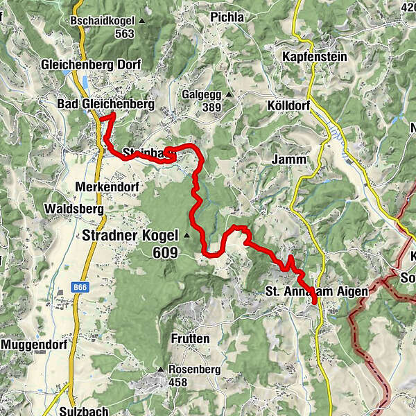
We hike from the Gleichenberger Kogel to the Stradner Kogel and further to St. Anna. On this hike we witness the past - do you see the extinct volcanoes?
- Difficulty
-
difficult
- Rating
-
- Starting point
-
Train station Bad Gleichenberg
- Route
-
Bad Gleichenberg (269 m)0.0 kmBad Gleichenberg0.1 kmSteinbach2.5 kmLounge 813.8 kmVorstatt7.7 kmSchemmingkapelle10.4 kmSchemming10.9 kmRutschen12.9 kmSt. Anna am Aigen13.0 kmPfarrkirche St. Anna13.1 km
- Best season
-
JanFebMarAprMayJunJulAugSepOctNovDec
- Description
-
In the footsteps of the volcanoes is a network of hiking trails through the entire Styrian Volcanic Land. This route shows us stage 2 of the backbone from Bad Gleichenberg to St. Anna am Aigen. We start our hike in the historic spa town of Bad Gleichenberg, which is surrounded by the Gleichenberger Kogeln. We walk through the spa park towards the south, see mighty trees and hear birds chirping. Then we leave Bad Gleichenberg and reach the country road via a sunny path. We cross it, pass a chapel and follow the path towards Stradner Kogel. The Stradner Kogel is the highest elevation (609 m) in southeastern Styria. This high plateau was formed about 2 million years ago and forms a wonderful environment for hiking. Our next stops are the Waltrafelsen and as a viewpoint the Schemmingkapelle. Here we have our destination, St. Anna am Aigen, already in front of us!
- Directions
-
From Bad Gleichenberg train station it is only a few meters to the historic spa park. The spa park of Bad Gleichenberg was laid out in 1837 by Countess Emma von Wickenburg. As we walk south through the park we are accompanied by chirping birds and squirrels. We leave the spa park at the "old fire station" and hike south. Our hike leads us to the main road, which we cross, reach the chapel and the small road to Steinbach.via Steinbach we hike through the mixed forest to the Stradner Kogel, which is with 609m the highest elevation in southeastern Styria. The Stradner Kogel is a basalt plateau and thus has no "real" summit. We cross the plateau and after a short hike we reach the Waltrafelsen. Here we see the "edge" of the basalt plateau. This place is an ancient cult place, which is also evidenced by findings. Our hike continues through the forest, where we reach a wonderful place with a view. The Schemming Chapel is considered an insider tip! Here a wonderful view of St. Anna am Aigen and the entire region opens up!
After a short break we continued our hike through the beautiful vineyards. Steeply downhill into the Pleschbach valley and steeply uphill again. We pass tennis courts and have one last hurdle to most. Soon we reach the village of St. Anna. Here we can once again look at the Schemming Chapel before we let ourselves be seduced by the Styrian wine in the Gesamtsteirische Vinothek.
- Highest point
- 543 m
- Endpoint
-
Vinothek St. Anna am Aigen
- Height profile
-

- Equipment
-
Proper backpack packing makes many things easier: Pack heavy things first. The water bottle should always be within reach in a side pocket. All the things that are often needed, such as sunglasses, camera or hiking map, belong on top. An emergency kit, including blister plasters, belongs in every rucksack and it is always advisable to dress in layers.
- Safety instructions
-
Emergency call mountain rescue: 140
ambulance: 144
European emergency call: 112
firefighters: 122
police: 133Tips when reporting an emergency – Answer these six WH questions: What happened? How many people are injured? Where did the accident happen (are there GPS coordinates)? Who is reporting the incident (callback number)? When did the accident happen? What is the weather like at the site of the incident?
- Tips
-
Be sure to take a break at the Schemming Chapel and end the hike with a glass of wine or fruit juice at the Vinothek.
- Directions
-
By car via the A2 Südautobahn - Ilz exit via Riegersburg and Feldbach to Bad Gleichenberg or via the Gleisdorf-Süd exit to Feldbach and Bad Gleichenberg.
By car via A9 direction Graz, further A2 direction Vienna - exit Gleisdorf-Süd to Feldbach and Bad Gleichenberg
- Public transportation
-
Detailed information about arriving by ÖBB (Austrian Federal Railways) can be found at www.oebb.at or on the Verbundlinie Steiermark website www.busbahnbim.at
With Verbundlinie’s BusBahnBim route planner app, planning your journey has never been easier: simply enter towns and/or addresses, stop names or points of interest to check all bus, train and tram connections in Austria. The app is available free of charge for smartphones – on Google Play and in the App Store
- Parking


- Author
-
The tour Backbone (Rückgrat) / Bad Gleichenberg-St. Anna is used by outdooractive.com provided.


-
Oststeiermark
2125
-
Bad Gleichenberg
371
-
Bad Gleichenberg
154