Kneipp-breath-active-rhythm trail (Kneipp-Atem-Aktiv-Rhythmusweg)


- Brief description
-
Recharge your batteries, find tranquility and bring body, mind and soul into harmony. Find inner harmony in the midst of the natural landscape of the Großharter pond.
- Difficulty
-
medium
- Rating
-
- Starting point
-
In the center of Auffen
- Route
-
Lindenhof Straußenwirt0.0 kmAuffen0.1 kmKapelle Auffen0.1 kmHolzboot1.9 kmNeusiedl1.9 kmLindenhof Straußenwirt4.2 kmAuffen4.7 km
- Best season
-
JanFebMarAprMayJunJulAugSepOctNovDec
- Description
-
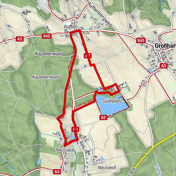
Starting point of the hiking tour is the center of Auffen. The 4.7 km long circular trail activates and puts you in a good mood. Along the hiking trail you will find 12 stations where special breathing exercises can be performed.
- Directions
-
The starting point of the Kniepp-Breath-Active-Rhytmus Trail is in the center of Auffen. Along the trail you will find 12 stations where special breathing exercises can be performed. At the chapel turn left in the direction of Neusiedl. After that you will reach the Großharter natural pond. You can cross the pond by means of a footbridge and then come to the pond tavern. Continue to the mountain bike trail and then along the ostrich enclosure. Now you come back to the starting point in Auffen.
1.start in the center of Auffen
2.at the chapel turn left in the direction of Neusiedl
3.then in the direction of the natural pond Großhart
4.cross the pond with a footbridge to the pond tavern
5.continue to the mountain bike trail
6.along the ostrich enclosure
7.and back to the starting point in the center of Auffen - Highest point
- 437 m
- Endpoint
-
In the center of Auffen
- Height profile
-

- Equipment
-
Proper backpack packing makes many things easier: Pack heavy things first. The water bottle should always be within reach in a side pocket. All the things that are often needed, such as sunglasses, camera or hiking map, belong on top. An emergency kit, including blister plasters, belongs in every rucksack and it is always advisable to dress in layers.
- Safety instructions
-
Emergency call mountain rescue: 140
ambulance: 144
European emergency call: 112
firefighters: 122
police: 133Tips when reporting an emergency – Answer these six WH questions: What happened? How many people are injured? Where did the accident happen (are there GPS coordinates)? Who is reporting the incident (callback number)? When did the accident happen? What is the weather like at the site of the incident?
- Tips
-
GenussCard
- Additional information
-
The Styria Tours App, available for free on Google Play and in the App Store (Android, iOS), offers detailed first-hand information: short facts (length, duration, difficulty, ascent and descent in altitude meters, ratings), map, trail descriptions, altimeter, compass, summit finder, navigation along the tour.
- Directions
-
From direction Vienna:
A2 freeway in the direction of Graz - you take the Sebersdorf/ Bad Waltersdorf exit, then in the direction of Auffen.From direction Graz:
Freeway A2 direction Vienna - you take the exit Sebersdorf/ Bad Waltersdorf, then direction Auffen. - Public transportation
-
Detailed information about arriving by ÖBB (Austrian Federal Railways) can be found at www.oebb.at or on the Verbundlinie Steiermark website www.busbahnbim.at
With Verbundlinie’s BusBahnBim route planner app, planning your journey has never been easier: simply enter towns and/or addresses, stop names or points of interest to check all bus, train and tram connections in Austria. The app is available free of charge for smartphones – on Google Play and in the App Store
- Parking

-

-
AuthorThe tour Kneipp-breath-active-rhythm trail (Kneipp-Atem-Aktiv-Rhythmusweg) is used by outdooractive.com provided.


General info
-
Thermen- & Vulkanland
1324
-
Bad Waltersdorf
624
-
Hartl
182