- Brief description
- Difficulty
-
medium
- Rating
-
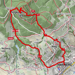
- Starting point
-
Pöllau, Parish church
- Route
-
Ewige Anbetung0.1 kmPfarrkirche Pöllau0.1 kmPöllau0.1 kmKalvarienbergkirche1.2 kmGoldsberghof1.9 kmGoldsberg1.9 kmPöllauberg3.0 kmWallfahrtskirche Maria Pöllauberg3.1 km
- Best season
-
JanFebMarAprMayJunJulAugSepOctNovDec
- Description
-
We would like to invite you to combine your hike in the Pöllauer valley Nature Park and in the ApfelLand-Stubenbergsee with art and cultural enjoyment and savour the culinary delights. The individual organ hiking tours can be easily combined with each other.
Hike from church to church in the Pöllau Valley Nature Park and ApfelLand-Stubenbergsee regions and get to know the advantages of an individual guided tour with the sound of bells and organs. Download the free "Hearonymus" app, select the "Churches in the ApfelLand-Stubenbergsee and Pöllau Valley Nature Park" under "Guides" and your smartphone has become an audio guide.
- Directions
-
This path is also the pilgrimage route from the Pöllau parish church to the Pöllauberg pilgrimage church and part of the Hirschbirn hiking trail towards Pöllauberg, the signposting for which begins at the signposts in the castle park (south of the Parkcafe). We start at the Pöllau parish church and walk along Schmiedgasse to the roundabout at the bypass ("Pöllau Mitte"), where we meet hiking trail 942 north of the Raiffeisenbank as well as the signs "Hirschbirnweg" and "Wallfahrerweg" towards Kalvarienbergkirche (1699). The trail continues over the Goldsberg to St Mary's pilgrimage church on the Pöllauberg.
Alternatives for the way back: Follow hiking trail 946 east of the church from the "Zum Jagawirt" inn, Goger family. The trail leads via Ölkreuz, Obersalberg, Buschenschank Haubenwaller and Hotel Retter red markings (no. 8) or via the Hirschbirnwanderweg trail back to Pöllau. Total duration of the hike via the described alternative return route or Hirschbirnwanderweg trail: approx. 2.5 to 3.5 hours.
- Highest point
- 731 m
- Endpoint
-
Pilgrimage church Pöllauberg
- Height profile
-

- Equipment
-
Small rucksack with water bottle (+ provisions)Sturdy shoes
Appropriate clothing - preferably several layers - "onion principle"
Rain and sun protection
Hiking poles as required
Mobile phone
Small first aid kit
Route description
Before starting the hike, check where you can stop for refreshments, including opening times, or pack suitable provisions. - Safety instructions
-
Important telephone numbers: European emergency call: 112 Emergency call mountain rescue: 140 (if possible, please provide GPS data) Rescue: 144 Fire brigade: 122 Police: 133
The trail is easy to walk and therefore suitable for the whole family.
Correct behaviour when hiking: Rules of behaviour when hiking
A few tips on correct and fair behaviour in the forest: (Source: www.bundesforste.at)
Hikers should avoid visiting the forest approx. 1.5 hours before sunrise and after sunset, as wild animals are particularly active at this time. Plastic bottles, handkerchiefs, cigarette butts etc. have no place in the forest! Please make sure that you do not leave any rubbish in the forest. Camping and making fires is strictly forbidden in the forest! In principle, every person in the forest is allowed to collect 2kg of mushrooms and berries per day for their own use. It is only prohibited if the forest owner expressly forbids it. - Tips
-
Experience the scenic diversity of the Nature Park Pöllau Valley
Plan enough time to savour the culinary delicacies - Additional information
-
Information about the region, places to stop for refreshments and overnight accommodation, excursion destinations etc. can be found here:
Eastern Styria Tourist Board
Nature Park Pöllau Valley office
Castle 1
8225 Pöllau
Current weather
Mobility Eastern Styria with shared taxi SAM
- Directions
- Public transportation
- Parking


- Author
-
The tour Orgelwandern: Etappe Pöllau - Pöllauberg is used by outdooractive.com provided.


General info
-
Oststeiermark
2125
-
Naturpark Pöllauer Tal
1089
-
Pöllau
344