- Brief description
-
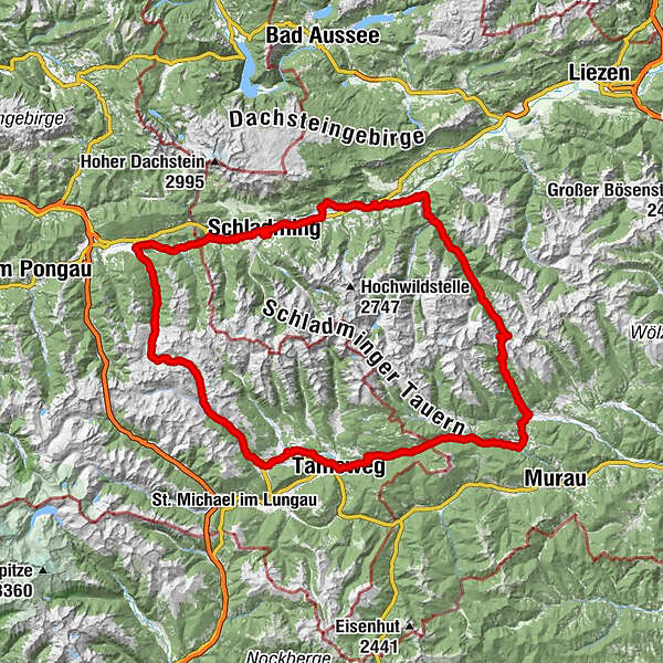
This very long, condition- and strength- demanding tour circles the Schladminger Tauern with a wonderful mountain panorama.
- Difficulty
-
difficult
- Rating
-
- Starting point
-
Planet Planai Schladming
- Route
-
Annakapelle0.5 kmStadtpfarrkirche St. Achaz0.5 kmSchladming (745 m)0.8 kmFreizeitstüberl8.1 kmPichl bei Schladming8.4 kmPichl8.4 kmGleiming9.8 kmHotel Brunner9.9 kmForstauer Wirt13.7 kmForstau13.9 kmUnterreith14.1 kmTauernblick22.4 kmHöggen22.7 kmGasthof Waldherr25.7 kmSchrotter Kapelle26.4 kmUntertauern29.3 kmGnadenfall33.2 kmJohanneswasserfall35.9 kmZum Heiligen Petrus in Banden38.8 kmSonnhof Servicebahn Talstation39.8 kmObertauern40.2 kmRadstädter Tauern (1,738 m)40.3 kmTweng48.0 kmPfarrkirche Heiliges Kreuz48.1 kmLagler50.3 kmPurn50.3 kmVorderwinkel50.6 kmDengen50.8 kmMauterndorf57.3 kmSteindorf59.4 kmDrei Kreuze59.5 kmMoar Kapelle59.5 kmDiktlerkapelle59.5 kmKristan-Kreuz59.5 kmBlasikreuz59.6 kmBruckdorf61.8 kmAlthofen62.4 kmMariapfarr63.4 kmUnsere Liebe Frau Maria Himmelfahrt63.4 kmFriedhofskapelle63.5 kmMiesdorf64.2 kmKreuzbühelkapelle64.5 kmErnesto64.6 kmKarlwirt65.2 kmTullnberg68.2 kmTamsweg69.4 kmProding70.5 kmPöllitz71.2 kmSauerfeld73.4 kmTraning75.0 kmAtzmannsdorf76.5 kmPenk77.8 kmSchloßberg78.3 kmSchwarzenbichlkapelle80.0 kmSchwarzenbichl (1,241 m)80.0 kmSchwarzenbichl80.4 kmIn der Stadt81.5 kmJohanneskreuz82.0 kmPfarrkirche Seetal82.0 kmSeetal82.1 kmGasthaus Klauswirt82.6 kmSeebach89.2 kmRatschfeld91.4 kmRanten92.6 kmTratten93.9 kmRottenmann95.1 kmRottenmanner-Kapelle95.4 kmSchöder98.5 kmBaierdorf99.9 kmDorferhütte107.4 kmAussichtspunkt Katschtalkehre (1,550 m)110.3 kmSankt Nikolai im Sölktal121.1 kmMößna124.2 kmGasthof Sölkstub'n125.2 kmÖdwirt128.5 kmAlmstüberl129.3 kmFleiß129.5 kmGroßsölk133.2 kmGatschberg136.4 kmStein an der Enns138.1 kmRestaurant Hubertus138.4 kmImbiss Zum Krotzstoa139.0 kmLandgasthof Bierfriedl144.0 kmPruggern144.2 kmHotel Pruggererhof144.3 kmAssach147.4 kmPfarrkirche St. Nikolaus147.5 kmAich148.8 kmWeißenbach152.3 kmHaus im Ennstal155.0 kmKulmiNarium156.6 kmOberhaus157.1 kmLehen158.0 kmMauterndorf159.4 kmSchladming (745 m)160.9 kmSeebacher-Siedlung161.3 kmStadtpfarrkirche St. Achaz162.3 kmAnnakapelle162.3 km
- Best season
-
JanFebMarAprMayJunJulAugSepOctNovDec
- Description
-
A very long tour that continues counterclockwise around the Schladminger Tauern from the Schladming starting point via Radstadt, Untertauern and Obertauern. Sometimes steep and long climbs are to be mastered, therefore this tour is very strenuous and requires good physical condition.
- Directions
-
Starting point of the tour is Schladming, near the Planai valley station. From there turn left into Coburgstraße until you reach the roundabout. Take the third exit and drive along Schulgasse. Turn right at the end of the street and follow Dachsteingasse to the intersection with Roseggerstraße. Turn left, cross the Enns and take the first exit at the roundabout.
Follow Ramsauer Straße for about 600 m and then turn left into Hochstraße. Drive about 4 km along the Hochstraße, then turn into the Ennstal Bundesstraße at Stegerweg and drive along the street for a short time (200m). Then turn left into the Ennsweg and follow the road along the Enns for 2 km. Circle the Pichl lake resort and follow the path that runs between the main road and the railway tracks for about 1.5 km after Gleiming.
In Gleiming turn left and drive along the Gleiming main road for about 4 km to Forstau. Follow the road from Forstau and after about 7 km you will reach Radstadt. At the roundabout take the third exit towards Obertauern. After 20 constantly rising kilometres, at which Untertauern is also crossed, Obertauern is reached, a first highlight of the tour.
From there it continues downhill along the B99 for 17 kilometres to Mauterndorf. Via Hammerstraße, which branches off to the right about one kilometre before Mauterndorf, you cross the village of Mauterndorf. The path crosses the Katschberg main road and continues along the Turracher main road past the airfield. At Steindorf follow the road to the main road. After about one kilometre, however, it is abandoned again. Turn left and follow the road towards Mariapfarr. At the junction with the Weisspriacher Landesstraße turn left and at the end of the road turn left again onto the Lungauer Landesstraße. Follow the road, cross Mariapfarr and follow the road for about two kilometres to Lintsching. Change there to the Untschinger Landesstraße and after about one kilometre turn into the forest,
After about one kilometre you leave the forest in the direction of Litzelsdorf. At the end of Litzelsdorf turn left onto the Murtal Bundesstraße/Zinsgasse. Follow the road to Tamsweg. Turn left before the Leißnitzbach bridge and follow Griesgasse. After about one kilometre the road joins the Murtal Bundesstraße again. After three kilometres, leave the main road briefly on the left and drive via Burgstall and Traning through Sauerfeld.
After a short passage through the woods, you change again to the main road at Atzmannsdorf. The tour follows the main road for 20 kilometres before turning left at Tratten in the direction of Schöder. After 3.3 kilometres, during which Rottenmann is also crossed, Schöder is reached.
For a long time it went on the plain, now follows the hardest ascent of the tour. 14 kilometres uphill, before the pass summit of the Sölkpass is reached. 26 kilometres further down the Sölkpass road to Stein an der Enns, then the Sölkpass is overcome. Along the Steiner Landesstraße in the direction of Tunzendorf, the trail slowly leads back to the starting point.
The path leads through the villages of Tunzendorf, Moosheim and Pruggern to an accompanying path along the Ennstal main road. Follow the accompanying path, which runs along the main road for about 2 km to Assach. Turn right in Assach and then immediately left into Assachweg. Cross the town of Assach and continue along Assacherstraße in the direction of Aich. Turn right in the centre of Aich and follow the road slightly uphill towards Sonnberg and Weißenbach. Turn left at Sonnberg and follow the road slightly downhill to Weißenbach. In Weißenbach pass the chapel, then take the road towards Haus im Ennstal. Follow the road to the Hauser Kaibling valley station, then turn right and cross the village of Haus im Ennstal. Follow the road from Haus via Lehen and Ennsling for 7 kilometres to the Schladming district of Untere Klaus. Follow the road until you pass under the main road, then continue along Katzenburgweg to Roseggerstraße. There again like at the beginning of the tour over the same route back to the Coburgstraße.
- Highest point
- 1,793 m
- Endpoint
-
Planet Planai Schladming
- Height profile
-

- Equipment
-
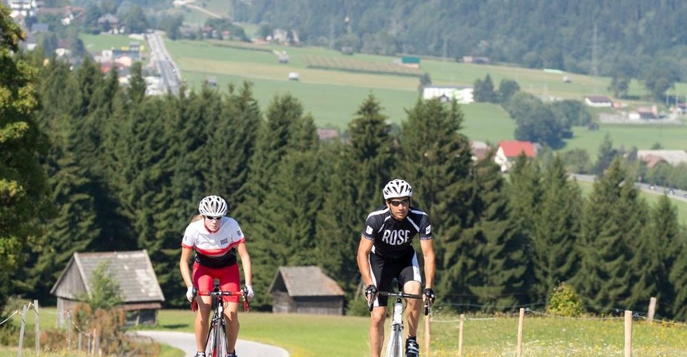
Biking clothes
Bike helmet
Enough to drink
Rain gear - Safety instructions
-
ATTENTION: Due to storm damage, the Sölkpass road will probably be closed until 2018. The tour can only be driven to Schöder at the Sölkpass.
Even on our bike paths you are not protected from general dangers, such as weather upsets or sudden obstacles. Prepare yourself accordingly for your tour, ride carefully and show consideration for other road users.
- Tips
-
Take care to drink enough on this long track.
- Additional information

-

-
AuthorThe tour Around the Schladminger Tauern is used by outdooractive.com provided.