- Brief description
-
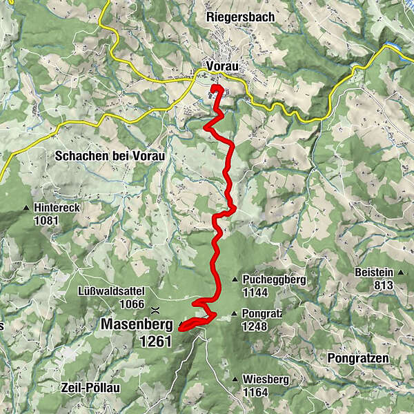
On the MTB trail "The Grand Jogl" you can also complete a short tour up the Masenberg. The starting point is the URKRAFT Arena in Vorau in the Joglland - Waldheimat region.
- Difficulty
-
medium
- Rating
-
- Starting point
-
URKRAFT Arena Vorau
- Route
-
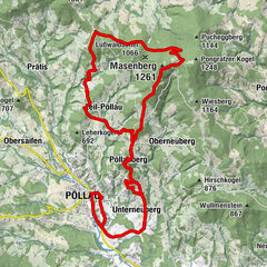
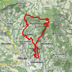
Vorau0.1 kmGlückskapelle8.9 kmSchutzhaus Masenberg9.0 kmMasenberg (1,261 m)9.0 kmVorau18.2 km
- Best season
-
JanFebMarAprMayJunJulAugSepOctNovDec
- Description
-
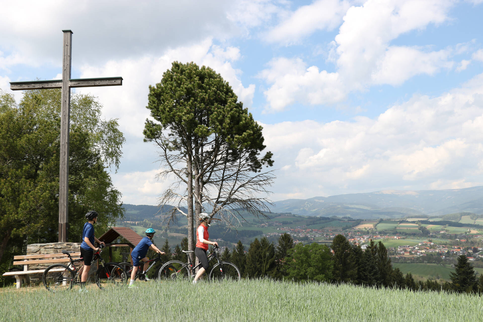
Starting from the URKRAFT Arena, the route leads to the local mountain of Vorau, the 1261-metre-high Masenberg. Along the route there are also great viewing opportunities, such as the Erzherzog Johann Höhe, and places to stop for refreshments. The panorama at the summit is also well worth seeing.
On this tour you follow the signs of the cycle route "The Grand Jogl", which covers the entire Joglland - Waldheimat region over 187 kilometres. Here you are on a section of it. This is a stretch tour, so the way back from the Masenberg to the starting point is via the same route as the ascent.
- Directions
-
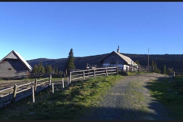
We start the tour at the URKRAFT Arena - the leisure & sports centre in Vorau. There is a large car park, public toilets, a café and you can test your balance in the movement park. From the Urkraft Arena we drive along Lindenallee towards the monastery and turn right before the monastery gate down towards Schafleiten and Brühl. We drive over the Brühl and turn right and drive up Amtmannweg to the Erzherzog Johann Höhe. The Erzherzog Johann Höhe is a viewing platform with binoculars where we enjoy a wonderful all-round view of the region. We take the turnoff to the Erzherzog Johann Höhe and turn left off the main trail. The main path leads us past the Gasthof Erzherzog Johann Höhe - Kagerwirt to the main road, which we follow uphill. The next turn is to the right and we are directly in front of the forest road that leads us up to the Masenberg. Once we reach the top, a fantastic view awaits us, as well as the Olmstoll and the Kernstockhütte for food and drink.
- Highest point
- 1,249 m
- Endpoint
-
URKRAFT Arena Vorau
- Height profile
-

- Equipment
-
Helmet
Sunglasses
Water bottle
provisions for on the way
Protective clothing if necessary (knee pads etc.)
Sporty clothing
Sturdy shoes
Gloves
Rain jacket/windbreaker
Repair kit (air pump, repair kit, spare inner tube, multitool, etc.)
Light
First aid kit
Maps - Safety instructions
-
Important telephone numbers: European emergency call: 112 Emergency call mountain rescue: 140 (if possible, please provide GPS data) Rescue: 144 Fire department: 122 Police: 133
Fair play rules for mountain biking:
Pedestrians have priority
show consideration for pedestrians and hikersRespect for nature
Avoid noise and rubbishRide only on paths
Never ride off marked roads and paths
Drive on sight
Control your speed and be ready to brake
Never ride without a helmet, even uphill
Observe rules: Observe road traffic regulations and driving bans Grazing cattle
approach at walking pace and close grazing gates.
Only use technically sound mountain bikes check regularly
Take an emergency kit with you
Take a repair kit and bandages with you
Correct self-assessment: condition and riding technique
The use of the trail is at your own risk!
Please keep to the opening hours: From 01 April to 01 November: from 1 hour after sunrise to 1 hour before sunset.
- Tips
-
Also take time at the URKRAFT Arena to try out the Pump Track or the Movement Park!
- Additional information
- Directions
-
About Vienna: Take the A2 – Südautobahn to the Friedberg/Pinggau exit. Then via Dechantskirchen and Bruck/Lafnitz to Vorau or: Via the A2 - Südautobahn and the S6 Semmering expressway to Krieglach. From there via the Alpl to the Joglland - Waldheimat region. From Graz: Via the B72 to Weiz and further to Birkfeld in the Joglland - Waldheimat region Route planner for your journey
- Public transportation
- Parking
-
Parking spaces are available at the stated starting point, the URKRAFT Arena.
- Author
-
The tour Vorau – Masenberg Mountainbike Tour is used by outdooractive.com provided.


General info
-
Thermen- & Vulkanland
114
-
Naturpark Pöllauer Tal
130
-
Vorau
65