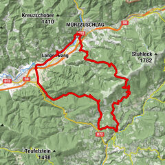
Hochwechselrunde

Logo Hochwechselrunde
Tour data
38.82km
727 - 1,732m
Distance
1,404hm
Ascent
04:00h
 
Duration
Brief description

Ausgewogene Tour mit diversen Möglichkeiten zur Variantion bei der Abfahrt

Rating
Technique
Fitness
Landscape
Experience
Starting point

Dorfplatz St. Lorenzen am Wechsel

Route
Sankt Lorenzen am Wechsel
Hl. Laurentius
0.0 km
Schmaleck
7.7 km
Windhag (1,395 m)
8.4 km
Hochwechsel (1,743 m)
22.7 km
Wetterkoglerhaus
22.8 km
Vorauer Schwaig
26.9 km

Highest point
1,732 m

Rest/Retreat

Hochwechsel, Vorauer Schwaig


5,0
Overall rating

5

100

%

4

0

%

3

0

%

2

0

%

1

0

%

GPS Downloads
  • GPX GPS Exchange Format (XML)
  • KML Google Earth, Google Maps
QR Download Codes for Mobile Phones

Surfaces

Asphalt
Gravel
Mountain paths
Single trails
Trial
Traffic
Other tours in the regions

Popular tours in the area

Mürzzuschlag: Almentour

medium Mountainbike
52.11km | 1806hm | 03:30h

MTB round tour: Pöllau - Pöllauberg - Masenberg and back

difficult Mountainbike
33.1km | 1143hm | 04:00h

Grand Wexl Tour

difficult Mountainbike
51.73km | 1383hm | 05:00h

Mürzzuschlag: Zur Ganzalm

medium Mountainbike
15.7km | 692hm | 02:00h