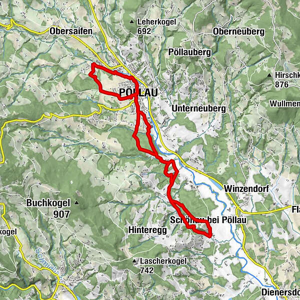
Laufen/NW: Schlosspark - Hinterbrühl - Schönaudorf - Schlosspark


- Brief description
-
For runners and Nordic walkers, there are two signposted "running routes" in the market town of Pöllau...
- Difficulty
-
medium
- Rating
-
- Starting point
-
Pöllau, castle park
- Route
-
PöllauFeldhöf2.0 kmSpielplatz Hinterbrühl2.5 kmPöllau4.5 kmFreiberg7.7 kmNaturjuwel Schönauklamm11.0 kmSchönaudorf11.6 kmBurgstall11.9 kmBuschenschank Krobath11.9 kmSchönau bei Pöllau12.0 kmHimmelskönigin14.9 kmFreiberg15.1 kmPöllau18.2 km
- Best season
-
JanFebMarAprMayJunJulAugSepOctNovDec
- Description
-
... If you combine the routes, the total length is 18.5 km.
The shorter route leads to the picturesque Hinterbrühl and is 4.8 km long,
while the longer section takes us to Schönaudorf and is 13.7 km long.However, if you want even more scenic variety and elevation gain,
you can use the 190 km of well-marked circular hiking trails, taking your personal fitness level into account. To do this, simply set the filter for "Hiking" in outdooractive or use the hiking map, which is available from the tourist office for € 2.50.
- Directions
-
Starting from the Schlosspark, the shorter route takes us to the picturesque Hinterbrühl and is 4.8 km long. We return to the center of Pöllau, pass the castle park and continue south - this longer section takes us to Schönaudorf and is 13.7 km long.
These routes lead through varied terrain and only include slight inclines. The total time of 3 hours is a guideline for "hikers.
- Highest point
- 482 m
- Endpoint
-
Pöllau, castle park
- Height profile
-

- Equipment
-
small rucksack with water bottle (+ provisions)
Sturdy shoes
Appropriate clothing - preferably several layers - "onion principle"
Rain and sun protection
Hiking poles as required
Mobile phone
Small first aid kit
Route description
Before starting the hike, check where you can stop for refreshments, including opening times, or pack suitable provisions. - Safety instructions
-
Important telephone numbers:
European emergency call: 112
Emergency call mountain rescue: 140 (if possible, please provide GPS data)
Rescue: 144
Fire brigade: 122
Police: 133
The trail is easy to walk and therefore suitable for the whole family.
Correct behavior when hiking/running: Rules of behaviour when hiking
A few tips on correct and fair behaviour in the forest:
Hikers/Runners should avoid visiting the forest approx. 1.5 hours before sunrise and after sunset, as wild animals are particularly active at this time. Plastic bottles, handkerchiefs, cigarette butts etc. have no place in the forest! Please make sure that you do not leave any rubbish in the forest. Camping and making fires is strictly forbidden in the forest! In principle, every person in the forest is allowed to collect 2kg of mushrooms and berries per day for their own use. It is only prohibited if the forest owner expressly forbids it. - Tips
-
Experience the scenic diversity of the Pöllau Valley Nature Park
Also plan enough time to enjoy the culinary delicacies
- Additional information
-
Information about the region, places to stop for refreshments and overnight accommodation, excursion destinations etc. can be found here:
Tourism region Eastern Styria
Nature Park Pöllauer Valley office
Schloss 1, 8225 Pöllau, Austria
- Directions
- Public transportation
- Parking
- Author
-
The tour Laufen/NW: Schlosspark - Hinterbrühl - Schönaudorf - Schlosspark is used by outdooractive.com provided.


General info
-
Oststeiermark
111
-
Naturpark Pöllauer Tal
28
-
Pöllau
3