"alpannonia" - feeder: Ratten - Roseggerhaus on the Pretul


- Brief description
-
From the UNESCO World Heritage site of Semmering or the high-altitude health resort of Fischbach to the edge of the Pannonian plain near Köszeg, a trail full of variety and attractions of nature leads: alpannonia®.
Or you can start the trekking tour in the former mining village of Ratten in Peter Rosegger's Waldheimat, hike from there to the Roseggerhaus on the Pretul and then start the alpannonia main trail.
- Difficulty
-
medium
- Rating
-
- Starting point
-
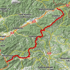
Local center Ratten
- Route
-
RattenKirchenwirt0.4 kmGrubbauer5.3 kmRoseggerhaus11.5 km
- Best season
-
JanFebMarAprMayJunJulAugSepOctNovDec
- Description
-
The former mining village of Ratten in Peter Rosegger's Waldheimat is the starting point for this stage. Even today, the mining museum recalls the work of the miners underground more than 60 years ago. Also in the park of the village sculptures and replicas remind of the mining of that time. Once you have reached the Roseggerhaus on the Pretul after the ascent, there are also some interesting things to see there. In addition to the magnificent view of the surrounding mountains, the striking Peter Bergner Warte also stands out. This was built in memory of the innkeeper of the Rosegger Schutzhaus, Peter Bergner, who was murdered in 1904.
- Directions
-
We start in the center of Ratten
Here we hike along the Niesnitzgraben, before we turn into the hiking trail 742
We hike along the trail until we come to the Eichtinger farm
We continue on trail no. 742 until we finally come to the Pretulalpe - Highest point
- 1,578 m
- Endpoint
-
Rosegger House on the Pretul
- Height profile
-

- Equipment
-
Small backpack with water bottle (+ provisions)
Sturdy shoes
Appropriate clothing - if possible several layers - "onion principle".
Rain and sun protectionWalking sticks as required
Mobile phone
Small first aid kit
Route description
Before starting the hike, check the possibilities for refreshments, including opening times, or pack appropriate food and drink
- Safety instructions
-
European emergency call: 112
Emergency call mountain rescue: 140 (if possible please provide GPS data)
Rescue: 144
Fire brigade: 122
Police: 133
A few tips on correct and fair behaviour in the forest: (Source: www.bundesforste.at )
Hikers should avoid visits to the forest about 1.5 hours before sunrise and after sunset, as wild animals are particularly active during this time.
Plastic bottles, handkerchiefs, cigarette butts etc. have no place in the forest! Please make sure that you do not leave any rubbish in the forest.
Camping and lighting fires are strictly forbidden in the forest!
In principle, every person is allowed to pick 2 kg of mushrooms and berries per day for personal use. It is only prohibited if the forest owner expressly forbids it.
- Tips
-
Hike the entire alpannonia long distance trail in 6 day stages from Fischbach to Köszeg!
- Additional information
-
Tourism Association East Styria
Office Joglland - Waldheimat
8255 St. Jakob im Walde
church quarter 24
Tel.: +43 3336 20255
Joglland-Waldheimat
Oststeiermark
Aktuelles Wetter
Mobilität Oststeiermark mit Sammeltaxi SAM
RegioBus
- Directions
- Public transportation
- Parking
-
Parking spaces in the municipality of Ratten.


- Author
-
The tour "alpannonia" - feeder: Ratten - Roseggerhaus on the Pretul is used by outdooractive.com provided.


General info
-
Hochsteiermark
4066
-
Joglland - Waldheimat
1506
-
Ratten
332