- Brief description
-
An easy winter walk to Rohrmoosgut and Riedlgut in a quiet, remote location in Dienten am Hochkönig.
- Difficulty
-
easy
- Rating
-
- Starting point
-
Village Dienten
- Route
-
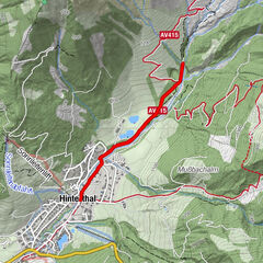
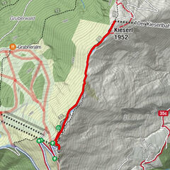
Dienten am HochkönigBürglalm0.2 kmHöfl-Zachhof0.7 km
- Best season
-
AugSepOctNovDecJanFebMarAprMayJunJul
- Description
-
We park our car for free in the Dienten ski centre in the multi-storey car park - from there we cross the parking deck until we reach a barrier. Here the tunnel to the local road "Reizegg" begins, which also leads to Bründlstadl. We follow the road straight on until we reach the Hochkönig Bundesstraße. Here we turn left and follow the road downhill for about 400 m until we reach the district of Fuchsau. In this area we walk on the road - so please ATTENTION CAR - there is no pavement! Arrived at the roundabout we follow the Hochkönig Bundesstraße in direction Filzensattel or Maria Alm/Saalfelden. After approx. 1.5 km the Rohrmoos freight road branches off to the right. We follow the road until we reach the farms Rohrmoos and Riedlgut. Here we have a wonderful view of the mountains and the valley.
The way back is the same way (Bundesstraße/Reizegg/Skizentrum Dienten) - Directions
-
We park our car for free in the Dienten ski centre in the multi-storey car park - from there we cross the parking deck until we reach a barrier. Here the tunnel to the local road "Reizegg" begins, which also leads to Bründlstadl. We follow the road straight on until we reach the Hochkönig Bundesstraße. Here we turn left and follow the road downhill for about 400 m until we reach the district of Fuchsau. In this area we walk on the road - so please ATTENTION CAR - there is no pavement! Arrived at the roundabout we follow the Hochkönig Bundesstraße in direction Filzensattel or Maria Alm/Saalfelden. After approx. 1.5 km the Rohrmoos freight road branches off to the right. We follow the road until we reach the farms Rohrmoos and Riedlgut. Here we have a wonderful view of the mountains and the valley.
The way back is the same way (Bundesstraße/Reizegg/Skizentrum Dienten)
- Highest point
- 1,263 m
- Endpoint
-
Riedlgut
- Height profile
-

- Equipment
-
Sturdy, waterproof footwear
Possibly snow shoes
Appropriate winter clothing with gloves
Adjustable poles
Bagpack with hot drink and light snack
Necessary medication
First aid kit - Safety instructions
-
Stay on the marked hiking trails. Small steps and a steady pace save energy going uphill and protect your joints going downhill. If you tilt your upper body slightly forward when going downhill, you reduce the risk of slipping. Check the weather forecast. Fog and bad weather can come surprisingly quickly. Turn back in good time before you take a risk. Do not leave waste in the countryside
Emergency numbers: Alpine emergency call: 140
International emergency call: 122 - Tips
-
A camera should not be missing!
- Additional information
- Directions
-
Coming from Salzburg: Take the A10 freeway to the Bischofshofen exit, then take the B311 in the direction of Bischofshofen. Follow the Hochkönig Bundesstraße/B164 to Mühlbach and further to Dienten.
Coming from Innsbruck/ Kufstein: On the Loferer Straße/B178 in the direction of St. Johann i.T., then on the Hochkönig Bundesstraße/B164 via Saalfelden and Maria Alm to Dienten or to the Filzensattel.
A valid vignette is required to use the Austrian motorway and motorway network. It is also compulsory to carry a first-aid kit, warning triangle and high-visibility waistcoat. Further information can be found under Asfinag. - Public transportation
- Parking
-
Free parking at the Dienten Ski Centre
- Author
-
The tour Winter hiking to Rohrmoosgut is used by outdooractive.com provided.


General info
-
Hochkönig
157
-
Dienten am Hochkönig
50