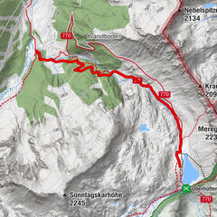
Lignitzsee (toproute)

Logo Lignitzsee (toproute)
Tour data
15.55km
1,374 - 1,974m
Distance
603hm
602hm
Ascent
04:24h
 
Duration
Brief description

Wandeling vanuit het dal naar de Lignitzsee en terug over hetzelfde pad.

Difficulty
easy
Rating
Technique
Fitness
Landscape
Experience
Route
Hintere Lignitzhütten
4.0 km
Hintere Lignitzhütten
11.6 km
Best season
Jan
Feb
Mar
Apr
May
Jun
Jul
Aug
Sep
Oct
Nov
Dec
Highest point
1,974 m

Overall rating

5

0

%

4

0

%

3

0

%

2

0

%

1

0

%

Error
An error has occurred. Please try again.
Thank you for your review

Rating has been deleted

GPS Downloads
  • GPX GPS Exchange Format (XML)
  • KML Google Earth, Google Maps
QR Download Codes for Mobile Phones
Other tours in the regions

Popular tours in the area

Riesach Wasserfälle

Hiking
4.73km | 292hm | 03:00h

From the Vögeialm to the Oberhüttensee

easy Hiking
3.13km | 465hm | 01:30h

Höchstein (2.543 m)

difficult Hiking
11.25km | 805hm | 06:00h