Tour data
16.86km
883 - 2,093m
Distance
1,324hm
1,323hm
Ascent
05:00h
 
Duration
Brief description

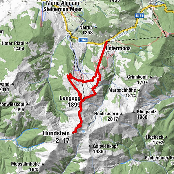
Tour durchs freie Gelände auf den höchsten Grasberg Österreichs. Panoramaaussicht

Route
Schwarzeckalm
0.0 km
Langegg (1,899 m)
4.4 km
Statzerhaus
7.5 km
Hundstein (2,117 m)
7.5 km
Steinerne Manndln
10.9 km
Abergalm
13.7 km

Highest point
2,093 m
Height profile

Author
The tour Hundstein 2117m is used by outdooractive.com provided.

Overall rating

5

0

%

4

0

%

3

0

%

2

0

%

1

0

%

Error
An error has occurred. Please try again.
Thank you for your review

Rating has been deleted

GPS Downloads
  • GPX GPS Exchange Format (XML)
  • KML Google Earth, Google Maps
QR Download Codes for Mobile Phones
Other tours in the regions

Popular tours in the area

Summit tour Taghaube

difficult Hiking
6.25km | 768hm | 03:00h

Wanderung zur Ostpreußenhütte in Werfen (1.630 m)

medium Hiking
11.23km | 726hm | 04:30h

Kitzsteinhorn 3.203 m - Ascent to the peak

difficult Hiking
0.3km | 150hm | 00:45h

Schwalbenwand Nr. 80, 81, 82

medium Hiking
12.99km | 818hm | 05:00h