

© Saalfelden Leogang Touristik GmbH - Saalfelden Leogang

- Brief description
-
2nd Day - Variation B
- Difficulty
-
medium
- Rating
-
- Starting point
-
Maishofen
- Route
-
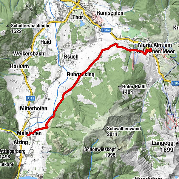
Maishofen0.1 kmSchloss Kammer1.3 kmOberhaus3.3 kmHl. Gotthard4.1 kmGerling4.2 kmGerlingerwirt4.3 kmRuhgassing5.2 kmDeuting6.0 kmHof6.7 kmAlmdorf8.2 kmFriedenskapelle10.4 kmSchloßberg10.6 kmMaria Alm am Steinernen Meer10.7 km
- Best season
-
JanFebMarAprMayJunJulAugSepOctNovDec
- Description
-
Maishofen
Schloss Kammer (rest point)
Gerling
Hof
Almdorf
Maria Alm
- Directions
-
The safe alternative is the valley route, along the right side of the valley past Schloss Kammer, Oberhaus and the small Saalfelden communities of Gerling - Ruhgassing - Deuting - Hof to Almdorf and from here via the narrow road toward Gasthof Hinterreit, going up a slight ascent, then straight ahead past the Brieflerlehen to the Friedenskapelle (Peace Chapel) and then a short way into the valley and the town of Maria Alm.
- Highest point
- 875 m
- Endpoint
-
Maria Alm
- Height profile
-

- Equipment
-
climbing boots, map of trails, first-aid equipment,
cagoule, sun cream, beverage / food, binoculars
- Safety instructions
-
European Emergency Number: 112
Austrian Mountain Rescue Service: 140
Please note the opening hours of the alpine huts!
- Additional information

-

-
AuthorThe tour Saalachtal Tour - 2nd Day - Variation B is used by outdooractive.com provided.
GPS Downloads


Other tours in the regions
-
Saalfelden - Leogang
1814
-
Saalfelden
466


